Before the Fire

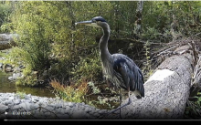
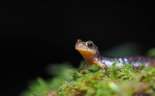
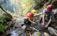
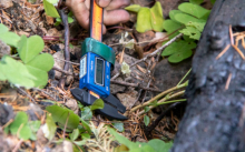
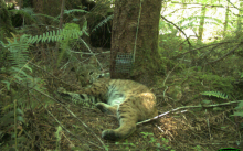
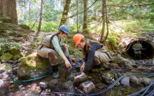
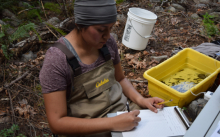
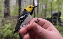
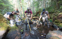
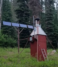
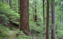
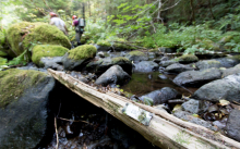
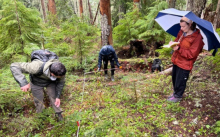
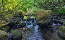
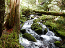
The seeps and cold, fast-flowing headwater streams in the Andrews Forest are home to one of the Pacific Northwest's most charismatic, and yet little understood, species: the Cascade torrent salamander (Rhyacotriton cascadae). The entire family is endemic to the PNW, and two of the four species are currently being considered for listing under the Federal Endangered Species Act. These salamanders are biphasic, with a larval form that can take up to 5 years to metamorphose into a terrestrial form that is still highly sensitive to desiccation and changes in temperature. Despite this, the salamanders can be found in intermittent streams, as they are thought to utilize the hyporheic zone, where groundwater and subsurface stream water mix. The impacts of climate change will likely result in a significant reduction in available habitat to the salamanders, and their ability to disperse to suitable aquatic environments will be crucial to their long-term survival. A landscape genomics study at the Andrews Forest is focused on answering several questions: Is movement tied completely to streams, or do adults cross forest and ridges to move between streams? What does dispersal look like within, between, and among stream networks? What landscape features facilitate or impede movement? 

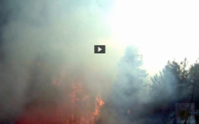
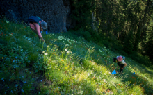
Graduate student Christopher Cousins is leading the study. He shares: “Our project was cut short due to the Lookout Fire, but we are hoping that our existing samples and data will be able to address our questions.  As part of our sampling, we visited sites affected by the 2020 Holiday Farm Fire. Although the burned sites looked rough, we were able to find multiple torrent salamanders at streams impacted by the fire, by searching deep in the stream substrate. We found salamanders of multiple age classes, indicating that not only did salamanders survive the fire, but that reproduction had occurred since. It's likely that torrent salamanders can weather fire events by moving vertically in the stream, using the same strategy they use to live in intermittent streams. Although my heart aches for the Andrews and the forest as it burns, knowing that Cascade torrent salamanders will ride out the fires in subsurface refugia provides a sense of relief.” 

Check out Christopher Cousins’ Instagram to see his stunning, up-close images of salamanders and other wildlife. 

First posted September 22, 2023

Forests and streams are inextricably linked in our western Oregon landscapes, so the significant changes to the forest resulting from the fire will inevitably affect the streams.  As research from Mack Creek in the Andrews Forest has demonstrated, wood input from the forest fundamentally shapes the geomorphology and habitat of streams. In McRae Creek, OSU professor Dana Warren and his team have been exploring how the riparian forest canopy impacts light on streams which, in turn, affects ecological processes in those streams. They initially looked at how historic timber management affected light availability in streams and the impact of that light availability on nutrient limitation and aquatic primary production.  They also created an experimental canopy gap over the stream in one of the tributaries to McRae Creek and quantified how fish, invertebrates, temperature, primary production and nutrients changed with the creation of a light patch.  The impacts of the Lookout Fire will far exceed the impacts of the experimental small gap and will re-open canopies in areas of past clear-cuts that had regenerated to dense stands of alder and fir.  In the coming years we will learn about the resilience of streams to the loss of riparian forests and how ecosystem processes and aquatic biota respond to loss of forest canopy cover and changes in stream hydrology following fire. See our online album: images of the gap study in 2017.

First posted September 20, 2023

How do you take the pulse of a tree?  High-precision dendrometer bands like the ones pictured here can measure daily fluctuations in water balance of a tree bole, in addition to its seasonal growth.  The summer drought experienced by trees at the Andrews Forest is one of many stressors that has been increasing over time with climate change.  While the tree species that have thrived in this landscape for millennia are adapted to wet winters and dry summers, prolonged drought combined with heat waves can stress even the drought-tolerant Douglas fir trees and lead to early shut down of stem growth.  An extreme example of this was the 2021 June heat wave that caused many trees subjected to record high temperatures to cease diameter growth abruptly and drop heat-damaged foliage. In the dry season we see tree stems contract during the late morning and afternoon as water is moved from the stem to foliage to meet the tree’s transpiration needs and then expand overnight as soil water replenishes stem water, at least partially (near real-time graphs of some of the dendrometers are posted here).  Over the course of a strong dry season like we are experiencing in 2023 even the nighttime maximum circumference decreases from day to day, as growth ceases and stem water cannot be fully recharged. One downside to this type of dendrometer: cables everywhere.  And cables and fire do not mix well.  So far nine of our dendrometer plots have been visited by the Lookout Fire; we don’t expect the dendrometers and cables have made it, but we hold out hope for the trees.   

First posted September 19, 2023

The Lookout Fire and initial forest responses may be the current prime example of climate change impacts in the Andrews Forest, as anticipated more than 30 years ago. In a 1992 paper, Andrews Forest researchers predicted that, “the most rapid and extensive biotic changes in forests from climate change will be caused by altered disturbance regimes. Disturbances create the conditions for change in ecosystems, effectively doing the work of eliminating the established forest with its inertia, or tolerance of altered climate conditions. … Increased frequency of fire is certain under the climate change scenario, and greater intensities are probable” This paper goes on to say, “the most environmentally sensitive stage for western tree species is at the time of seedling establishment.”  The predictions of the 1992 paper seem to be playing out here and now: climate warming may be enhancing wildfire regionally, and it also may influence forest succession after wildfire.  Ongoing work by Andrews Forest researchers on vegetation response to fire is poised to interpret forest response to simultaneous increased fire and warming.

First posted September 18, 2023

What wildlife lives in the HJ Andrews Experimental Forest, and what do those animals do in a wildfire? Marie Tosa, a PhD graduate student at Oregon State University, conducted a camera trap study and scat study of mammalian carnivores in and around the Andrews Forest from 2017-2019. Marie’s surveys detected a diverse array of carnivores including cougars, black bears, coyotes, raccoons, opossums, gray foxes, mink, short-tailed and long-tailed weasels, striped skunks, and Marie’s favorite, western spotted skunks. Many of these carnivores in the Oregon Cascades have large home ranges and are territorial, so they exist at low densities. The direct impacts of wildfire on mammalian carnivores are not well understood, but wildlife in this area are likely resilient and adapted to wildfires that burn at low and mixed severities. Large carnivores can typically escape fires by moving out of the fire footprint and smaller carnivores can find fire refugia, escape to underground burrows, or climb high into the canopy.

First posted September 14, 2023

OSU Professors Dana WarrenCatalina Segura, and PhD student Madelyn Maffia are investigating the response of trout and salamanders to drought conditions in a tributary of McRae Creek. The researchers are using an experimental approach to mimic drought by (1) diverting stream flow to create a low-flow reach and (2) passively heating water through a coil system to increase water temperature. The experiment was disrupted by the Lookout Fire that is burning across McRae Creek and its tributaries. The loss is upsetting because of the time and effort that went into setting up the experiment, and because the findings would have had imminent relevance of understanding of how trout and salamanders respond to the drought during the hot and dry conditions often seen with wildfires. 

Photos and more about the study are on our online photo albums for the 2021,  2022, and 2023 drought experiment field seasons.

First posted September 13, 2023

The Lookout Fire, as with the 2020 Holiday Farm Fire before it, triggers a rush of emotions and a deep sense of loss – maybe even a sense of guilt when we drop into thoughts of science opportunities when so much seems gone and never to “recover” in our lifetime.  What will we find when we get to experience our favorite places in their newly burned state?  How will the ecosystem respond over the coming few years?  The on-going Following Fire: A Resilient Forest | An Uncertain Future project in the Holiday Farm Fire area of McKenzie River Trust land by photographer David Bayles and Fred Swanson gives some hints. The new 4-minute video and the Chronosequence photographs reveal the blackened forest and the emergence of life over the past few years.  The chronosequence approach gives everyone a chance to find their own stories – both technical and emotional.  David and Fred plan a similar project in the Lookout Fire area in sites of long-term research in collaboration with scientists and writers. This is all part of the Long-Term Ecological Reflections program that has been underway for over 20 years.

First posted September 11, 2023

Daniel McGarvey, an associate professor at Virginia Commonwealth University in Richmond, Virginia, contacted us early on in the fire to share his memories and connection to the Andrews Forest and Lookout Creek. “I traveled to Lookout Creek in 2018 to sample fish and stream invertebrates with a crew made up entirely of underrepresented minorities. This was part of my NSF CAREER project, which allowed me to take small teams of minority students all over the east and west coast.” The data collected in Lookout Creek were part of a larger study on how body size of fish and salamanders relate to their trophic position in the food web.

First posted September 8, 2023

This is the time of year when migratory birds head south for the winter. Hermit Warblers fly two and a half thousand miles (4000 km) each fall, from their breeding grounds in the western Unities states to their wintering grounds in central America. In the spring, they’ll make the trip in reverse. When the warblers return to the Andrews Forest, graduate students Maddie Sutton and Nina Ferrari are waiting for them. Maddie, Nina, and their team record the abundance of over 80 bird species each spring across 184 locations, or points, as part of a long-term study on bird populations. That long-term study has already provided important insight into the importance of old-growth forests in providing thermal refugia for bird species that are sensitive to climate change effects. And the work continues. Maddie writes, “I have had the privilege to survey each of the bird monitoring points over the past four summers at the Andrews Forest to monitor bird presence throughout the forest. I've been fortunate to wake up with the birds singing every morning and to study how their abundance shifts across our 14-year dataset. One of my favorite spots to do point counts and conduct my dissertation research was on the top of Lookout Mountain (view from one of our points pictured below). There, we generally had our highest diversity of migratory warblers like Nashville Warbler, Hermit Warbler, and Yellow-rumped Warbler.”  To date, the area of the Lookout Fire has touched almost 75% of all long-term bird monitoring points. To see images of Maddie at work, see https://andrewsforest.oregonstate.edu/gallery/bird-study-spring-2023 and https://andrewsforest.oregonstate.edu/gallery/bird-study-2022

Originaly posted September 7, 2023

With a digital camera and oil paints, artist Leah Wilson set out to document the change of light and color in Lookout Creek, Watershed 1, and Watershed 3 at the Andrews Forest. “My paintings isolate changes that are missed by human perception, even when staring directly at the landscape with eyes wide open.” In October 2014, Leah placed a rock painted white in a deep pool in Lookout Creek and photographed it every one minute, for three sessions. The white rock reflected the colors of the stream, the ambient light, and the surrounding environment. Back in her studio, Leah made digital translations of the colors and rendered them into oil paint, “a process that takes the image from a technological interpretation back to a perceptual human experience.” Leah painted the colors in a grid, where the top panels consist of the colors of the white rock affected by the water and ambient colors of the forest and sky, while the bottom panels are the colors collected from images of the creek bed at specific gridded points on the photograph. The colors in both panels are arranged by correlating time and rounds in squares of 16 distinct colors taken from each captured moment. You can see more of Leah’s work, called Ambient, at  https://www.leahwilson.com/project/ambient. The original Ambient paintings are on display at the headquarters of the HJ Andrews Experimental Forest, normally. The paintings were carefully wrapped and put into storage in Corvallis when our headquarters were evacuated in August. 

First posted September 6, 2023

The first week of September typically marks the annual trip to Mack Creek for our team of researchers working on a long-term study of trout and salamanders. Since 1987, we have visited the same sections of Mack Creek to measure the numbers, size, and mass of these aquatic vertebrates. The study constitutes one of the longest continuous records of salmonid populations on record. The Lookout Fire burned over Mack Creek so we will not be able to go to the site to sample and collect data this year. The only other year that data were not collected in the 36-year study was in 2020, when access to the site was closed due to the Holiday Farm Fire.  To see photos of the work, see the Aquatic Vertebrate Population Study in Mack Creek 2021 photo album.

First posted September 5, 2023

Jaime Ortega, an OSU graduate student who grew up in Panama, shares that one of his greatest memories at the Andrews Forest, specifically in the Upper Lookout Creek catchment, was admiring the fascinating changes in the forest throughout the four seasons and how rivers respond to storm events.

“As a foreigner coming from tropical latitudes, I have never had the opportunity to see how a landscape and rivers change throughout the seasons. During my water sampling campaign (May 2022- May 2023) as part of my research project, I was delighted by the colorful leaves of autumn, the fresh snow and quietness during the winter, and the high flow events as a result of snowmelt or intense rain. Each season has its own story and rivers are mirrors to understand how processes occur across the landscape. Through the use of water stable isotopes and stream chemistry, we hope to unveil the importance that geology and snow contribution from high elevations have in the streamflow contribution of some headwater streams (Cold, Longer, Nostoc Creeks) in the Upper Lookout Creek catchment.”  You can find photos of Jaimie in the Lookout Creek Water Sampling 2022 album.

First published September 2, 2023

Rain, sweet rain! The rain gauge at our weather station near headquarters, PRIMET, recorded 0.69 inches of rain yesterday and last night, and there is a good chance of additional wetting rain on Saturday. Remarkably, our weather stations and communications towers remain intact, even those in areas that burned over in the fire. See our Post 6 on weather stations.  We’ve been watching the weather data, real-time, as they stream from our weather stations, through our radio communications system, and are loaded to data graphs on our website. After quality checks, the data become part of our long-term climate record. With the recent shift in weather, this week’s data graphs show a drop in solar radiation, a jump in humidity, a decrease in wind speed and air temperature, and, at last, rain.  


First posted September 1, 2023

Kari O’Connell, previously the HJA Forest Director and now the Associate Director at the OSU Center for Research on Lifelong STEM Learning, shares her reflection:

"One of my fondest memories of the Andrews Forest is the afternoon I hiked on the Watershed 2 trail with Howard Bruner and Robert Michael Pyle, during Robert’s residency (the first writers residency of the Long-Term Ecological Reflections program). In Robert Michael Pyle’s own words,

'It rained most of the time, and we grew awfully wet and muddy, but stayed warm enough with exertion; and though we were slipping and sliding, balancing and hopping like a bunch of red tree voles, (or two, plus a small walrus), no one got hurt. My hardest hike in years, but truth to tell, I much enjoyed it. Frequently, we passed trees tagged long ago so their life trajectories and ultimate mortality could be measured; transect plots; and other signs of curious hands on this uncut basin. The responses of this forest, both to management and stochastic events (or, vicissitudes) will have been monitored over a long period, along with numerous other places involved in the LTER project.'

The hike took us way longer than expected as we had to climb under and over enormous, downed trees and admire and appreciate plants and birds along the way. Robert Michael Pyle and his residency launched the Long-Term Ecological Reflections program, which brings together writers, humanists, and scientists to create a living, growing record of how we understand the forest and the relation of people to the forest, as that understanding and that forest both change over time."

Here are some links to some of Robert Michael Pyle’s writings:  The Long Haul  and Reflections: Field Notes  (see II. Journal Entry for a description of this grand Watershed 2 adventure).


First posted August 31, 2023

Early in its run across the H.J Andrews Experimental Forest, the Lookout Fire burned into Mack Creek and it still continues to burn in that area. The old-growth section of Mack Creek is a place of special importance to everyone who has ever been there. It has been central to the International Biological Program, the River Continuum Concept, Long-Term Ecological Research (LTER), and many other major projects of discovery. Mack Creek is the site that launched our work on large wood in rivers in the mid-1970s, work that changed how we see and manage large wood in streams and rivers. Prior to the research in Mack Creek, the ecological and geomorphic roles of wood in stream ecosystems was largely unrecognized throughout the world. While the sense of loss is overwhelming for those who have studied and experienced this very special place, the deep ecological legacies and inherent resilience of the stream and its forest will shape its new trajectory.

First posted August 30, 2023

An ecotone is an area of transition between ecological communities. Todd Lookingbill, a professor of geography at the University of Richmond, has been studying the ecotone between western hemlock and true fir forests in Oregon’s Cascade mountains for more than 20 years. Since first mapping all trees in five large plots distributed from Lookout to Carpenter ridges within the HJ Andrews Experimental Forest in 2002, Todd and his student research teams have been returning regularly to remap tree seedlings and monitor vegetation dynamics. In 2013, they added ground-level temperature sensors and time lapse cameras to the plots to monitor snowpack. Todd’s research goal is to understand how environmental conditions such as temperature, snowpack duration and soil moisture relate to forest dynamics in these ecotones, which may be the most sensitive areas of the landscape to environmental change. The information feeds into a model that provides insight into potential forest response to environmental change such as global climate change scenarios. While the tree seedling composition in the old-growth plots that Todd is monitoring has so far remained relatively consistent over the past 20 years, fire imposes rapid changes in forest structure and environmental conditions, and may accelerate vegetation response to a changing climate. Four of the ecotone plots are within the burn perimeter and it is likely that all five will experience the Lookout Fire disturbance.

First posted August 29, 2023

McRae Creek, on the edge of the Lookout Fire this week, is home to an aquatic field site of the National Ecological Observatory Network (NEON). The continental-scale network collects long-term ecological data to understand how ecosystems are changing. The NEON study reach at McRae Creek includes a meteorological station and two in-stream sensor stations to characterize environmental conditions and water quality. Since 2017, NEON staff have collected water quality samples and monitor populations of fish, benthic microbes, macroinvertebrates, and more. In addition, NEON collects remote sensing data (LiDAR, hyperspectral imagery, and high-quality aerial photography) with periodic flights over the upper McRae Creek watershed. Check out NEON's website for more information or begin exploring NEON’s freely available McRae Creek data.

Roswell Ridge, which burned today, August 25, is a central hub within our wireless network and our webcam network. For years, we have maintained webcams to provide real-time information on conditions at the H.J. Andrews Experimental Forest. Viewers can get a sense for current weather, road conditions, or the progression of the seasons. For example, our floodcam points at Lookout Creek and viewers can watch the water in the stream, and the wood in the stream, rise in the winter rains. The Lower Lookout riparian camera shows the changing of the seasons, as trees bud and leaf out in the spring, and drop leaves in the fall and winter. The headquarters camera shows activities at our research facility. This year, just after the Lookout Fire ignited, our site staff raced to the communications tower at the top of Roswell Ridge and trained three webcams on to Lookout Ridge, to track the fire and give an overlapping panoramic view of the south bounding ridgeline from Lookout Mountain to above the Headquarters site. The web cams have tracked the progression of the fire and smoke across the forest. As of today, August 25, the fire reached the forest west and south of the tower base (perhaps also north, but we are camera blind on that side). Should the tower succumb to the heat and fire, we will lose telemetry from almost all our weather and stream stations as well as the primary internet connection for the headquarters site. Check out our webcams online, especially the new timelapse videos of the Lookout Fire, linked at the top of the webcams page. Today's 8/25 Lookout Ridge Central timelapse video captures the fire coming up and over Roswell Ridge: fireworks of bright flames approaching in the dark of night, a yellow sunrise over green trees, an intensely smoky period with wind and airborne detritus, orange flames licking at the camera, and, lastly, defoliated trees standing in thick smoke. Another cam to keep an eye on: the Road 130 cam is on the ridge just above headquarters and faces Roswell Lookout ridges; it is generally too smoky too see far but this camera has given glimpses of the fire front as it crossed over Roswell Ridge, and will have a front-row view should the fire progress to the lower portions of the Lookout Creek basin.

First posted August 25, 2023

Studying forest dynamics takes decades, even centuries. The western Cascade Mountains of Oregon, including the H. J. Andrews Experimental Forest, harbor centuries-old stands of old-growth forests, which are known for their high biomass, complex structure, and multi-layered forest canopies. In 1971, scientists established multiple permanent sample plots across the H. J. Andrews Experimental Forest and elsewhere in the region, largely to study old-growth forest ecosystems. Scientists continue to visit the plots every year. For every tree in each plot, researchers measure health, growth, and mortality. Over the years, we have learned about how forests develop into complex, old-growth forests, the processes that maintain that complexity, the importance of that complexity for how these forests function, and what might happen to these forests in the future. As of the time of this post, August 24, twelve of the permanent sample plots have burned in the Lookout fire.

To learn more about this long-term research, visit the story map, Plotting the Future by Monitoring the Past. You can find photos of the field work and the forests in our 2018 photo album and our 2021 photo album, and photos from a resurvey after the 2020 wildfire

First posted August 24, 2023

For the past few days, the Lookout Fire has been burning around one of our remote weather stations, Upper Lookout (UPLMET), and is nearing a second, Central (CENMET). Fortunately, as of the time of this post (August 21), the UPLMET station continues to send useful weather data over our network of radio relays. The first weather stations at HJA were installed to aid research on logging methods starting in 1952. Three more stations were added over time. Today we maintain seven weather stations spread out to capture the environment across the entire research forest. Measurements include, precipitation, temperature, humidity, wind direction and wind speed, solar radiation, and snow. In addition to capturing variation and changes in climate over the years, the weather data are used as reference for many of the other studies that happen on the forest. For example, how does climate relate to vegetation types and changes in vegetation cover over time? Or how does weather measured, such as precipitation, snow, and soil moisture, relate to stream flow, or disturbances such as flood, landslides, and, yes, fire? Like all of the data we collect, the weather data are made public on our website and in a national data repository. In addition, this month, our field technicians, Greg Cohn and Adam Kennedy, put together a new Lookout Fire Wx web page, in direct response to the needs of fire crews working on the Lookout Fire. These weather measurements are providing fire crews helpful information to strategize and stay safe while trying to contain the Lookout Fire. We want to extend our thanks to fire crews who cleared nearby vegetation and set up sprinklers around the weather stations to protect them from the fire.

First posted August 21, 2023

Rob Mutch, the USFS Fire Lookout stationed on Carpenter Mountain, was on duty on August 5 and was the first to spot the tell-tale waft of smoke from the flank of Lookout Mountain, following the lightning storm on August 5. Rob, who is also a professional photographer, shared photos of the fire a week later, as conditions caused a massive column of smoke. For safety, Rob was moved from his station on Carpenter Mountain and is now assisting other USFS fire lookouts in the area. Rob has served for several summers as the official Fire Lookout on Carpenter Mountain and his trained eye has been invaluable in watching over the region. Thank you, Rob! Rob Mutch's facebook page shows photos of the progression of the fire, from his vantage point on Carpenter Mountain. 

First posted August 20, 2023

Today, August 18, 2023, the fire is burning over Cold Creek. Here’s something interesting about Cold Creek: Cold Creek has more water in the summer than would be estimated for the size of its watershed. In fact, water from Cold Creek flows into Lookout Creek and makes up about 80% of the flow of Lookout Creek during the dry summer months. Where is that cold water coming from, and how does it keep flowing during the dry season? To find out, researcher Catalina Segura and her team used water isotope ratios and found that the water from Cold Creek comes from plumbing deep in the mountains. It’s likely that the water from Cold Creek comes from snowpack high in the Cascades range, outside of the ridgeline that defines the boundary of Cold Creek and possibly the boundary of the HJ Andrews Experimental Forest. 

First posted August 18, 2023

Did you ever hike the Lookout Creek Old Growth Trail? John Cissel, then in his role as the Research Liaison with the US Forest Service, conceived and planned the Lookout Creek Old Growth Trail over 30 years ago as a way to connect the HJA with a broader public. John writes, “It took a lot of help from our friends, but we successfully added sections of new trail at each trailhead that connected to an old, unmaintained administrative trail that ran across the slope of lower Lookout Mountain. Today is the day I had scheduled for my annual return visit to the old growth along the trail, but now I don't know when I'll see my old friend again, or what it will look like when I do. Anyone interested can see my description of the trail and photos on my website.” 

The Lookout Creek Old Growth brochure provides natural history information about the forest seen from the trail, prior to the fire. A virtual tour of the old-growth trail leads viewers through the ecosystem (pre-fire) and some of the essential characteristics of an old growth forest. Note: the trail is closed due to the fire.

First posted August 17, 2023

Did you know that the HJ Andrews Experimental Forest, and Lookout Mountain, has high elevation meadows? Those meadows are full of flowers in the summer. Researchers have been studying how pollinators — like bees, flies, moths and butterflies — are connected to flowering plants and how networks of plants and pollinators respond to environmental change.  So far, research in 12 meadows, over 11 years, has identified >670 flower-visitor species and >150 species of flowering plants. Pollinator diversity stays somewhat constant despite variation in climate, numbers of pollinators, and diversity of flowers that they visit.  The Plant Pollinator Study started in 2011. Four of the twelve long-term plant-pollinator study meadows are on Lookout Mountain, within the area of the Lookout Fire. 

Roswell Point meadow Aug 2 2023
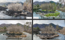
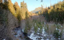
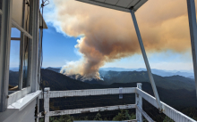
This photo was taken from the Roswell Point meadow on August 2, 2023.  It is looking across the upper Lookout Creek at the N side of Lookout Mountain and Lookout Ridge, where the fire is currently burning.  It may be one of the last photos taken of the north side of Lookout Mountain before the fire ignited on August 5. Smoke from the Bedrock fire is visible in the distance. Photo from Julia Jones, Oregon State University.

First posted August 16, 2023


A story map created by graduate student Alyssa Eklund contains videos, infographics and basic information about wildlife: “Nature's Hidden Encounters: Unveiling Wildlife Biodiversity - Large Wood Crossings at Lookout Creek, H.J. Andrews Experimental Forest, OR”. Much of the video footage and photos come from areas that are now within the Lookout Fire perimeter. This study shows that large logs laying across streams serve as important corridors to many different species of animals.

First posted August 14, 2023