Lookout Fire Updates 2023
September 29, 2023. Final Fire Updates Post.
As the fall rains have slowed the fire and shifted fire crews into repair efforts, our research community is shifting gears as well. We’re moving through shock and grief into acceptance, reflection, and curiosity: what will the places we have studied for decades look like, after the fire? What will we learn about how the forest recovers and changes? How might the fire change what we think about the forest, about ecology, and even about ourselves? We’ll re-tag trees in our long-term study plots, and document tree survival and mortality. We’ll study the fish and salamanders in the streams, and the birds in the trees. We’ll take the pulse of the trees and watch which seedlings grow into the forest anew. We’ll measure the changes in the sunlight on the streambeds, and we’ll track the chemistry of the stream water, through the seasons. We’ll track the weather. We’ll walk the old-growth trail, down to the cool waters of Lookout Creek. But we’ll do these things in altered landscape and as altered people. We’ll ask ourselves, “What’s the story, what can we learn from this?” And to answer that, to find the stories, we’ll bring all of the power of our research to bear: data and science for sure, but also our work in the arts and humanities, from poetry to painting to philosophical ethics, and beyond.
The Lookout Fire and the Andrews Forest were featured in last Sunday’s edition of the Seattle Times. The article, titled, “Decades of research burned in this Oregon forest. Now it could hold clues to wildfire mysteries,” by Lynda Mapes, touches on the forest and the community of people who have been studying and caring about the forest for decades. Thank YOU for being part of our caring community.
We invite you to join us in our recovery efforts: supporting graduate students whose work was impacted by the fire, replacing research infrastructure lost in the fire, studying the post-fire forest, and hosting artists and humanists. You can donate online, or contact the LTER Coordinator if you’d like more information on ways to support the program or to be added to our newsletter list.
Today’s is our last post on the Lookout Fire Updates page. Future information will be posted to our News and Events page. Here are a few resources:
- Follow our News and Events for update information on the fire, post-fire maps, and community events and meetings
- Read the full “A Look Before the Fire” series for snapshots into the kind of work that happens on site
- See our webcams for a window into the changing post-fire landscape
- Scan our photo gallery for images of the forest, before and after the fire. We'll post new photos as we receive them.
- Check the real-time weather data or download our research data, which is all made publically available.
- View our YouTube videos on fire in the forest and fire recovery efforts
- Follow the official Lookout Fire Facebook page and InciWeb Website
- Track closures, and the lifting of closures, on the Willamette National Forest notices website.
- And, finally, when the forest is open again, do visit, to see the trees and the streams and the salamanders and the birds, for yourself.
September 28
 The official InciWeb information lists the fire at 25,751 acres and 50% contained. "A half-inch of rain was received over the fire areas the last two days, furthering containment efforts and shifting focus to repair – the process of restoring disturbed areas to their natural state. Ongoing suppression repair work across the fire areas includes chipping and removing large amounts of woody debris, drainage work, erosion control, hand and dozer line naturalization and infrastructure repair. Although the fires are largely under control, considerable work remains." The Burned Area Emergency Rehabilitation (BAER) resource specialists began assessment of the Lookout Fire yesterday. Mark Schulze is part of that team. While suppression repair primarily concentrates on damages brought on by firefighting efforts, a BAER team concentrates on impacts caused by the fire itself. After the BAER assessment, a report and maps will be released following the analysis of their findings.
A Look before the Lookout Fire. Post 29: Fire as an Agent of Change
Forests, though they may appear timeless at first glance, are in a perpetual state of change. Beneath the canopy, fallen trees and regenerating seedlings remind us that forest life is exceptionally dynamic. At the Andrews, we have been monitoring the forest and recording its story of change for over 50 years. The hope of those with the foresight to start this project was that the forests of the Andrews would serve “as references for scientists of many disciplines in their future studies of these and similar forest communities” (Hawk et al. 1978). Now, over 50 years later, the long-term forest monitoring program at the Andrews continues to form the foundation for many projects in ecology, biogeography, and the humanities.
Today, the FOREG (Forests of Oregon Elevational Gradient) project, led by Marquette University professor Joe LaManna, is expanding these forest monitoring efforts. The FOREG project combines new monitoring with historical datasets to address fundamental questions associated with the maintenance of diverse forest ecosystems. Recently, this work has uncovered the role of species interactions in mediating species diversity – you can read more about it here. While many of our forest monitoring plots have been burned by the lookout fire, this represents a critical opportunity to learn more about how pre-fire forest structure and diversity influences post-fire environments. In the coming years, we hope to learn about the resiliency of forests to wildfire, how tree microclimates influence fire refugia, and how species interactions mediate diversity in regenerating forests.
Cole Doolittle, a graduate student at Marquette University, studies plant diversity in changing environments. He shared his work about plants and fire in a June 2023 LTER Network blog post, “The lessons wildfire can teach: destruction and resiliency after disaster.” As we begin to see the post-fire images of the Andrews Forest, and the changes to our carefully-studied, beloved places, it is some comfort to be reminded that, in Cole’s words, “wildfires play a leading role in sparking new life, working as agents of renewal to reimagine the composition of an ecosystem.”
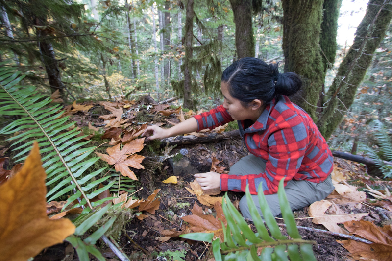
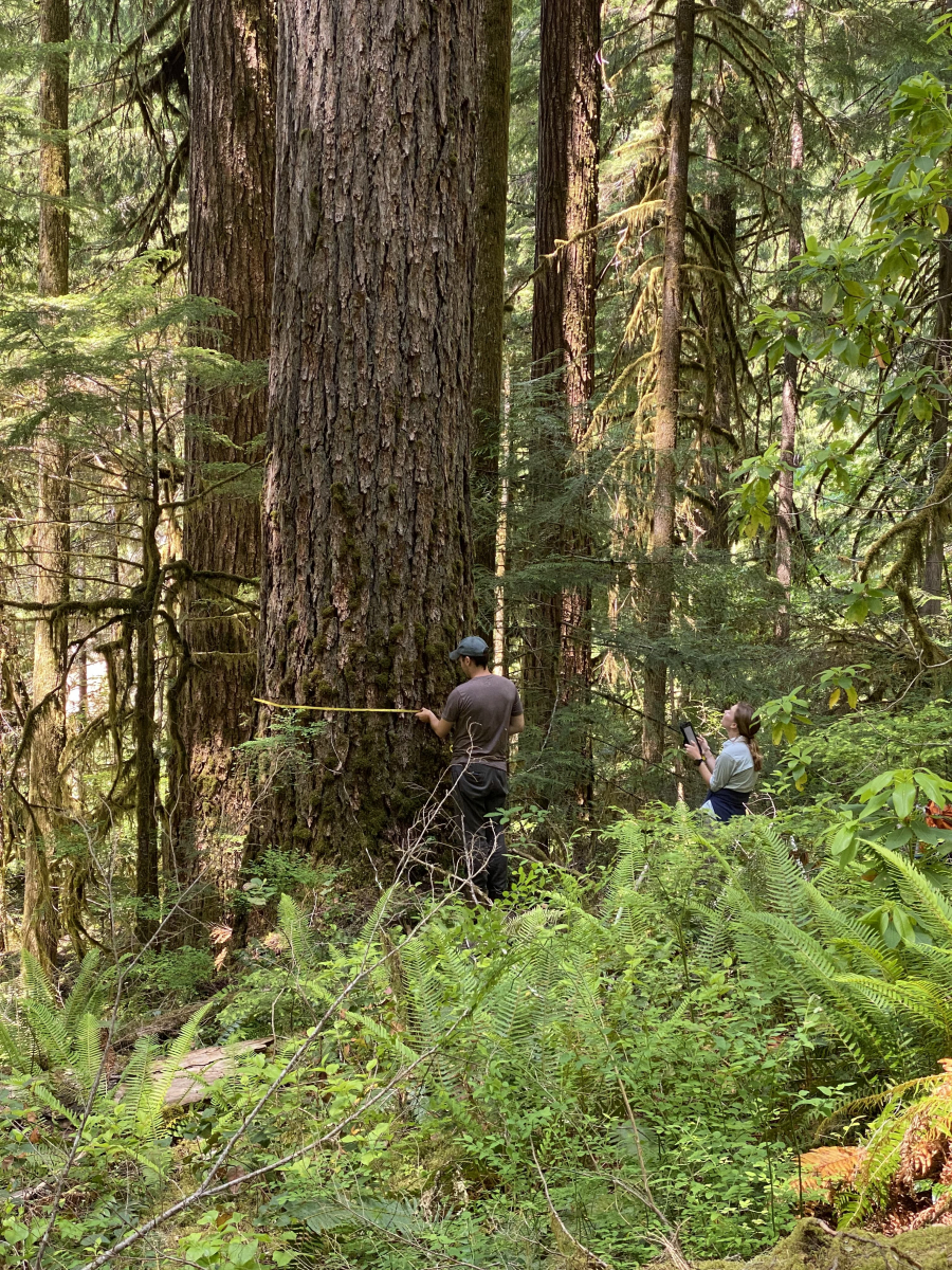 FOREG Technician Sol Zeigert (left) and Marquette University undergraduate student Grace Lindstrom (right) remeasure a Douglas-fir within one of the long-term forest monitoring stands now within in the Lookout Fire boundary.
September 27
Fire suppression repair and restoration efforts are underway. From InciWeb: "Resources are continuing to utilize chippers to process debris and vegetation left over from suppression efforts, and are working to transport trees and logs away from the fire area. Large amounts of woody debris were created in the process of suppressing these fires. The removal of this woody debris is as important and almost as extensive of an operation as the suppression efforts that create them." Burned Area Emergency Rehabilitation (BAER) team members will begin their study and assessment of the Lookout Fire areas tomorrow. A report and maps will be released following the analysis of their findings.
A Look before the Lookout Fire. Post 28: Words on Fire
The interagency Joint Fire Science Program (JFSP) funds wildland fire science and delivery of that information to help policy makers, fire managers, and practitioners. More than a decade ago JFSP leadership sought help from the Long-Term Ecological Reflections program to engage the humanities and arts to assist in this task by funding two projects: Words on Fire based in Corvallis and The Art of Fire based at the Bonanza Creek LTER site in Fairbanks, Alaska. The work is based in part on the premise of writer Leslie Marmon Silko that, “The way you change a human being and human behavior is through a change in consciousness that can be effected only through literature, music, poetry—the arts.” Recent fires in and around the Andrews Forest are stimulating new forms of inquiry; the 2020 Holiday Farm Fire triggered the art-science project Following Fire and now the Lookout Fire may prompt a revisit to Words on Fire.
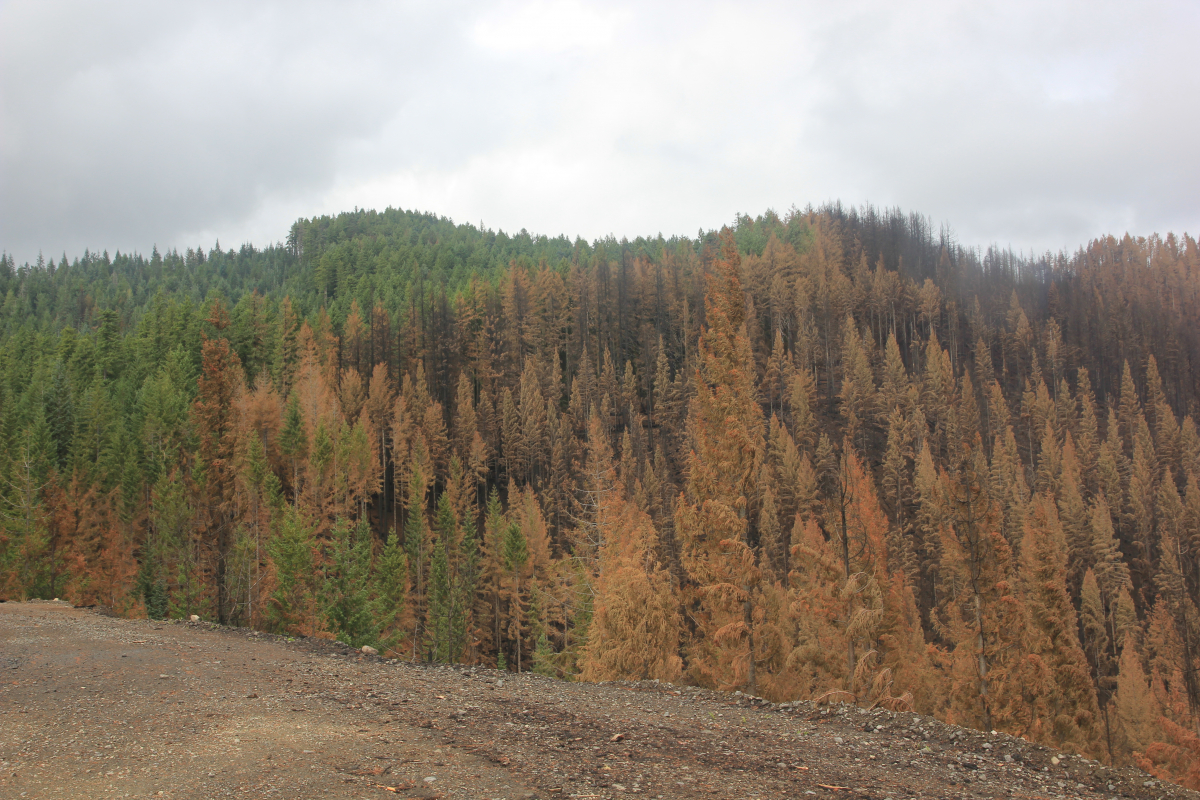 Images from within the HJ Andrews Experimental Forest reveal what one reasearcher said was, "what we expected, yet worse than we hoped." Large areas of forest, including old-growth, show 100% mortality, right next to areas that are 100% live. We'll continue to share images, information, and maps as they become available.
September 26
 From InciWeb: "On the Lookout Fire, fire crews will continue to chip woody vegetation removed as a fuel source during the suppression efforts. Additionally, logs cut during the firefighting efforts continue to be hauled from the fire’s footprint. Suppression actions that need to be repaired are frequently identified even while those actions are occurring. The process to complete suppression repair efforts involves close coordination between the Resource Advisors and the firefighters during, and following, firefighting efforts. Once the dozer lines, handlines, or other disturbances are identified, they are tracked on a map. As crews work to repair damage from the firefighting efforts, those areas are classified as either in progress or completed. Once firefighters improve the conditions on the ground to a pre-fire state, the Resource Advisors inspect the repair efforts before marking them as completed." Burned Area Emergency Rehabilitation (BAER) team members will begin their study and assessment of the Lookout Fire burned areas on Thursday, September 27. A report and maps will be released following the analysis of their findings.
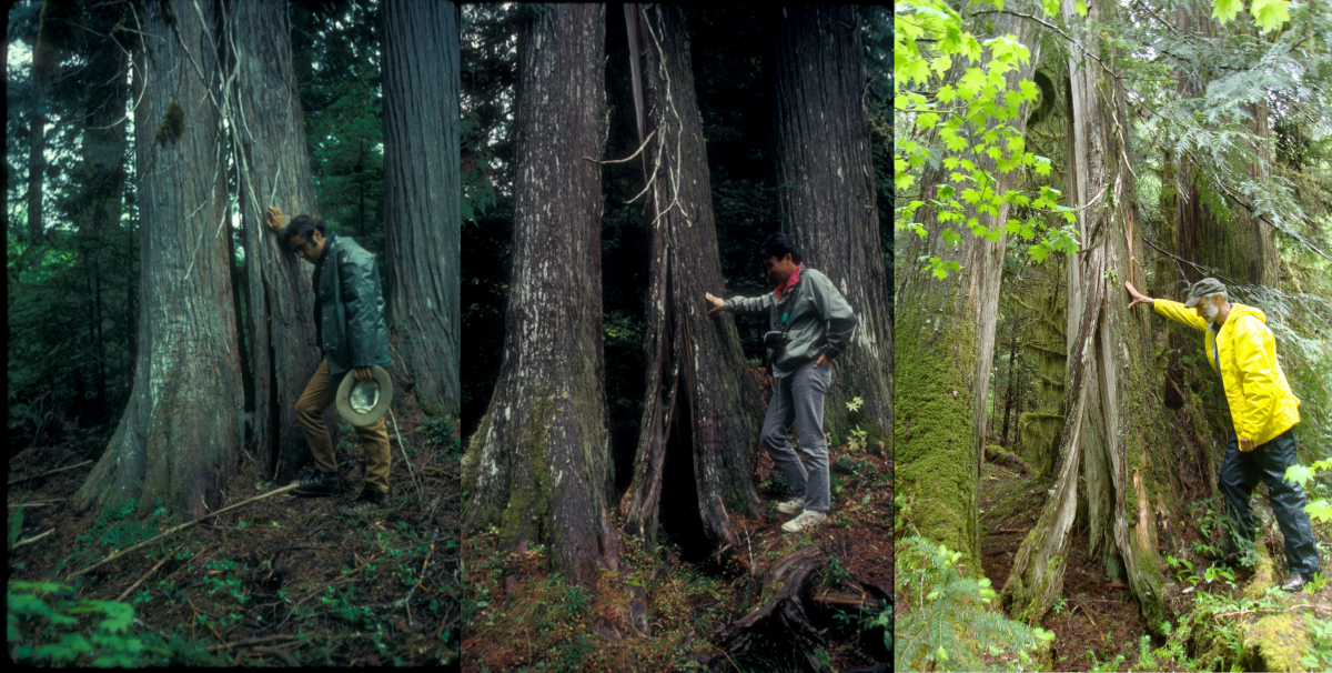
A Look before the Lookout Fire. Post 27: Earthflow and the Split Tree
The Lookout Earthflow is a medium-sized (ca. 800 m long and 100 m wide), slow-moving landslide located about 1 mi east of the lower Old Growth Trail trailhead. It was discovered in 1974 during mapping of the geology and geomorphology of the Andrews Forest, and measurements of its movement began at that time, using various techniques. Its movement rate of cm/yr is fast enough to create disruption of the 1506 road and the forest riding atop it, but slow enough that the forest is largely intact and just riding along. One distinctive tree – The Split Tree – has been a popular show-and-tell site. This photo shows the progress of splitting and the caring attention of retired College of Forestry prof Bob Beschta in 1974, University of Hokkaido prof Futoshi Nakamura in 1992, and Fred Swanson in 2017. When discovered in 1974, the tree had already been splitting for many decades, based on tree-ring analysis. We’re curious to see if this tree and others on the earthflow survived the fire. Extensive tree death in the contributing watershed area, both on and upslope of the earthflow might increase the delivery of water due to reduced evapotranspiration, and thereby increase its movement rate into Lookout Creek at the earthflow toe. During the 1964 flood many small landslides at the toe resulted in a surge of logs and boulders about a mile down Lookout Creek, which lodged in the vicinity of the log bridge over Lookout at the lower end of the Old Growth Trail. The numerous snags at that site are trees killed by deposition from that event.
September 25
 With the cool weather and wetting rain further decreasing fire behavior to creeping and smoldering, even extinguishing some areas of remaining heat within the fires’ perimeters, most firefighting resources are focused on suppression repair. InciWeb shares the following repair operations occurring within the Andrews Forest boundary: "This includes, Hazard Tree Falling, chipping, dozer/handlines, log skidding, log processing, log hauling, road repair, culvert clearing, pulling structure wrap and backhaul of pumps, hose, sprinkler kits, etc ... Monitor fire as it progresses towards line." And, "Only two miles of the nearly nine miles of handline constructed on the Lookout Fire have been repaired thus far." "Additional suppression repair work includes removing supplies firefighters used in the suppression efforts on each of the fires. To date, firefighters have backhauled more than four semi-truck loads of supplies used in the field – including 30 miles of hose that were deployed in the event it was needed." At our headquarters facilities, hoses, sprinklers, and pumps were removed yesterday, a sign that the fire incident team feels confident that the headquarters structures are no longer in danger of burning. Phew!
As the intensity of the fire abates, we have more time for reflection and wondering about how the fire played out on the landscape.
A Look before the Lookout Fire. Post 26: A canopy view of the lives of birds
Nina Ferrari studies birds that spend their breeding season (spring and summer) in the canopies of tall trees. Specifically, Nina, a PhD student at Oregon State University, is trying to understand what factors contribute to the vertical partitioning of birds in the forest canopy. For a close-up view, Nina takes to the trees. On a normal field day Nina will use climbing harnesses and rope to ascend hundreds of feet into the forest canopy. She instruments each tree with recording units to document bird songs and microclimate data loggers. Over time, these data will give insights into patterns of vertical space use in birds and what contributes to those patterns (microclimate, competition, vegetation structure, etc.). Climbing huge old growth trees takes time, energy, and courage, and each climb gets one up close and personal with that tree. After multiple climbs over a field season, Nina has a few favorite trees on the landscape. “Big Mack”, a 250-foot hulk of a Douglas fir, and one of Nina’s most iconic trees with its leaning trunk and sprawling epicormic branches, grows in the Mack Creek watershed, which was burned early in the Lookout Fire. Nina holds grief for the loss of her favorite trees and areas the forest that burned and at the same time she holds excitement and passion for her research in understanding how bird species respond to the impacts of climate change, including fire. To see images of Nina’s work, and views from the treetops see the online photo album.
 Sunrise at a bird survey point near Saddle Creek. Image by Nina Ferrari.
September 24
 The fire is listed at 25,751 acres, the same as yesterday. InciWeb reports: "With the onset of a sustained pattern of cooler, wet weather, firefighters have shifted their focus to accomplishing the substantial task of suppression repair across all five fires. Despite the increased relative humidity and chances for rain, fire will continue to consume decaying vegetation covering the forest floor, downed logs, and heavy concentrations of slash in interior portions of the fire before accumulated rainfall amounts extinguish some of the remaining heat. The incident management team, working closely with the Resource Advisors, have developed a geo-referenced database to track the substantial suppression work that needs to be completed as the fire management shifts from fire suppression to exclusively suppression repair. Logs generated from cutting trees on the Horse Creek Fire and the Lookout Fire were removed from the fire footprint. In advance of the rain that began overnight and is expected to persist throughout the week, firefighters placed emphasis on cleaning culverts and other water diversion infrastructure to ensure that they are clear for the wetting rains. On the Lookout Fire, crews have a significant amount of suppression repair remaining to complete. To date, firefighters have completed suppression repair of 6.4 miles of the 32 miles of dozer line created during suppression efforts."
The Fire Behavior Assessment Team (FBAT) is a unique US Forest Service rapid response fire crew that specializes in real-time monitoring of fire behavior on active fires. An FBAT team is active at the HJ Andrews Experimental Forest. Ben Nash, a USFS hydrologist who works with the Andrews Forest program, is serving with FBAT and shared new videos from the FBAT work on our YouTube channel.
September 23
 The fire is 25,751 acres, creeping and smoldering. InciWeb reports "With minimal fire activity and precipitation moving into the region, the Lookout Fire is not predicted to grow much beyond its current footprint and efforts have shifted predominantly to patrol, monitor, and suppression repair. This strategy is based on the improved conditions, hard to access areas in the northern portions of the fire, and a reduced threat to people and property." And, "Across the Lookout Fire, repair work is taking place within all divisions, including hauling logs and chipping in the northern portion of the fire." Today will be the last dry day in the forecast as a cooling trend sets in with temperatures in the mid 50s to low 60s. Showers are possible overnight leading into consistently rainy days through much of next week.
NEW: Images and videos from the Lookout Fire
See Lookout Fire photo album for images of the forest, the fire, and fire supression activities. And see our YouTube playlist for a video of the fire burning through the understory, and a video of a drive along the fireline starting at Rd 320.
September 22
 The fire is 25,659 acres with minimal fire movement. In the northern area of the Lookout Fire, within the Andrews, a tub grinder has been deployed. "This specialized equipment processes woody debris, turning it into mulch to reduce the orientation of fuel and, therefore fire behavior potential." Burned Area Emergency Rehabilitation (BAER) activities and fire suppression repair work is underway. A strong storm system with wetting rain is expected towards the end of the weekend and into the beginning of next week. We anticipate the rains to slow the fire further, and to bring water into the streams.
A Look before the Lookout Fire. Post 25: The Cascade torrent salamander
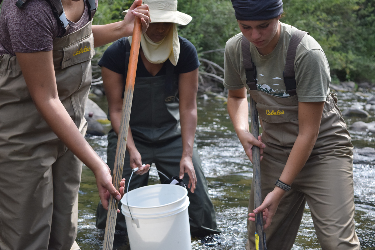
The seeps and cold, fast-flowing headwater streams in the Andrews Forest are home to one of the Pacific Northwest's most charismatic, and yet little understood, species: the Cascade torrent salamander (Rhyacotriton cascadae). The entire family is endemic to the PNW, and two of the four species are currently being considered for listing under the Federal Endangered Species Act. These salamanders are biphasic, with a larval form that can take up to 5 years to metamorphose into a terrestrial form that is still highly sensitive to desiccation and changes in temperature. Despite this, the salamanders can be found in intermittent streams, as they are thought to utilize the hyporheic zone, where groundwater and subsurface stream water mix. The impacts of climate change will likely result in a significant reduction in available habitat to the salamanders, and their ability to disperse to suitable aquatic environments will be crucial to their long-term survival. A landscape genomics study at the Andrews Forest is focused on answering several questions: Is movement tied completely to streams, or do adults cross forest and ridges to move between streams? What does dispersal look like within, between, and among stream networks? What landscape features facilitate or impede movement?
Graduate student Christopher Cousins is leading the study. He shares: “Our project was cut short due to the Lookout Fire, but we are hoping that our existing samples and data will be able to address our questions. As part of our sampling, we visited sites affected by the 2020 Holiday Farm Fire. Although the burned sites looked rough, we were able to find multiple torrent salamanders at streams impacted by the fire, by searching deep in the stream substrate. We found salamanders of multiple age classes, indicating that not only did salamanders survive the fire, but that reproduction had occurred since. It's likely that torrent salamanders can weather fire events by moving vertically in the stream, using the same strategy they use to live in intermittent streams. Although my heart aches for the Andrews and the forest as it burns, knowing that Cascade torrent salamanders will ride out the fires in subsurface refugia provides a sense of relief.”
Check out Christopher Cousins’ Instagram to see his stunning, up-close images of salamanders and other wildlife.
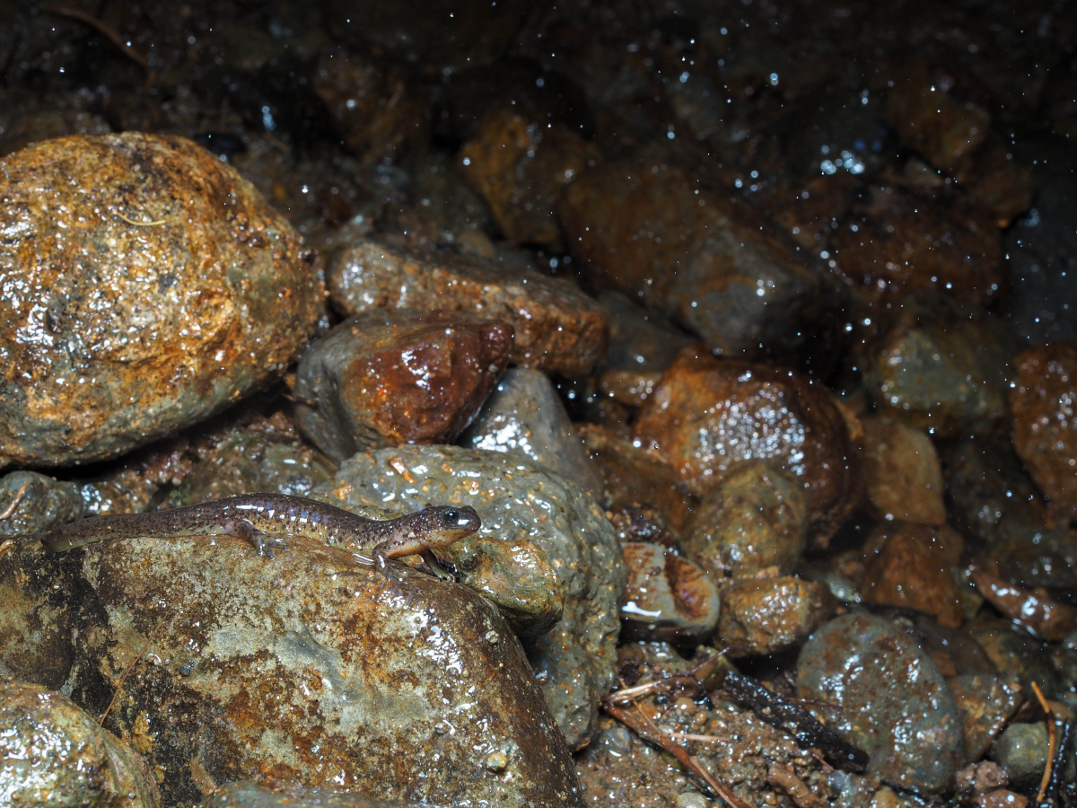 Cascade torrent salamanders may find refuge from the fire by moving deep within the rocky substrate along streams. Image by Christopher Cousins.
September 21
 Today's InciWeb report lists the fire at 25,659 acres and 50% containment. Within the HJ Andrews Experimental Forest the fire is continuing to grow, albeit slowly, and is still considered uncontained at the northern edge. The western edge of the fire, closer to headquarters, is contained and considered a low risk for spread. Firefighters are engaged in suppression activities along the north side of the Lookout Fire, southeast of Carpenter Mountain. Even as suppression efforts continue, crews are beginning repair work. "Due to the large size of the Lookout Fire, suppression repair efforts are expected to continue for the weeks ahead. These activities are initiated as soon as it is safe to do so – often even when firefighters are still suppressing the fire. Firefighters continue to work closely with the Resource Advisors to mitigate the damage to natural and cultural resources caused by the emergency suppression efforts. Some of the continued activities being completed include stabilizing soils along dozer and handlines constructed as control features to limit fire growth, ensuring culverts and ditches are cleared for the coming rains, and removing woody debris accumulated on the forest floor as it was removed to starve the fire of available fuel."
This linked PDF of annotated photos shares images taken on September 20, 2023, from the rock quarry site on Road 130, with a focus on the Lookout Ridge and the burn mosaic from the wildfire and firefighter burnout operations.
September 20
 Today's InciWeb report lists the fire at 25,515 acres and 50% containment. Firefighters’ main focus continues to be along the northern edge of the fire, south of Carpenter Mountain, and on the 320 road, along McRae Creek. The increased fire activity over the past week burned more of the McRae Creek basin, including research locations for the Drought Experiment, NEON, and a study on how forest canopy affects light on streams which, in turn, impacts ecological processes of streams.
A Look before the Lookout Fire. Post 24: Forest Canopy Light and Streams
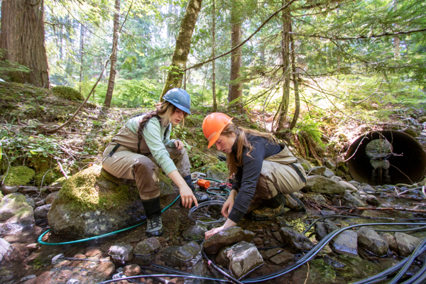
Forests and streams are inextricably linked in our western Oregon landscapes, so the significant changes to the forest resulting from the fire will inevitably affect the streams. As research from Mack Creek in the Andrews Forest has demonstrated, wood input from the forest fundamentally shapes the geomorphology and habitat of streams. In McRae Creek, OSU professor Dana Warren and his team have been exploring how the riparian forest canopy impacts light on streams which, in turn, affects ecological processes in those streams. They initially looked at how historic timber management affected light availability in streams and the impact of that light availability on nutrient limitation and aquatic primary production. They also created an experimental canopy gap over the stream in one of the tributaries to McRae Creek and quantified how fish, invertebrates, temperature, primary production and nutrients changed with the creation of a light patch. The impacts of the Lookout Fire will far exceed the impacts of the experimental small gap and will re-open canopies in areas of past clear-cuts that had regenerated to dense stands of alder and fir. In the coming years we will learn about the resilience of streams to the loss of riparian forests and how ecosystem processes and aquatic biota respond to loss of forest canopy cover and changes in stream hydrology following fire. See our online album: images of the gap study in 2017.
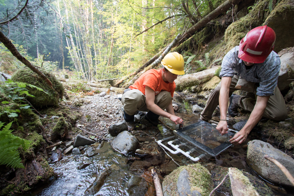 OSU graduate student, Allison Swartz (left) and undergraduate student Cedar Mackaness (right) measure primary production using stream metabolism chambers in a tributary of McRae Creek in 2017.
September 19
 Today's InciWeb report lists the fire at 25,515 acres and 50% containment. The majority of the uncontained line is within the boundary of the HJ Andrews Experimental Forest. Reports from fire crew divisions working within the Andrews are: "Continue prepping alternate lines along the 350 rd and monitor fire. Continue to improve line construction from the 325 spur to Carpenter Rd. Monitor fire as it progresses towards line, burning line as needed." And, "Resources will work to assess the need to pick up fire that crossed the direct line. Fire is still within our main line. Air resources are being utilized to support operations. Monitor fire as it progresses towards line, burning line as needed." "Firefighters observed moderate fire behavior with flanking, backing and single tree torching. Continued isolated areas of fire activity today with active backing and single tree torching. Smoke production increased today. Predicted decrease in fire behavior and smoke production in next few days as weather transitions slowly to cooler and wetter conditions. This cooling trend is expected to persist through the week accompanied by potential rain within the next 72 hours."
A Look before the Lookout Fire. Post 23: Taking the Pulse of Trees
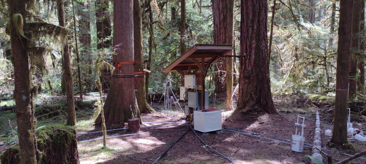
How do you take the pulse of a tree? High-precision dendrometer bands like the ones pictured here can measure daily fluctuations in water balance of a tree bole, in addition to its seasonal growth. The summer drought experienced by trees at the Andrews Forest is one of many stressors that has been increasing over time with climate change. While the tree species that have thrived in this landscape for millennia are adapted to wet winters and dry summers, prolonged drought combined with heat waves can stress even the drought-tolerant Douglas fir trees and lead to early shut down of stem growth. An extreme example of this was the 2021 June heat wave that caused many trees subjected to record high temperatures to cease diameter growth abruptly and drop heat-damaged foliage. In the dry season we see tree stems contract during the late morning and afternoon as water is moved from the stem to foliage to meet the tree’s transpiration needs and then expand overnight as soil water replenishes stem water, at least partially (near real-time graphs of some of the dendrometers are posted here). Over the course of a strong dry season like we are experiencing in 2023 even the nighttime maximum circumference decreases from day to day, as growth ceases and stem water cannot be fully recharged. One downside to this type of dendrometer: cables everywhere. And cables and fire do not mix well. So far nine of our dendrometer plots have been visited by the Lookout Fire; we don’t expect the dendrometers and cables have made it, but we hold out hope for the trees.
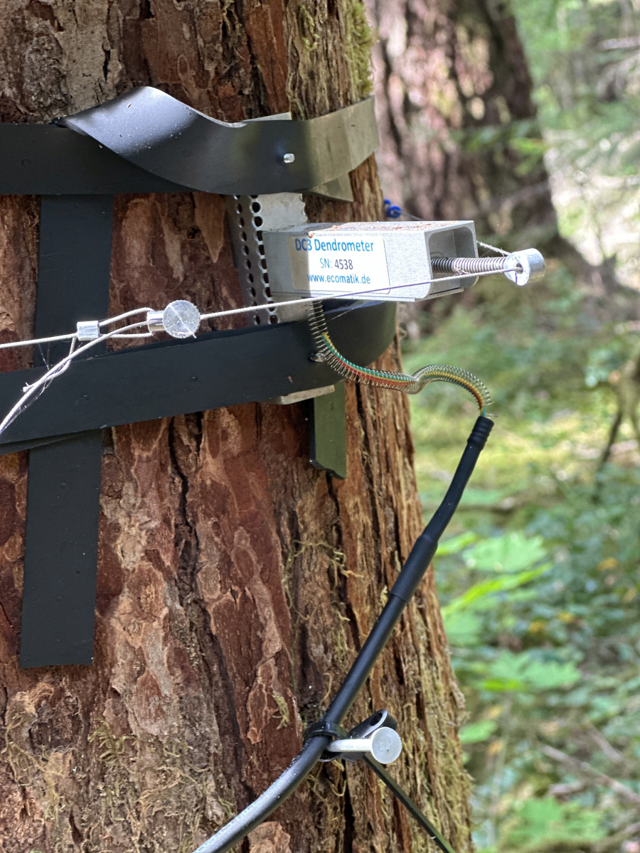
 Dendrometer bands are fitted around the trunk of a tree and measure expansion and contraction. Image courtesy of Willamette National Forest, Alan Thornton, USFS.
Research equipment is connected through cabling, and connects to data loggers, batteries, and even wireless transmitters that send the data to researchers in real time.
September 18
 From InciWeb: “Firefighters held containment lines as fire activity increased Sunday afternoon. Helicopters and Fire Bosses (single engine fixed-wing air tankers) dropped water on the northern perimeter [within and bordering the Andrews Forest]. More seasonable cooler weather is returning to the fire area today, which is expected to moderate fire activity through the week.”
A Look before the Lookout Fire. Post 22: Fire and Forest Change
The Lookout Fire and initial forest responses may be the current prime example of climate change impacts in the Andrews Forest, as anticipated more than 30 years ago. In a 1992 paper, Andrews Forest researchers predicted that, “the most rapid and extensive biotic changes in forests from climate change will be caused by altered disturbance regimes. Disturbances create the conditions for change in ecosystems, effectively doing the work of eliminating the established forest with its inertia, or tolerance of altered climate conditions. … Increased frequency of fire is certain under the climate change scenario, and greater intensities are probable” This paper goes on to say, “the most environmentally sensitive stage for western tree species is at the time of seedling establishment.” The predictions of the 1992 paper seem to be playing out here and now: climate warming may be enhancing wildfire regionally, and it also may influence forest succession after wildfire. Ongoing work by Andrews Forest researchers on vegetation response to fire is poised to interpret forest response to simultaneous increased fire and warming.
September 17
 From InciWeb: "As the current warming and drying trend continues through the weekend, the fire is burning more actively and producing visible smoke columns. This increase in fire behavior is occurring within containment lines on the northern portion of the fire near Carpenter Pass and poses no immediate threat to the communities along the McKenzie River corridor. Unhealthy levels of wildfire smoke observed near the fire area are the primary concerns from this uptick in fire activity. Firefighters continue to hold established containment lines to minimize fire spread to the west, south and east. Helicopters are assisting ground resources with water drops to cool down areas of heat and limit fire growth. One last afternoon of elevated fire weather concerns is expected today, mostly due to low relative humidities and elevated temperatures. Starting Monday, a cold front will move into the region bringing stronger onshore flow that will increase cloud cover, lower temperatures and boost relative humidities."
Size: 24,692 acres. Containment: 50%
September 16
 The InciWeb reports: "Fire activity increased Friday with temperatures in the low 90s and lower humidities. As a result, there was more smoke in the area until the inversion lifted in the early afternoon. Today’s forecast of hot and dry weather will again result in increased fire behavior. Firefighters are holding the containment lines. Alternate containment lines are being prepped along the northwestern edge of the fire [within the Andrews Forest], and small-scale burnout operations are being conducted to remove fuels between roads and the main fire. Containment lines to the north are being improved. Air operations will be active in supporting firefighters on the ground with water drops."
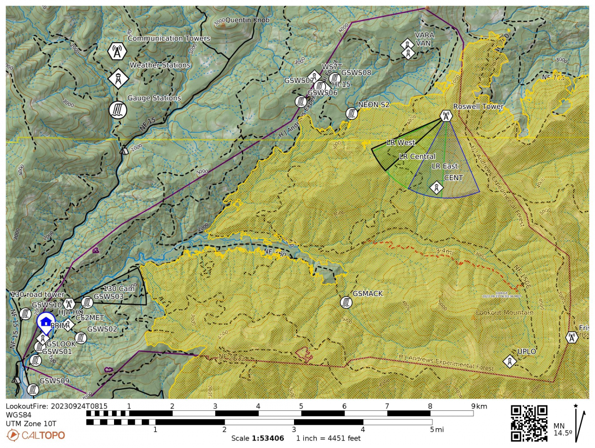
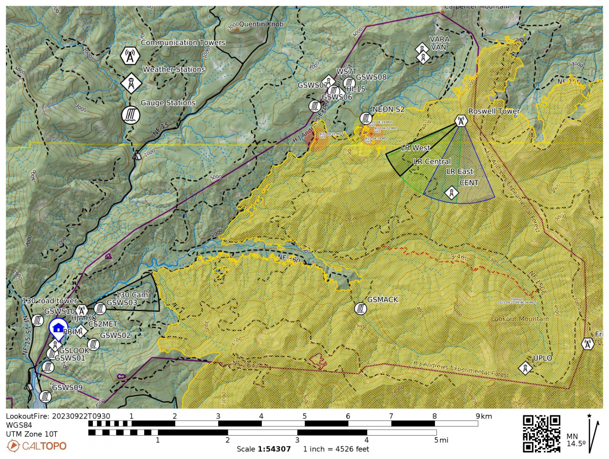
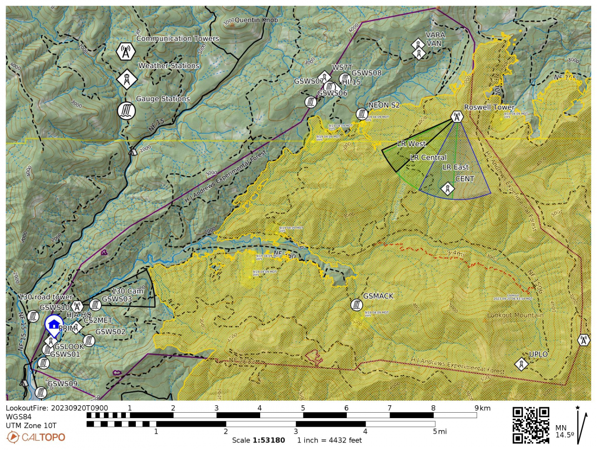
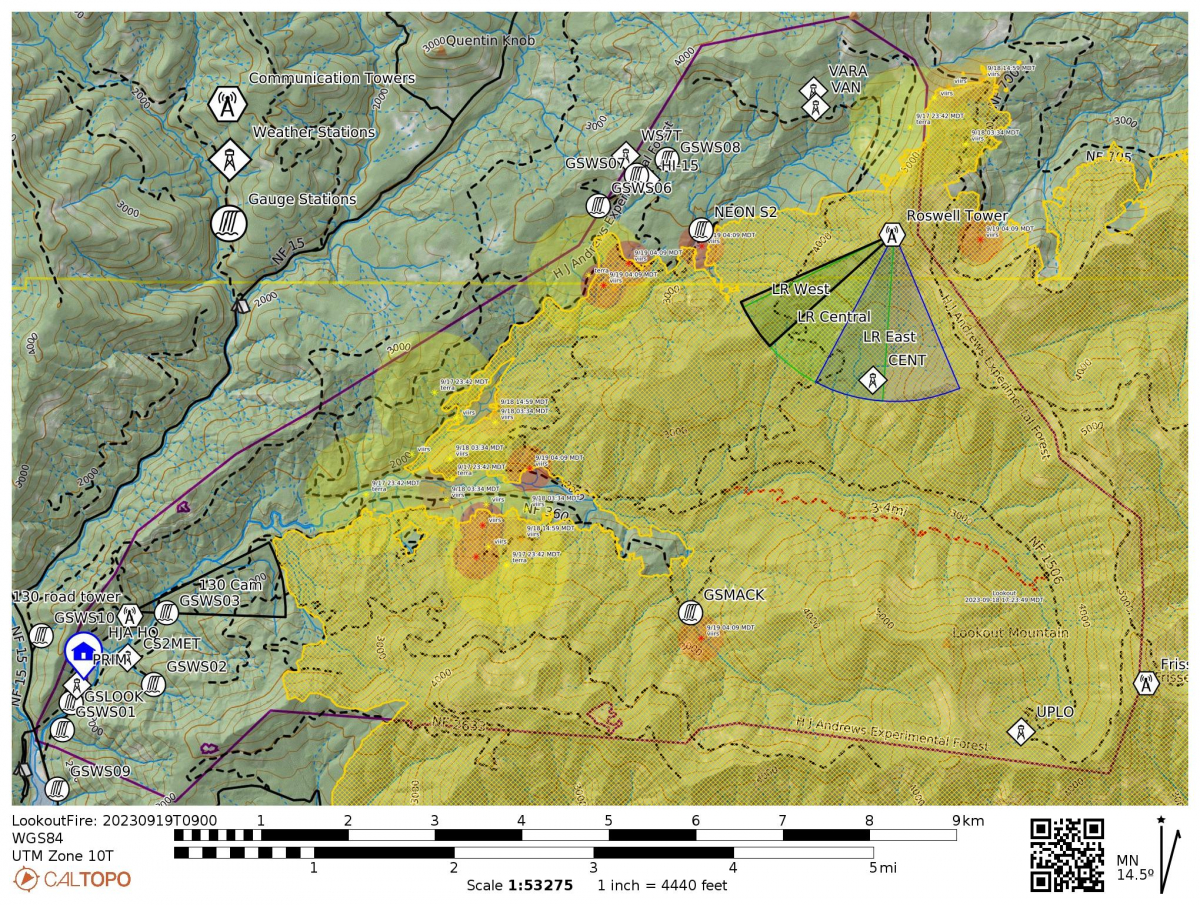
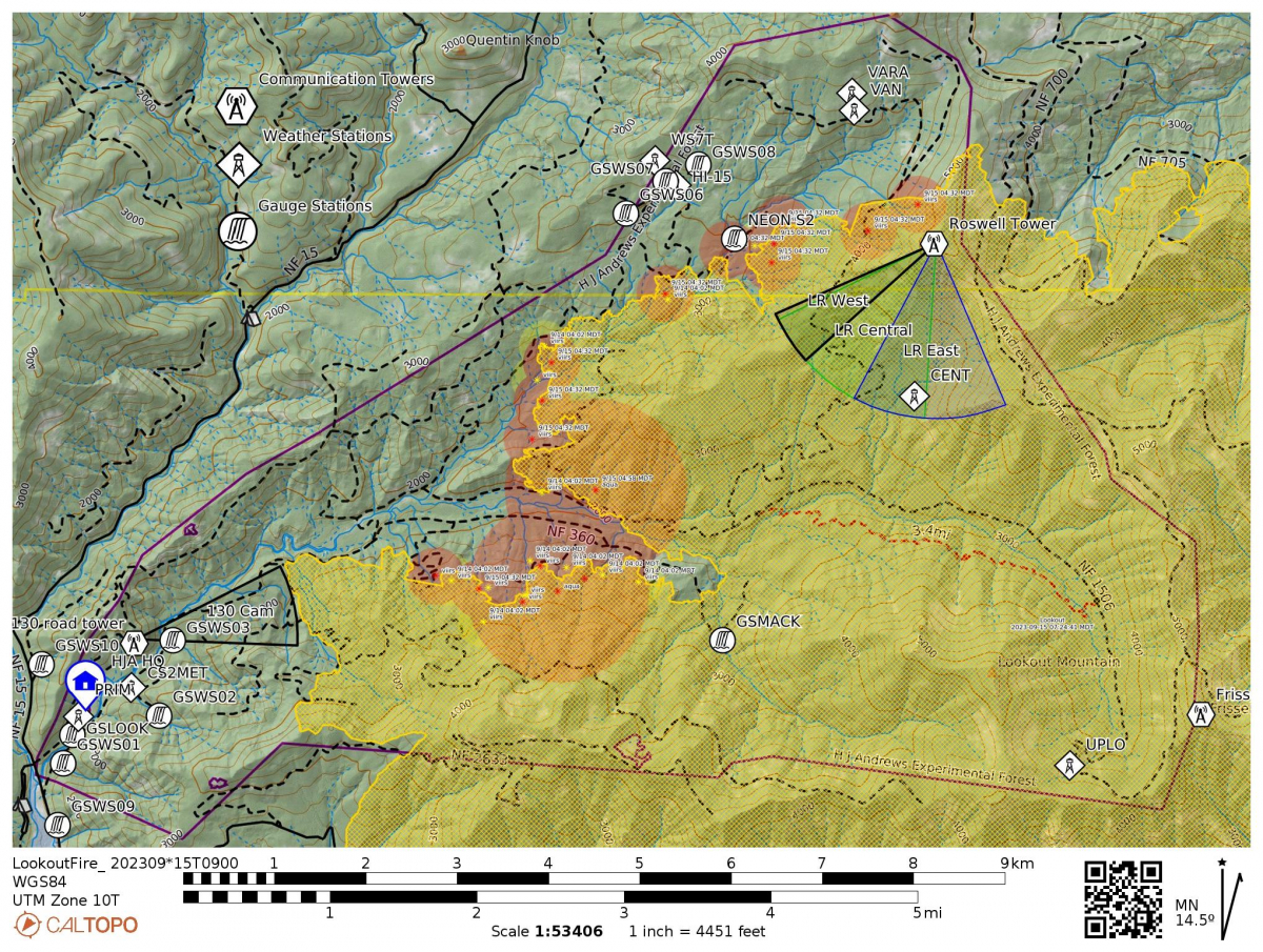
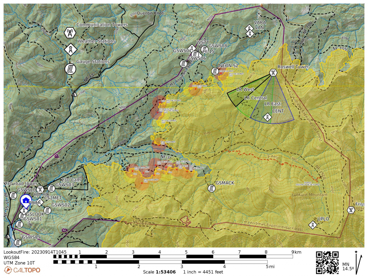
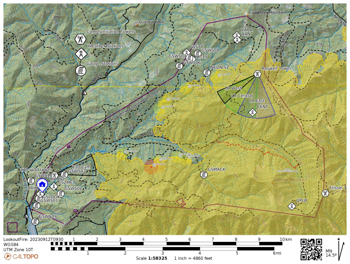
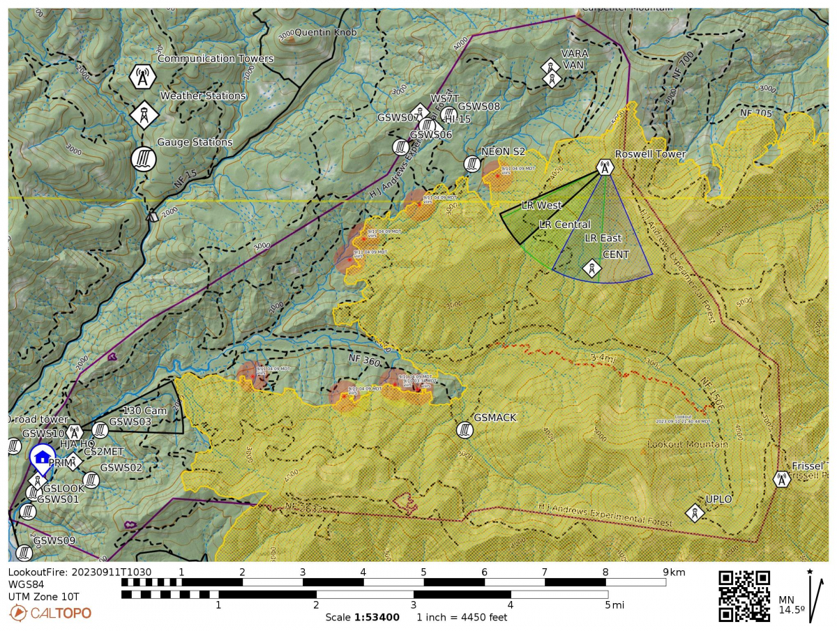
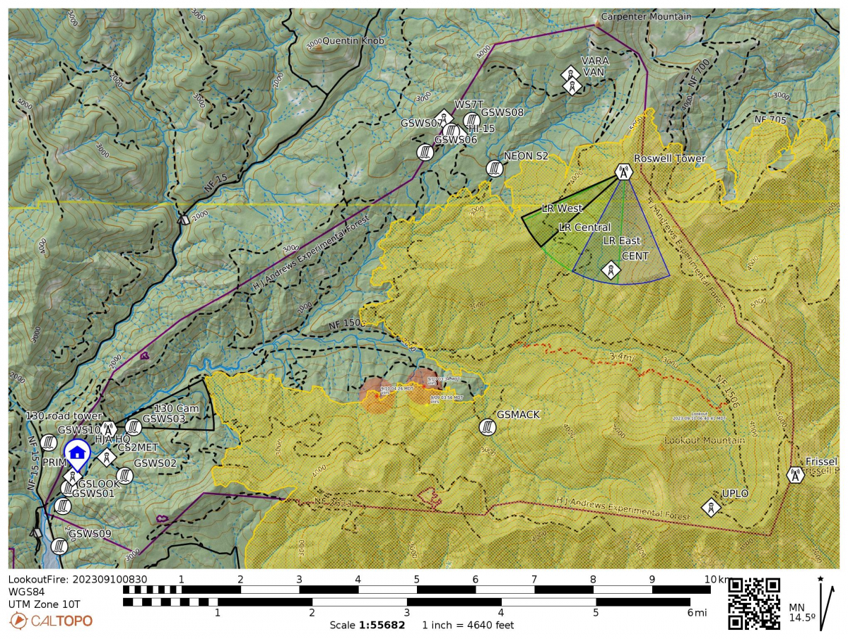
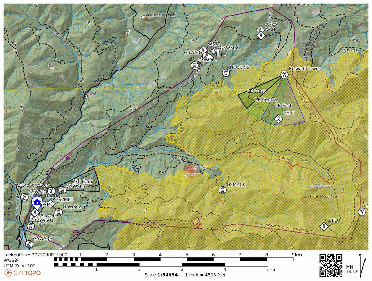
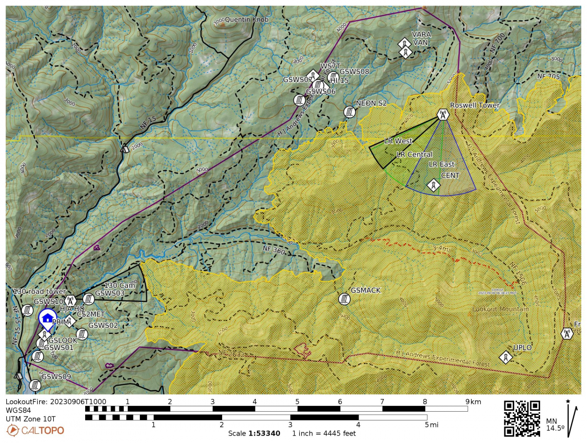
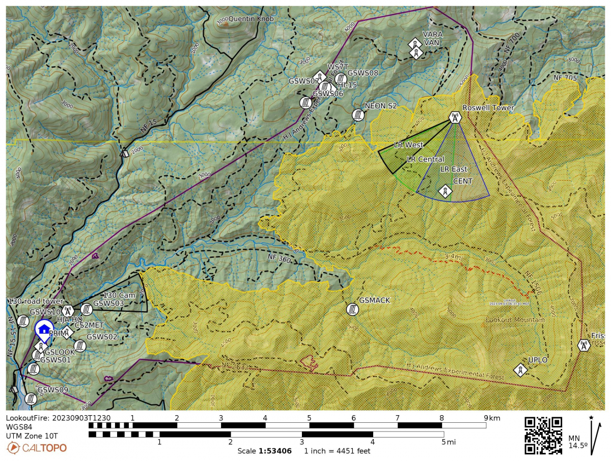
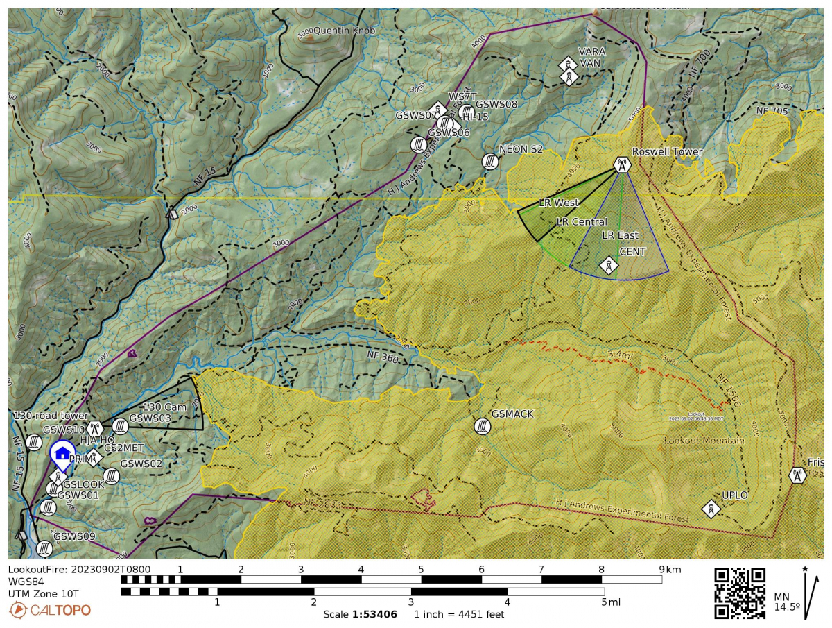
The new fire activity is noted on the map. Red dots are most recent heat detections (less than 12 hours), orange (12-24 hours), yellow (24-48 hours). The dark purple line, in the rough shape of a sideways heart, is the boundary of the H.J. Andrews Experimental Forest. Stream gaging stations and radio towers with webcam view cones are also noted on the map. The headquarters site is noted by the blue icon in the bottom left.
Webcams on the Andrews show thick smoke, even at headquarters. See links at the top of the webcams page for timelapse videos.
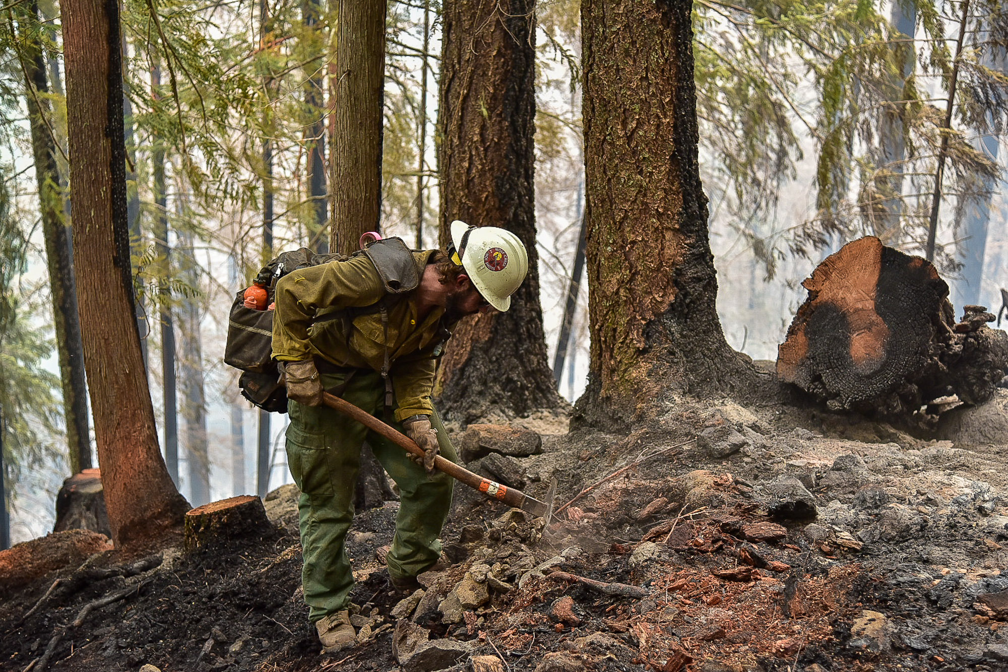
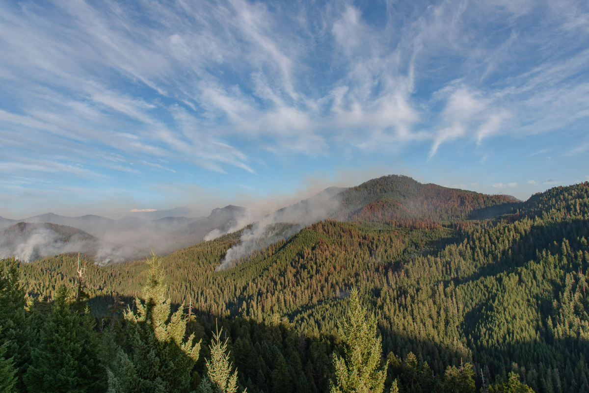 Photo of a Wolf Creek Hotshot mopping-up along a handline on a steep slope above FSR 465 and Watershed 3. Photo by Benjamin E. Nash, USFS.
View of Lookout Ridge from FSR 130. Note the mosaic of burn severity across the landscape. Photo by Benjamin E. Nash, USFS.
September 15, afternoon
A new post on the Lookout Fire Facebook fire features our research forest!
NEW! Drone footage over the McRae Creek Drainage, taken Sept 13, 2023:
September 15
 The InciWeb reports: "The Lookout Fire experienced pockets of increased mild to moderate fire activity due to the warmer temperatures and lower humidity levels in the region. Crews strengthened and tested the primary and alternate containment lines and equipment. Foot and vehicle patrols continue to be vigilant while monitoring any active pockets of fire. Expect elevated temperatures and lower relative humidity with the potential for critical fire weather conditions into Saturday, with highs in the upper 80s." Size: 24,644 acres. Containment: 50%. Personnel: 618. Resources: 25 engines l 12 crews l 6 bulldozers l 23 water tenders l 5 masticators l 3 helicopters l 2 skidders.
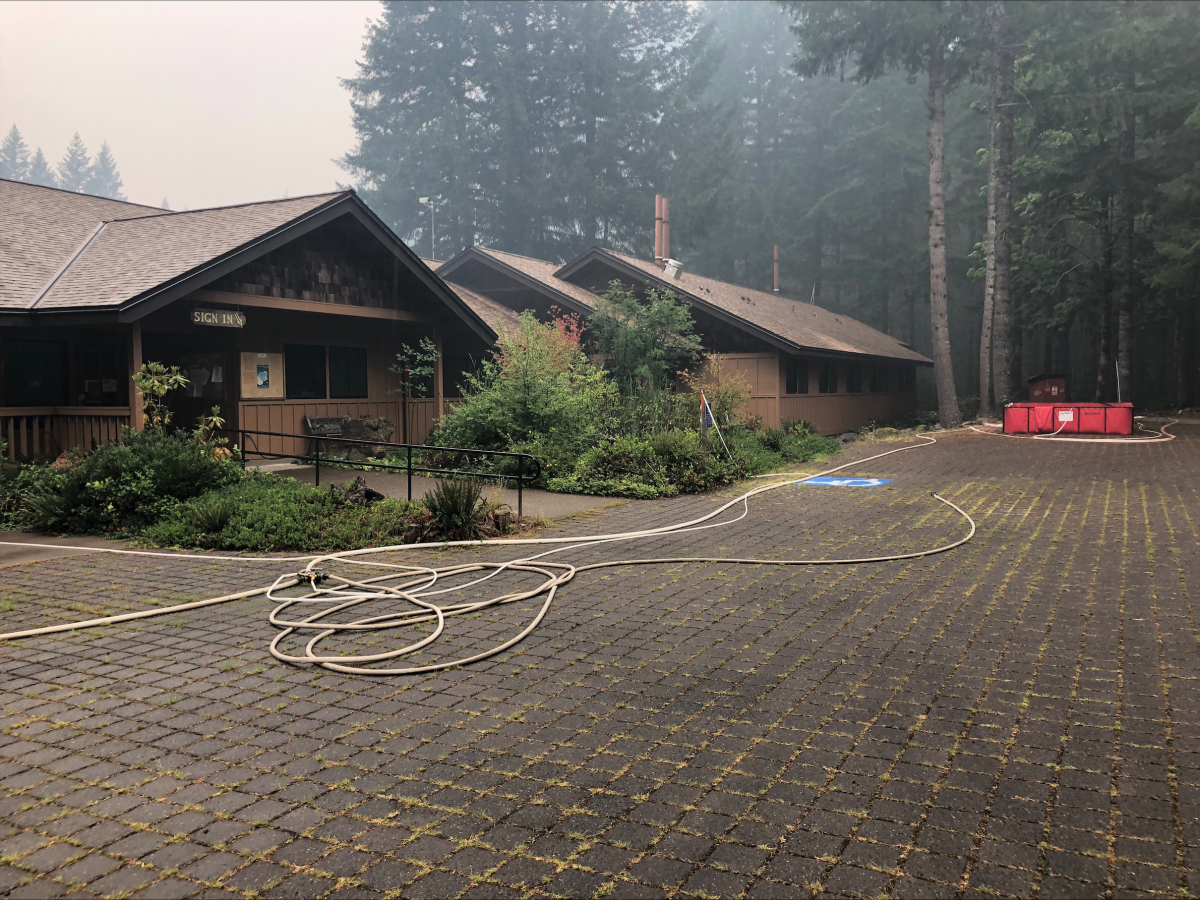
 Fire crews set up water holding tanks, pumps, hose, and sprinklers around the entire headquarters facilities.
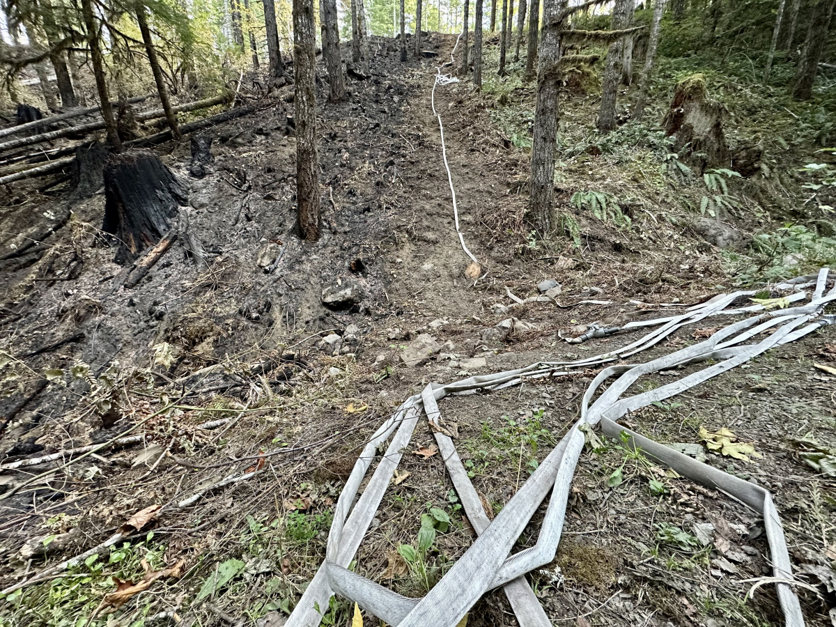
A fire containment handline involves removing vegetation and digging down to bare soil, installing fire hose, and burning off forest detritus and low vegetatoin on the fire-facing side of the line (left, in photo). The idea is that if the fire approaches the line it will not have the fuels to continue moving.
September 14
 Increased fire activity and smoke returned with hotter temperature, lower humidity, and increased winds. Today the Lookout Fire is reported at 24,610 acres and 50% containment. InciWeb reports: “Crews continue to construct line and improve roads on the northern portion of the fire where fire activity has picked up. Today will continue the warmer and drier trend along with a light easterly flow. Tomorrow will continue to trend warmer, drier, along with light easterly flow bringing another day of elevated fire weather concerns."
A Look before the Lookout Fire. Post 21. Wildfire and Wildlife
What wildlife lives in the HJ Andrews Experimental Forest, and what do those animals do in a wildfire? Marie Tosa, a PhD graduate student at Oregon State University, conducted a camera trap study and scat study of mammalian carnivores in and around the Andrews Forest from 2017-2019. Marie’s surveys detected a diverse array of carnivores including cougars, black bears, coyotes, raccoons, opossums, gray foxes, mink, short-tailed and long-tailed weasels, striped skunks, and Marie’s favorite, western spotted skunks. Many of these carnivores in the Oregon Cascades have large home ranges and are territorial, so they exist at low densities. The direct impacts of wildfire on mammalian carnivores are not well understood, but wildlife in this area are likely resilient and adapted to wildfires that burn at low and mixed severities. Large carnivores can typically escape fires by moving out of the fire footprint and smaller carnivores can find fire refugia, escape to underground burrows, or climb high into the canopy.
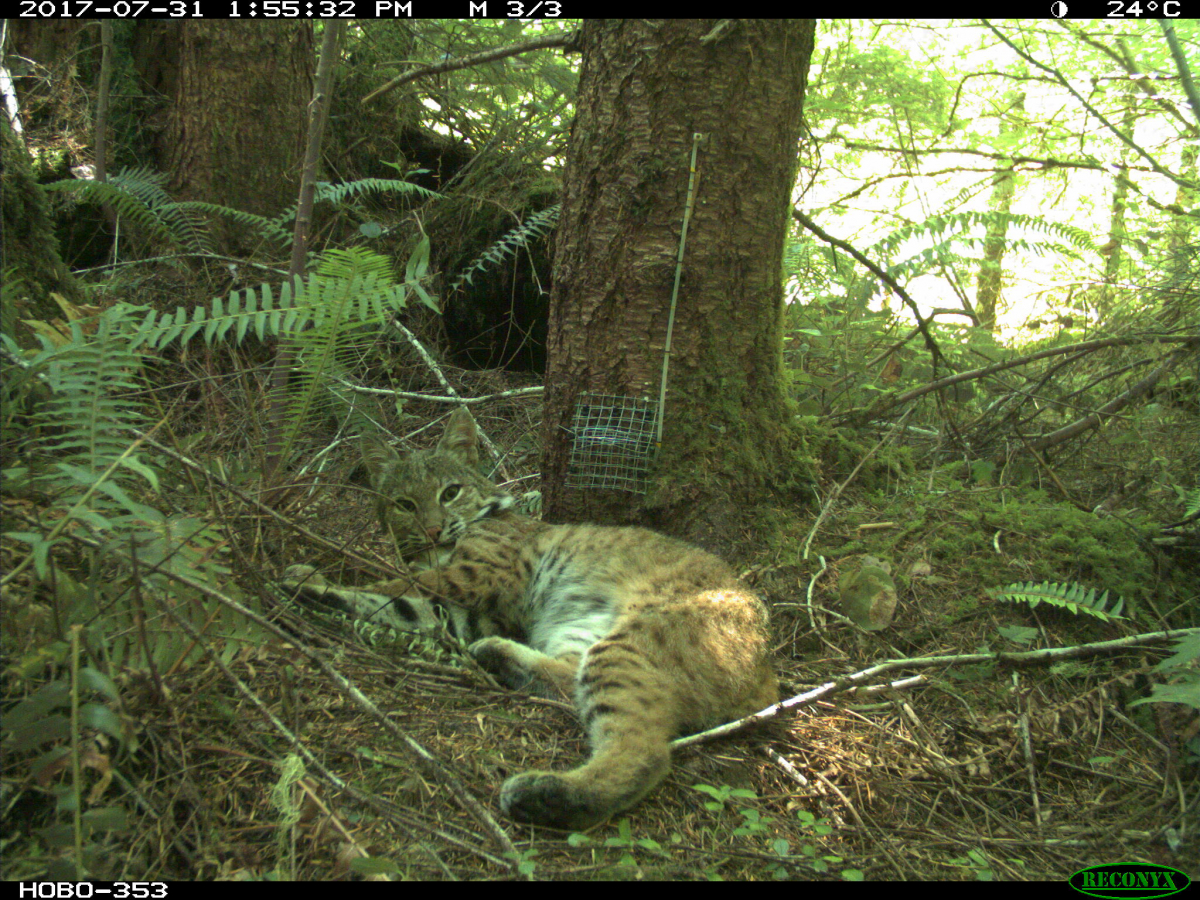
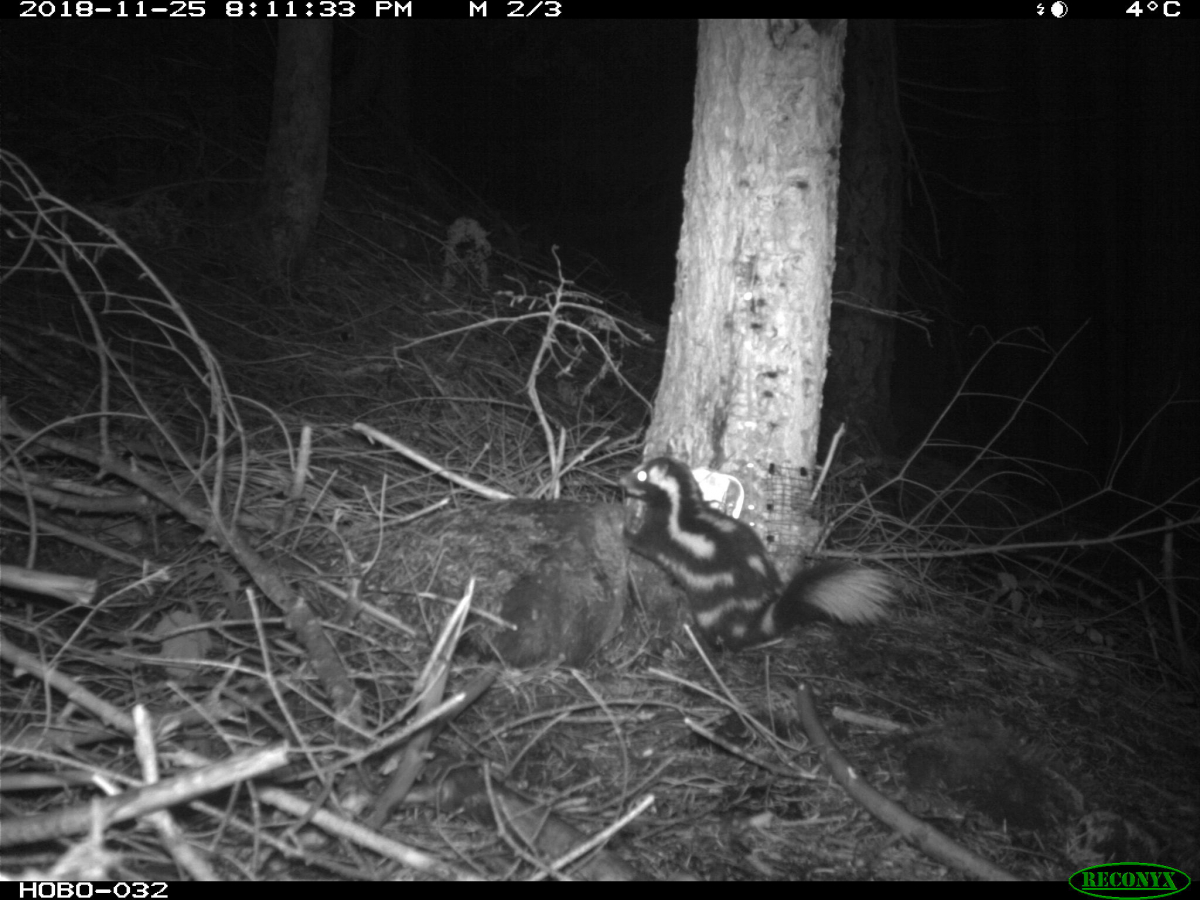
PhD student Marie Tosa set up her study on mammalian carnivores in the HJ Andrews Experimental Forest. Camera traps revealed wildlife including bobcat and, Marie's favorite, the Western Spotted Skunk.
September 13
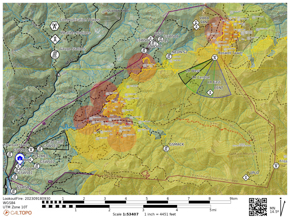
 Today's InciWeb update reports the Lookout Fire at 24,596 acres and 50% containment. Total Personnel: 699. Resources: 27 engines l 12 crews l 5 bulldozers l 24 water tenders l 6 masticators l 4 helicopters l 2 Skidders. Notes on operations within the Andrews Forest, on the north side of the fire are: "While no change in containment occurred on the Lookout Fire, firefighters and heavy equipment stayed focused on primary containment lines on the north side. Night operations hauled 36 loads of wood material from the fire’s northside and the White Pine contingency area east of Hwy. 126." As the heat map indicates, the fire picked up in activity as of late yesterday and we expect increased fire movement through the weekend given hotter, drier weather and winds. The fire is moving north into the area of McRae Creek and its tributaries. Graduate student Madelyn Maffia has been at the edge of her seat for weeks, watching online maps as the fire approaches the location of the drought experiment she has been working on for her graduate research.
A Look before the Lookout Fire. Post 20. A Drought Experiment
OSU Professors Dana Warren, Catalina Segura, and PhD student Madelyn Maffia are investigating the response of trout and salamanders to drought conditions in a tributary of McRae Creek. The researchers are using an experimental approach to mimic drought by (1) diverting stream flow to create a low-flow reach and (2) passively heating water through a coil system to increase water temperature. The experiment was disrupted by the Lookout Fire that is burning across McRae Creek and its tributaries. The loss is upsetting because of the time and effort that went into setting up the experiment, and because the findings would have had imminent relevance of understanding of how trout and salamanders respond to the drought during the hot and dry conditions often seen with wildfires.
Photos and more about the study are on our online photo albums for the 2021, 2022, and 2023 drought experiment field seasons.
September 12
 Today the Lookout Fire is reported at 24,548 acres and 50% containment. Total Personnel: 795. Resources: 35 engines l 14 crews l 4 bulldozers l 26 water tenders l 6 masticators l 5 helicopters l 2 Skidders.
Fire crews are monitoring the open line (where the fire is not contained) within the Andrews Forest. The Operations Section Chief for the fire operations reported today that the fire is “hung up on the north slopes” and only growing 6-12 inches (15-30 cm) a day. The location is “inaccessible to people getting in there and putting it out directly. The fire is backing down into the containment line, making a really good black line.” Crews also have contingency lines to the west as back up.
As of yesterday, the evacuation level at our headquarters facility was lifted to a Level 1 (“be ready”). Our full-time resident staff may move back into their apartments on site. The HJ Andrews Experimental Research Forest remains closed to the public and the research community, in accordance with Willamette National Forest Closures.
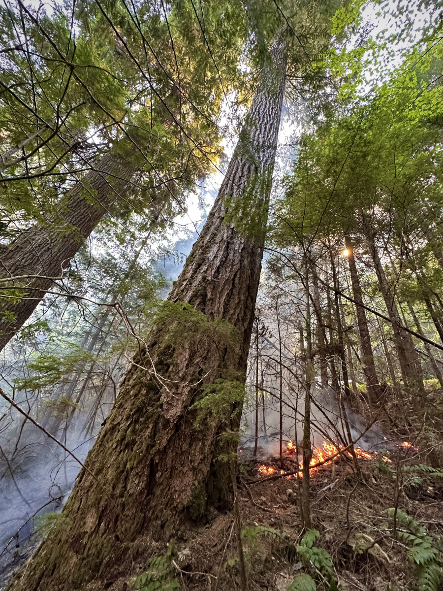
Fire suppression repair has begun. The Lookout Fire Information team shares the following: “What exactly do we mean by suppression repair? When wildland fires erupt firefighters respond quickly: bulldozers push-up gravel berms and reshape roads, hand crews build huge swaths of containment line, engine crews remove soil during mop-up, helicopters drop retardant, sawyers remove brush, and trees of all sizes. The effects across the forest can be long-lasting. If left unrepaired severe erosion, vegetation loss and harm to other forest resources may occur. The suppression repair objective is to repair damage caused by these fire suppression activities, and to return the affected area to pre-fire conditions as closely as possible. Their work is specifically designed to minimize surface and gully erosion, minimize sediment delivery to stream channels, restore conditions to pre-fire drainage patterns, minimize loss of soil productivity due to potential erosion in cleared areas, and minimize the introduction or spread of noxious weed infestations.”
For work within the research forest, we are in close communication with the fire operations crews to document the location of fire, fire lines, and fire suppression repair work, as they relate to, and directly impact, our research sites and infrastructure.
September 11
 Today's InciWeb reports the fire at 24,518 acres and 50% containment. The 50% of the Lookout Fire that is not contained is almost entirely within the HJ Andrews Experimental Forest; the area is remote with few roads, the terrain is "steep and deep", and the sheer size of the old-growth trees makes work harder for fire crews. Crews continue to work on a containment line along the 320 road, in an effort to keep the fire from spreading north. Today fire activity within the Andrews Forest is beginning to increase as the warmer weather dries the fuel loads.
A Look before the Lookout Fire. Post 19. Reflections and Fire
The Lookout Fire, as with the 2020 Holiday Farm Fire before it, triggers a rush of emotions and a deep sense of loss – maybe even a sense of guilt when we drop into thoughts of science opportunities when so much seems gone and never to “recover” in our lifetime. What will we find when we get to experience our favorite places in their newly burned state? How will the ecosystem respond over the coming few years? The on-going Following Fire: A Resilient Forest | An Uncertain Future project in the Holiday Farm Fire area of McKenzie River Trust land by photographer David Bayles and Fred Swanson gives some hints. The new 4-minute video and the Chronosequence photographs reveal the blackened forest and the emergence of life over the past few years. The chronosequence approach gives everyone a chance to find their own stories – both technical and emotional. David and Fred plan a similar project in the Lookout Fire area in sites of long-term research in collaboration with scientists and writers. This is all part of the Long-Term Ecological Reflections program that has been underway for over 20 years.
 Following Fire chronosequence photographs by David Paul Bayles
September 10
 Today's InciWeb reports the fire at 24,468 acres and 45% containment. "Containment grew by 10 percent yesterday as fire crews continue to mop-up and secure lines and reduce the fire’s footprint. Despite warming temperatures not seen since late August, there was generally low fire activity in all corners of the fire. Helicopters were ordered mid-day to douse hotspots along Carpenter Ridge. This slowed fire activity allowing hotshot crews and heavy equipment to continue connecting Forest Road 15 with the 1509." Within the Andrews, crews are finding success at using the 320 road as a containment line, closer to the fire and McRae Creek. Areas within the Andrews Forest continue to burn, showing up as hot spots on the heat map, as woody debris and large pieces of wood smolder and burn.
September 9
 Today's InciWeb report lists the fire at 24,457 acres and details fire crew activities specifically within the Andrews: "Completed contingency lines on Forest Roads 15 and 1509 will see debris removed as crews look to rehab those areas. Hand crews and equipment are looking for ways to connect their containment lines along Forest Road 320 to provide an additional contingency line along northwest side of the fire." This means that crews are working on fire containment closer to the fire on the north side, within the Andrews near McRae Creek. The 320 line could help reduce the fire spreading into the north corner of the research forest.
September 8
 Lookout Fire: 24,442 acres, 30% containment. Total Personnel: 784. Resources: 30 engines l 14 crews l 4 bulldozers l 28 water tenders l 7 masticators l 5 helicopters.
Fire activity was slow yesterday, as “Continued smoldering and creeping in heavy fuels and duff.” Crews are strengthening existing fire containment lines and making new lines closer to the fire, to restrict future spread. As the fire smolders and creeps – or “skunks around” in fire crew lingo – we watch the fire footprint from afar, from our computers, using online heat maps like CalTopo (see Aug 25 morning post for CalTopo key).
The Andrews Forest has been a place for study, for inquiry, for decades. It has been an USFS Experimental Forest since 1948, a Biosphere Reserve since 1976, a National Science Foundation (NSF) Long-Term Ecological Research site since 1980, a USGS hydrologic benchmark site since 1991, and an NSF National Ecological Observatory Network (NEON) site since 2017. Overlayed on these designations are decades of research from universities, agencies, and partners from across the nation and the world. Plus, the Andrews and its old growth forest hold a special, even sacred, place in the hearts of many who have visited. People are watching, and caring, from places far and wide.
A Look before the Lookout Fire. Post 18. Connections
Daniel McGarvey, an associate professor at Virginia Commonwealth University in Richmond, Virginia, contacted us early on in the fire to share his memories and connection to the Andrews Forest and Lookout Creek. “I traveled to Lookout Creek in 2018 to sample fish and stream invertebrates with a crew made up entirely of underrepresented minorities. This was part of my NSF CAREER project, which allowed me to take small teams of minority students all over the east and west coast.” The data collected in Lookout Creek were part of a larger study on how body size of fish and salamanders relate to their trophic position in the food web.
September 7
 Fire activity was noted on last night's heat map, as the fire smolders through tree snags and woody debris on the forest floor. Today's IncWeb reports the fire at 24,417 acres and 25% containment. Resources: 28 engines l 13 crews l 5 bulldozers l 29 water tenders l 4 masticators l 5 helicopters l 3 Skidder. Specifically within the Andrews: “Firefighters are strengthening lines and addressing hot pockets of activity on the western flank.”
A warming and drying period is expected to slowly dry fuels to a level where active spread is again possible. Our webcams give a bird’s-eye view of fog and smoke in the valley bottom with blue skies above.
A Look before the Lookout Fire. Post 17. On Birds
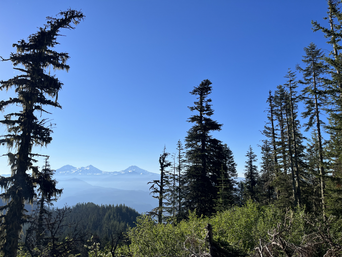
This is the time of year when migratory birds head south for the winter. Hermit Warblers fly two and a half thousand miles (4000 km) each fall, from their breeding grounds in the western Unities states to their wintering grounds in central America. In the spring, they’ll make the trip in reverse. When the warblers return to the Andrews Forest, graduate students Maddie Sutton and Nina Ferrari are waiting for them. Maddie, Nina, and their team record the abundance of over 80 bird species each spring across 184 locations, or points, as part of a long-term study on bird populations. That long-term study has already provided important insight into the importance of old-growth forests in providing thermal refugia for bird species that are sensitive to climate change effects. And the work continues. Maddie writes, “I have had the privilege to survey each of the bird monitoring points over the past four summers at the Andrews Forest to monitor bird presence throughout the forest. I've been fortunate to wake up with the birds singing every morning and to study how their abundance shifts across our 14-year dataset. One of my favorite spots to do point counts and conduct my dissertation research was on the top of Lookout Mountain (view from one of our points pictured below). There, we generally had our highest diversity of migratory warblers like Nashville Warbler, Hermit Warbler, and Yellow-rumped Warbler.” To date, the area of the Lookout Fire has touched almost 75% of all long-term bird monitoring points. To see images of Maddie at work, see https://andrewsforest.oregonstate.edu/gallery/bird-study-spring-2023 and https://andrewsforest.oregonstate.edu/gallery/bird-study-2022
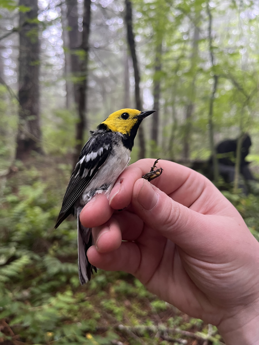
 A Hermit Warbler that was gently captured, measured and weighed, and released, as part of a long-term study on birds.
A view from the bird point count site on top of Lookout Mountain. Photo by Maddie Sutton, July 2023.
September 6
 Today's IncWeb reports that recent fire activity was low due to cooler temperatures and cloud coverage. The following activities are occuring within the HJ Andrews Experimental Forest: "On the northern side of the fire, crews will look to connect primary lines to existing road and trail networks. Mastication and log hauling will also continue to advance containment lines. Westside fire operations will continue with equipment and firefighters looking to merge primary and alternate lines. As conditions allow, aviation resources will support suppression efforts." New infrared flights provided more accurate mapping, showing a reduction in acreage; the fire area is reported now at 24,4040 acres. Changing conditions and perspective are the topic of today's reflection.
A Look before the Lookout Fire. Post 16. Light, Water, and Stream
With a digital camera and oil paints, artist Leah Wilson set out to document the change of light and color in Lookout Creek, Watershed 1, and Watershed 3 at the Andrews Forest. “My paintings isolate changes that are missed by human perception, even when staring directly at the landscape with eyes wide open.” In October 2014, Leah placed a rock painted white in a deep pool in Lookout Creek and photographed it every one minute, for three sessions. The white rock reflected the colors of the stream, the ambient light, and the surrounding environment. Back in her studio, Leah made digital translations of the colors and rendered them into oil paint, “a process that takes the image from a technological interpretation back to a perceptual human experience.” Leah painted the colors in a grid, where the top panels consist of the colors of the white rock affected by the water and ambient colors of the forest and sky, while the bottom panels are the colors collected from images of the creek bed at specific gridded points on the photograph. The colors in both panels are arranged by correlating time and rounds in squares of 16 distinct colors taken from each captured moment. You can see more of Leah’s work, called Ambient, at https://www.leahwilson.com/project/ambient. The original Ambient paintings are on display at the headquarters of the HJ Andrews Experimental Forest, normally. The paintings were carefully wrapped and put into storage in Corvallis when our headquarters were evacuated in August.
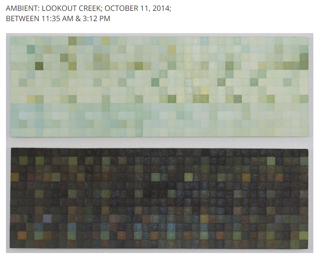 Ambient, by Leah Wilson. The top panel consists of the colors the water and ambient colors of the forest and sky, while the bottom panels are the colors of the bed of Lookout Creek.
September 5
 Today marks one month since the Lookout Fire ignited, by lightning, on August 5, 2023. As of today, the fire is reported at 24,581 acres and 20% containment. Resources: 33 engines l 15 crews l 7 bulldozers l 27 water tenders l 8 masticators l 5 helicopters l 1 Skidder. IncWeb: “Fire activity was minimal on Monday. Today, mastication along contingency lines, and hauling of logs will continue on the north side. Crews and equipment continue to prepare and improve primary and alternate lines along the west side, looking for opportunities to go more direct.” Areas of heat can be seen within the HJ Andrews Experimental Forest, where the fire continues to burn.
Given the recent cooler weather and the hard work of fire crews, evacuation levels have been lessened in the nearby McKenzie Bridge community. Access to our research site remains closed, and could be for months to come. The Lookout Fire has disrupted many of our ongoing, long-term studies, since researchers can’t access the site to collect data.
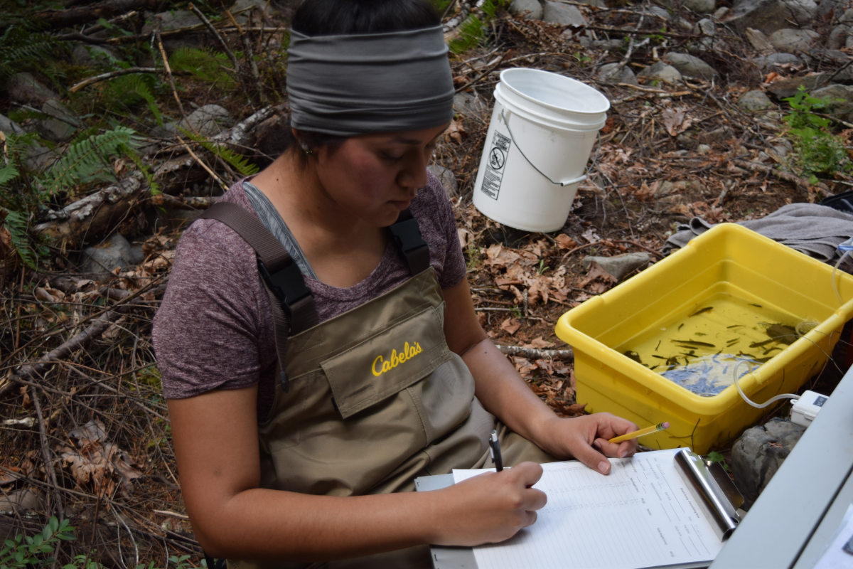
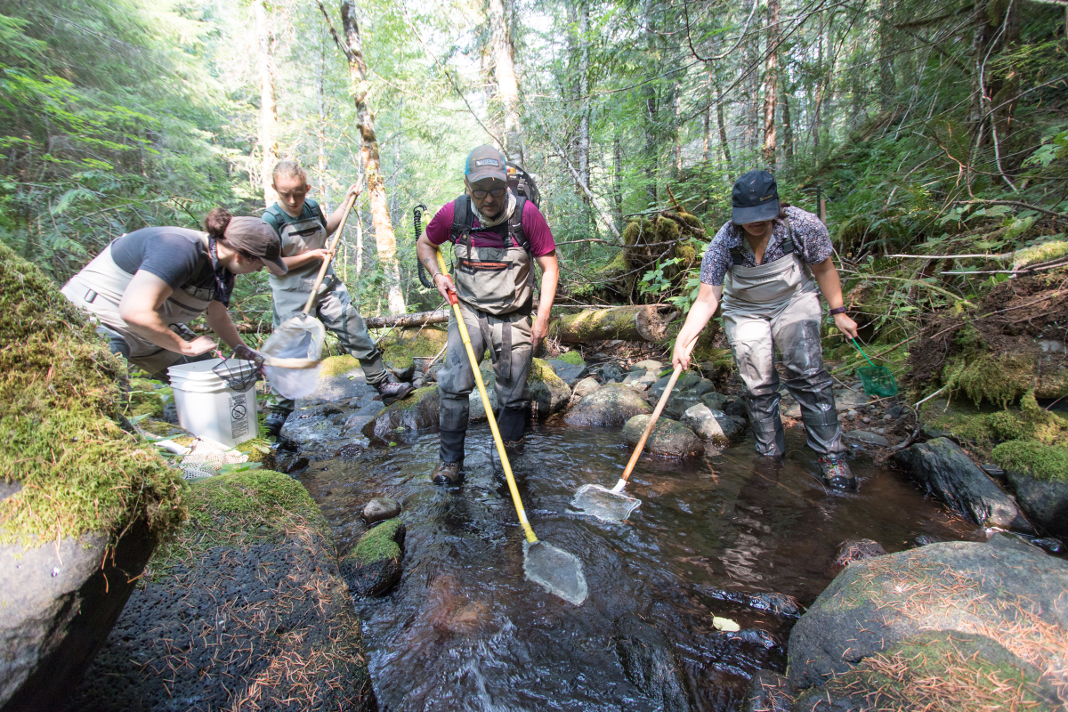
A Look before the Lookout Fire. Post 15. Long-term study of trout and salamanders
The first week of September typically marks the annual trip to Mack Creek for our team of researchers working on a long-term study of trout and salamanders. Since 1987, we have visited the same sections of Mack Creek to measure the numbers, size, and mass of these aquatic vertebrates. The study constitutes one of the longest continuous records of salmonid populations on record. The Lookout Fire burned over Mack Creek so we will not be able to go to the site to sample and collect data this year. The only other year that data were not collected in the 36-year study was in 2020, when access to the site was closed due to the Holiday Farm Fire. To see photos of the work, see the Aquatic Vertebrate Population Study in Mack Creek 2021 photo album.
September 4
 Continued cool weather has slowed the fire. InciWeb reports the fire at 24,581 acres and 20% containment. Total Personnel: 701. Resources: 32 engines l 14 crews l 7 bulldozers l 29 water tenders l 8 masticators l 6 helicopters l 1 Skidder. "The eastern side of the fire received light rain Sunday morning, resulting in minimal fire activity. Today, steep terrain on the western flank will be worked by Hot Shot crews to secure the fires edge. Crews will continue to prepare contingency lines, and work on hot spots throughout the fire area."
This Labor Day we extend our gratitude to fire crews and the fire operations staff who have been laboring, tirelessly, for weeks on the Lookout Fire. The official Lookout Fire 2023 Facebook page features several wonderful portraits of the people working the fire--see the FB posts from Sept 3 and Aug 31 specifically.
September 3
 Today the Lookout Fire is reported at 24,526 acres and 20% containment. The reported acreage for today is lower than yesterday, which probably reflects new mapping or more accurate IR flights with changing weather. From InciWeb: "Fire activity continued to be minimal on the Lookout Fire Saturday. The west side still holds significant heat and will be patrolled and monitored, with continued prep work on contingency lines. Tree fallers, fire crews, and heavy equipment will continue preparing fuel breaks along forest system roads to be used as primary and alternate control lines on the north side of the fire."
September 2
 Today the Lookout Fire is reported at 25,575 acres and 20% containment. Warmer temperatures and relatively high humidity are predicted for today. Forecasted rains from storms cells could result in ½” to 1” rain in places today. Drier weather is expected for tomorrow and the week ahead. The changing weather can be seen on our webcams -- this morning’s images show blue sky and high clouds over the smoky flank of Lookout Mountain. The seasonal shift, and the play of the seasons over the landscape, is part of today’s reflection.
A Look before the Lookout Fire. Post 14. Rivers as a storyteller of seasons and landscape processes
Jaime Ortega, an OSU graduate student who grew up in Panama, shares that one of his greatest memories at the Andrews Forest, specifically in the Upper Lookout Creek catchment, was admiring the fascinating changes in the forest throughout the four seasons and how rivers respond to storm events.
“As a foreigner coming from tropical latitudes, I have never had the opportunity to see how a landscape and rivers change throughout the seasons. During my water sampling campaign (May 2022- May 2023) as part of my research project, I was delighted by the colorful leaves of autumn, the fresh snow and quietness during the winter, and the high flow events as a result of snowmelt or intense rain. Each season has its own story and rivers are mirrors to understand how processes occur across the landscape. Through the use of water stable isotopes and stream chemistry, we hope to unveil the importance that geology and snow contribution from high elevations have in the streamflow contribution of some headwater streams (Cold, Longer, Nostoc Creeks) in the Upper Lookout Creek catchment.” You can find photos of Jaimie in the Lookout Creek Water Sampling 2022 album.
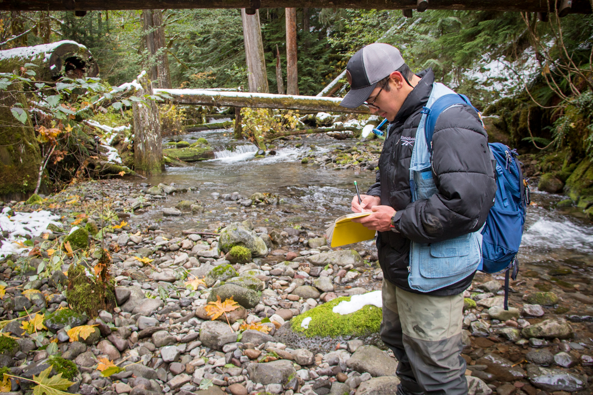
 Graduate student Jaimie Ortega records water samples in Lookout Creek. This photo, from November 2022, is from a stretch of Lookout Creek accessed from the Lookout Creek Old-Growth trail, now well within the burned area of the Lookout Fire.
A few of Lookout Ridge and Lookout Creek in February 2023.
September 1
 The fire is at 24,575 acres and now 20% contained. According to today's InciWeb report: "There was very limited fire behavior on the Lookout Fire due to rainy conditions, but large fuels (dead trees and logs) remain dry enough to carry fire. While precipitation moderates fire behavior, rain can create slippery road conditions and increase driving hazards for firefighters and equipment. Crews are also reporting that many fire-weakened trees have been falling near the fire lines." Also: "Mixed stands of varying age classes exist throughout the fire area. Old growth stands contain heavy surface fuel loading with an abundance of moss and lichen in the canopy. Younger managed stands have an understory of brush/shrub component. Primary carrier in old growth stands is 100- and 1000 hour fuels with spread accelerated by short range spotting from lichen. Primary carrier in managed stands is 10- and 100 hour fuels. The Lookout Fire is ceeping and smoldering in heavy fuels and duff. Any spread is limited to areas of very slow growth under heavy canopy cover."
Notably, yesterday we we received the first wetting rain since the fire began. While it's not enough rain to change the course of the fire, it has been helpful to the firefighting efforts.
A Look before the Lookout Fire. Post 13. Rain, Real Time
Rain, sweet rain! The rain gauge at our weather station near headquarters, PRIMET, recorded 0.69 inches of rain yesterday and last night, and there is a good chance of additional wetting rain on Saturday. Remarkably, our weather stations and communications towers remain intact, even those in areas that burned over in the fire. See our Post 6 on weather stations. We’ve been watching the weather data, real-time, as they stream from our weather stations, through our radio communications system, and are loaded to data graphs on our website. After quality checks, the data become part of our long-term climate record. With the recent shift in weather, this week’s data graphs show a drop in solar radiation, a jump in humidity, a decrease in wind speed and air temperature, and, at last, rain.
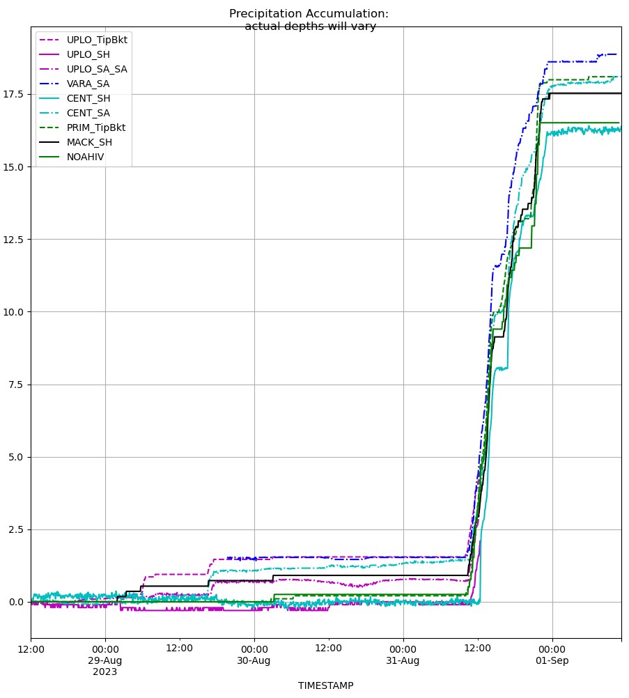
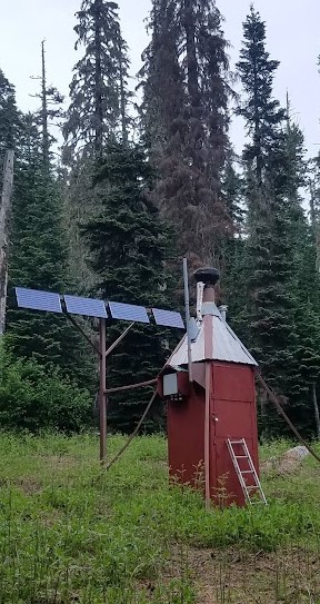 Our real time weather graphs show that yesterday and today we received about 0.69 inches of rain across our weather stations. The second photo shows a rain gauge on site -- it's the funnel on top of the red building.
August 31
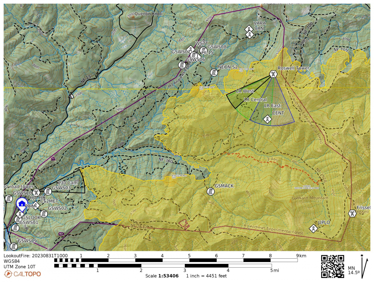 The InciWeb reports the fire at 24,340 acres and 17% containment. “To the northwest the fire is burning through the Andrews Experimental Forest in the McRae Creek and Deer Creek drainages with potential for slope reversal and uphill spread.” Fire crews are firing and prepping the 1506 and 1508 roads, to keep the fire from spreading west into our headquarters facility. To the north, fire lines are being prepared along Blue River, which is past the boundary of the research forest. We anticipate the fire to reach the north boundary of the HJA, unless conditions allow fire crews to bring in a closer line. Rainy and cool conditions are expected for much of the day, with rainfall totals of 0.30-0.70 expected by the morning of 9/1.
As the fire slows with today’s rain, we have a moment to reflect on our connections to the forest and the stories that bind us together as a community.
A Look before the Lookout Fire. Post 12. Long Term Ecological Reflections
Kari O’Connell, previously the HJA Forest Director and now the Associate Director at the OSU Center for Research on Lifelong STEM Learning, shares her reflection:
"One of my fondest memories of the Andrews Forest is the afternoon I hiked on the Watershed 2 trail with Howard Bruner and Robert Michael Pyle, during Robert’s residency (the first writers residency of the Long-Term Ecological Reflections program). In Robert Michael Pyle’s own words,
It rained most of the time, and we grew awfully wet and muddy, but stayed warm enough with exertion; and though we were slipping and sliding, balancing and hopping like a bunch of red tree voles, (or two, plus a small walrus), no one got hurt. My hardest hike in years, but truth to tell, I much enjoyed it. Frequently, we passed trees tagged long ago so their life trajectories and ultimate mortality could be measured; transect plots; and other signs of curious hands on this uncut basin. The responses of this forest, both to management and stochastic events (or, vicissitudes) will have been monitored over a long period, along with numerous other places involved in the LTER project.
The hike took us way longer than expected as we had to climb under and over enormous, downed trees and admire and appreciate plants and birds along the way. Robert Michael Pyle and his residency launched the Long-Term Ecological Reflections program, which brings together writers, humanists, and scientists to create a living, growing record of how we understand the forest and the relation of people to the forest, as that understanding and that forest both change over time."
Here are some links to some of Robert Michael Pyle’s writings: The Long Haul and Reflections: Field Notes (see II. Journal Entry for a description of this grand Watershed 2 adventure)
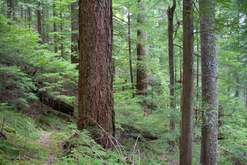
August 30
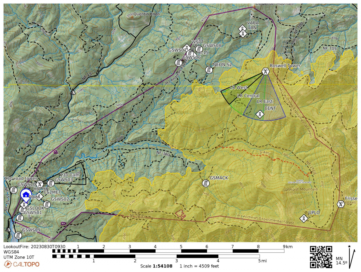 The official Lookout Fire 2023 Facebook page reports that "Due to an internet outage, we were unable to produce new maps for Lookout/Horse Creek/Pothole today. Little has changed from yesterday. Continued cooler temperatures and higher humidity for the past few days resulted in minimal or no fire growth. Firefighters and law enforcement officers maintain a presence in evacuated areas. Cool, moist onshore flow is expected to increase, with about 1/3 of an inch of rain predicted beginning Thursday night through Friday."
A Look before the Lookout Fire. Post 11. River Concepts and Mack Creek
Early in its run across the H.J Andrews Experimental Forest, the Lookout Fire burned into Mack Creek and it still continues to burn in that area. The old-growth section of Mack Creek is a place of special importance to everyone who has ever been there. It has been central to the International Biological Program, the River Continuum Concept, Long-Term Ecological Research (LTER), and many other major projects of discovery. Mack Creek is the site that launched our work on large wood in rivers in the mid-1970s, work that changed how we see and manage large wood in streams and rivers. Prior to the research in Mack Creek, the ecological and geomorphic roles of wood in stream ecosystems was largely unrecognized throughout the world. Below is a photo of Jim Sedell, inspirational force in stream ecology, pondering a big log jam, asking one of his favorite questions, "What's the story?" While the sense of loss is overwhelming for those who have studied and experienced this very special place, the deep ecological legacies and inherent resilience of the stream and its forest will shape its new trajectory.
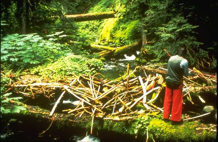
August 29
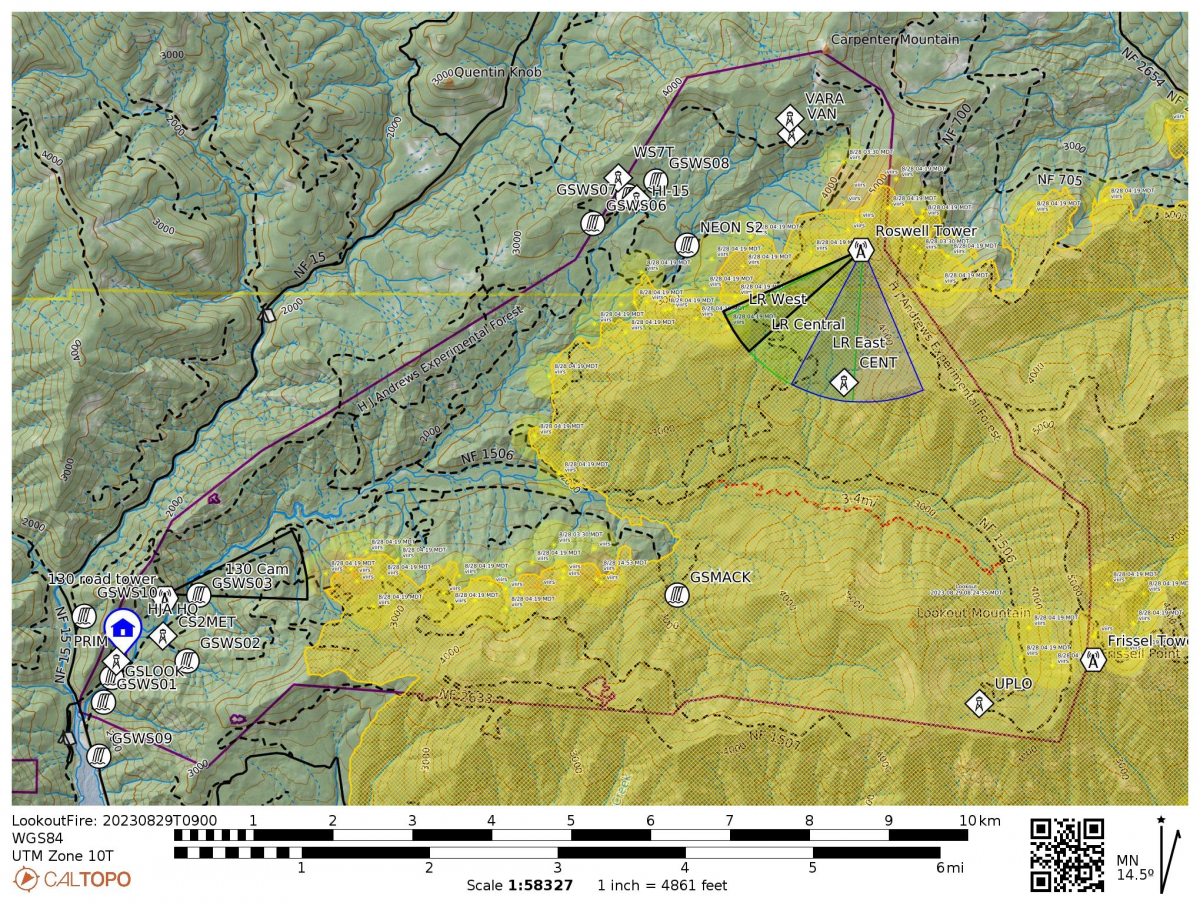 There was no infared flight last night due to weather so there are not updated numbers on fire acreage today. Cooler temperatures and higher humidity helped moderate fire behavior yesterday. Along the northern, western, and eastern flanks of the fire, fuel breaks are being prepared by tree fallers, fire crews, and heavy equipment along forest system roads that are being utilized as primary and alternate control lines to contain fire spread. Fire crews have been moved off the Lookout Fire to work on the nearby Horse Creek and Pothole fires. See more on the Lookout Fire 2023 Facebook page.
Specific to the Andrews, the fire has burned 3,676 hectares to date, which is 57% of the total 6,400 hectares of the site (a hectare is about 2.5 acres). See map below. Our webcams, still working, remarkably, show thick smoke and cloud cover. The fire severity—a measure of fire effects on the vegetation and soils and organic matter—has been changing almost daily based on weather conditions. We don't know yet how fire severity is playing out across the landscape and impacting the forest and the trees.
A Look before the Lookout Fire. Post 10. Trees and Ecotones
An ecotone is an area of transition between ecological communities. Todd Lookingbill, a professor of geography at the University of Richmond, has been studying the ecotone between western hemlock and true fir forests in Oregon’s Cascade mountains for more than 20 years. Since first mapping all trees in five large plots distributed from Lookout to Carpenter ridges within the HJ Andrews Experimental Forest in 2002, Todd and his student research teams have been returning regularly to remap tree seedlings and monitor vegetation dynamics. In 2013, they added ground-level temperature sensors and time lapse cameras to the plots to monitor snowpack. Todd’s research goal is to understand how environmental conditions such as temperature, snowpack duration and soil moisture relate to forest dynamics in these ecotones, which may be the most sensitive areas of the landscape to environmental change. The information feeds into a model that provides insight into potential forest response to environmental change such as global climate change scenarios. While the tree seedling composition in the old-growth plots that Todd is monitoring has so far remained relatively consistent over the past 20 years, fire imposes rapid changes in forest structure and environmental conditions, and may accelerate vegetation response to a changing climate. Four of the ecotone plots are within the burn perimeter and it is likely that all five will experience the Lookout Fire disturbance.
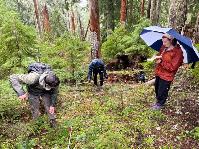 Todd Lookingbill and his students measure tree seedlings in a long-term study on ecotones. This photo, taken in 2022, shows a plot now within the area of the Lookout Fire.
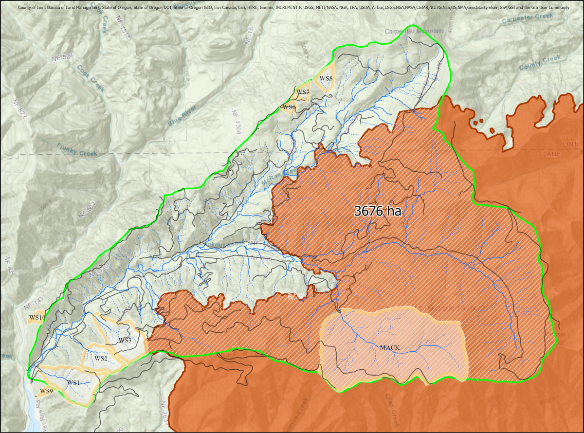 Map of the area of the H.J. Andrews Experimental Forest touched by the Lookout Fire, as of August 28, 2023. The fire has burned 3,676 hectares, or 57% of the total 6,400 hectares of the site (a hectare is about 2.5 acres).The boundary of the experimental forest is outlined in green. Rivers in blue. Roads in grey. Experimental watersheds are outlined in yellow. Click on the map for a larger view.
August 28
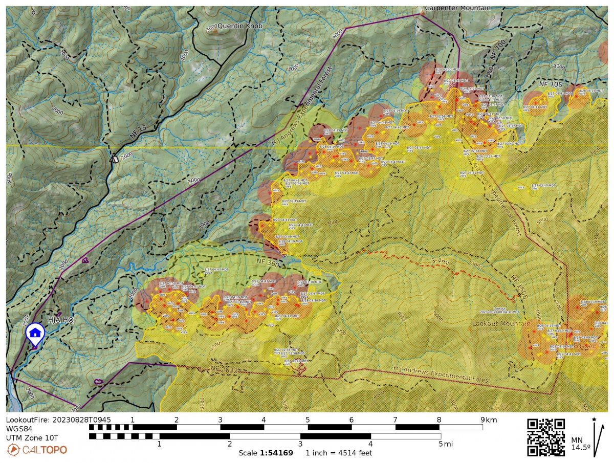 Today’s InciWeb reports the fire at 22,317 acres and 17% containment. Total personnel: 986. Resources: 55 engines l 16 crews l 15 bulldozers l 28 water tenders l 12 masticators l 9 helicopters.
“Cooler temperatures and higher humidity helped moderate fire behavior allowing firefighters to make good progress Sunday. Primary and alternate control lines are being prepared across the northern, western and eastern flanks of the fire to stop further growth beyond those lines. Helicopters were mostly grounded due to smoke but, as conditions allow, are being repositioned to better support ground resources. Forest system roads are being prepped by tree fallers, fire crews, and heavy equipment, as indirect containment lines.” For weather: “Winds from the west may be gusty along ridgetops and where topography aligns with winds. This condition often results in increased fire behavior where winds and drainages align.”
Two new fires started in the area on August 25, ignited by lightning. Fire crews are working to contain those fires, which are southeast of McKenzie Bridge. New and updated evacuation orders are in place. Our thoughts go out to the community members of McKenzie Bridge, including our site staff, who have been evacuated from their homes for more than two weeks. It will be some time longer before the area is deemed safe for their return.
Within the HJ Andrews Experimental Forest, the Lookout Fire is moving into the McRae Creek area.
A Look before the Lookout Fire. Post 9. McRae Creek NEON
McRae Creek, on the edge of the Lookout Fire this week, is home to an aquatic field site of the National Ecological Observatory Network (NEON). The continental-scale network collects long-term ecological data to understand how ecosystems are changing. The NEON study reach at McRae Creek includes a meteorological station and two in-stream sensor stations to characterize environmental conditions and water quality. Since 2017, NEON staff have collected water quality samples and monitor populations of fish, benthic microbes, macroinvertebrates, and more. In addition, NEON collects remote sensing data (LiDAR, hyperspectral imagery, and high-quality aerial photography) with periodic flights over the upper McRae Creek watershed. Check out NEON's website for more information or begin exploring NEON’s freely available McRae Creek data.
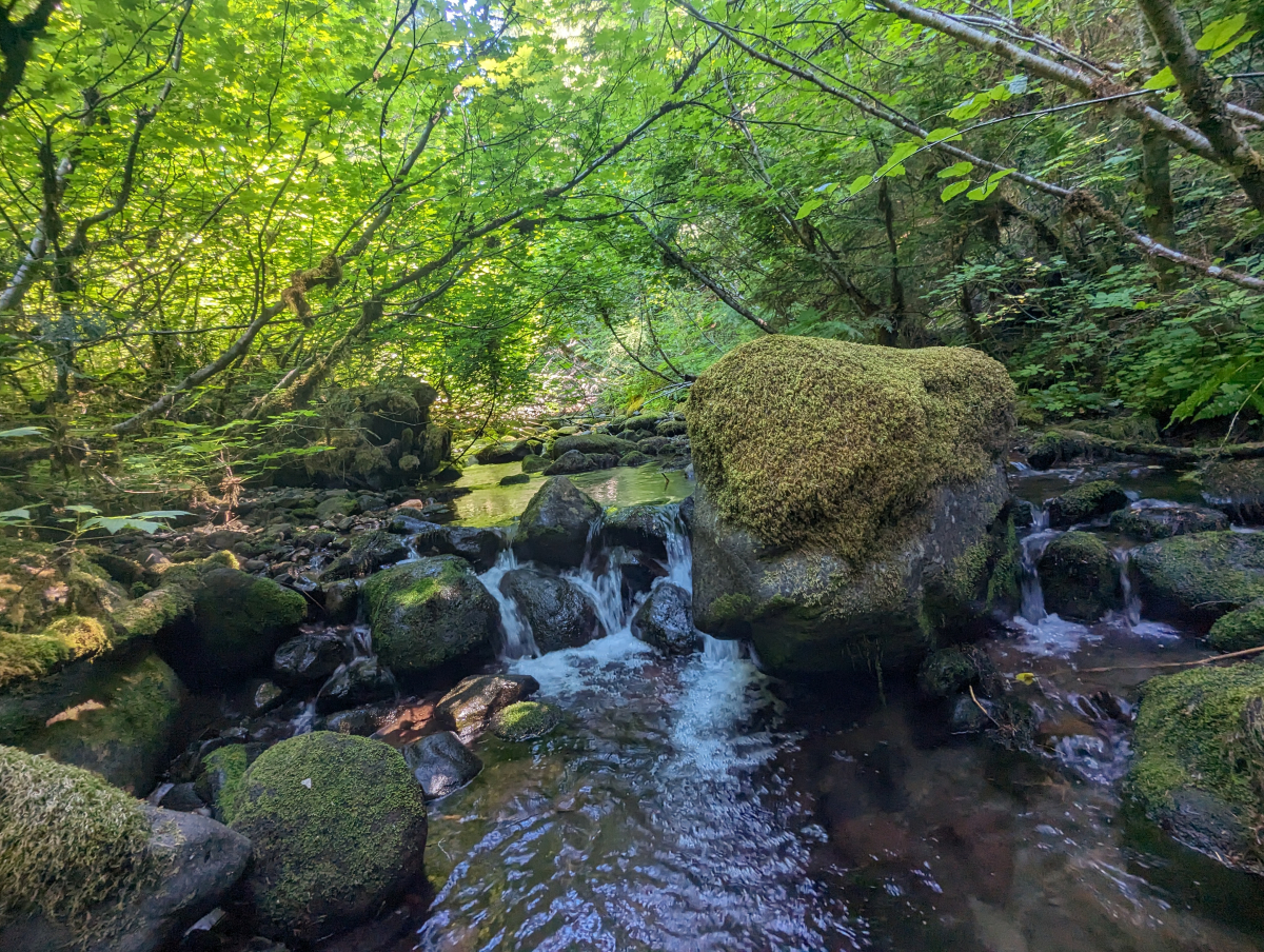
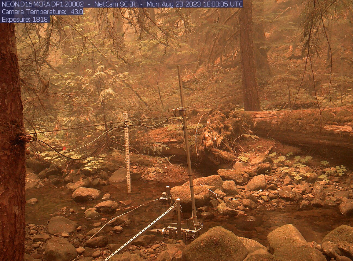
McRae Creek at the HJ Andrews Experimental Forest, and a stream-side phenocam image. orange with smoke, taken today, August 28, 2023.
August 27
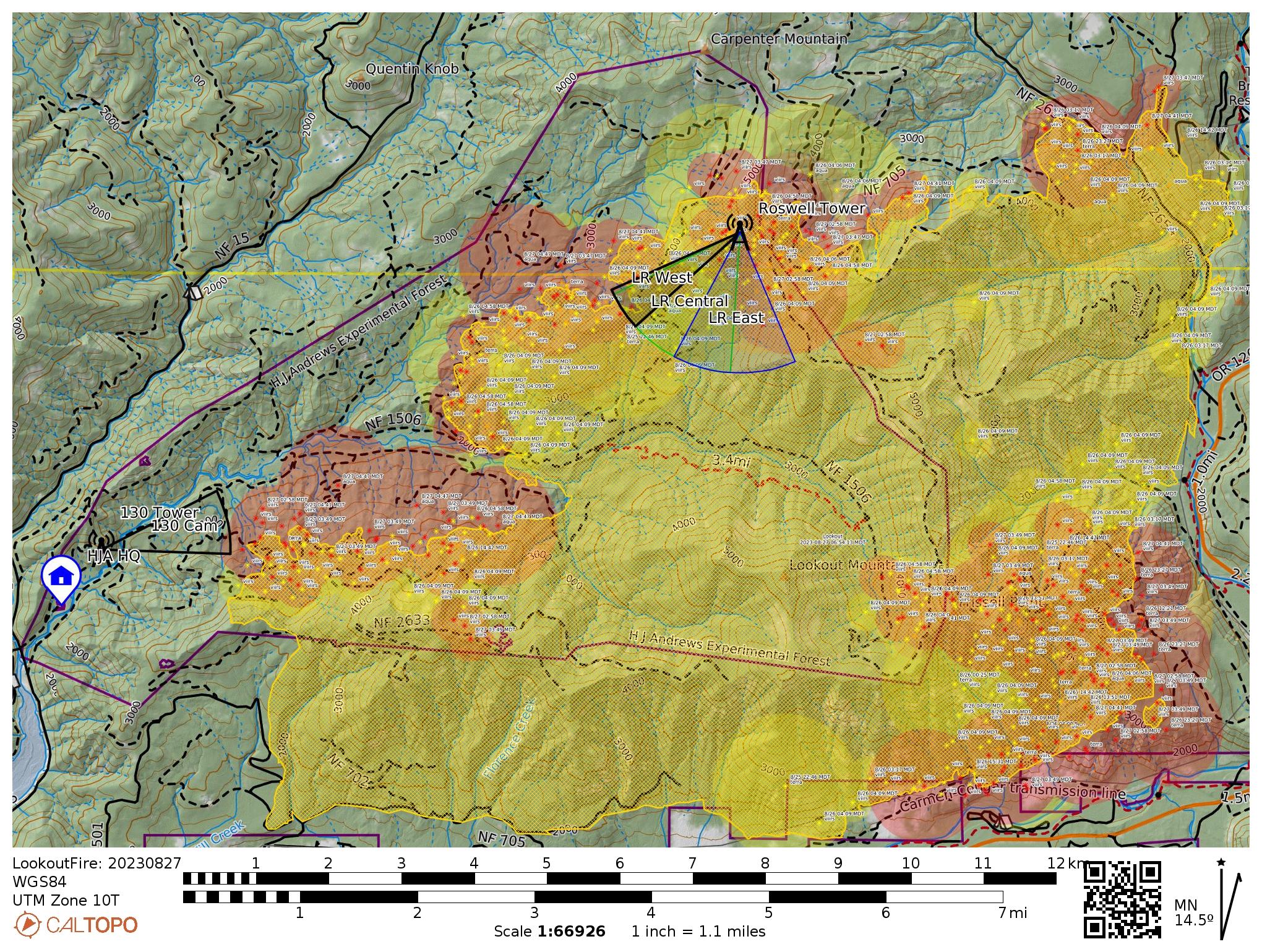 Today’s InciWeb reports the fire at 21,135 acres and 16% containment.
Quick Facts from the Lookout Fire 2023 Facebook page:
- Size: 21,135 acres
- Start Date: August 5, 2023
- Cause: Lightning
- Containment: 16%
- Point of origin: 3 miles North of McKenzie Bridge, OR
- Total personnel: 999
- Resources: 53 engines l 19 crews l 18 bulldozers l 30 water tenders l 11 masticators l 7 helicopters
August 26
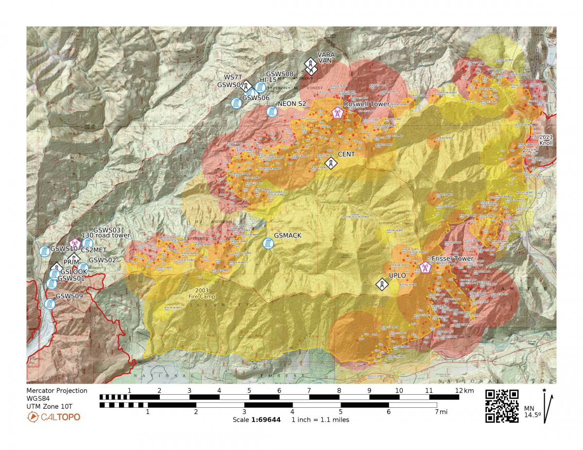 Today’s InciWeb reports the fire at 18,888 acres and 16% containment. Within the HJA: "On the southwestern flank moving north up Mill Creek Road, firefighters are steadily increasing containment as mop-up and strategic firing operations progress. Ahead of the northern flank, hand crews and engine crews, tree-fallers and heavy equipment are preparing roads to be used as control lines. Unmanned Aerial System (UAS) or drones are flying through the smoke to provide infrared heat imaging to locate additional threats to control lines. Drones are also supporting firing operations in areas that are hard to access, which reduces risk to firefighters."
With yesterday's strong and gusty winds the fire moved into McRae creek where we have many long term research sites. In advance, fire fighters protected our larger resources with a heat reflecting wrap, hoping for the best, but preparing for the worst. Here's a shout out to those hard-working fire crews and their huge efforts to protect structures across the McKenzie River community and the HJ Andrews Experimental Forest.
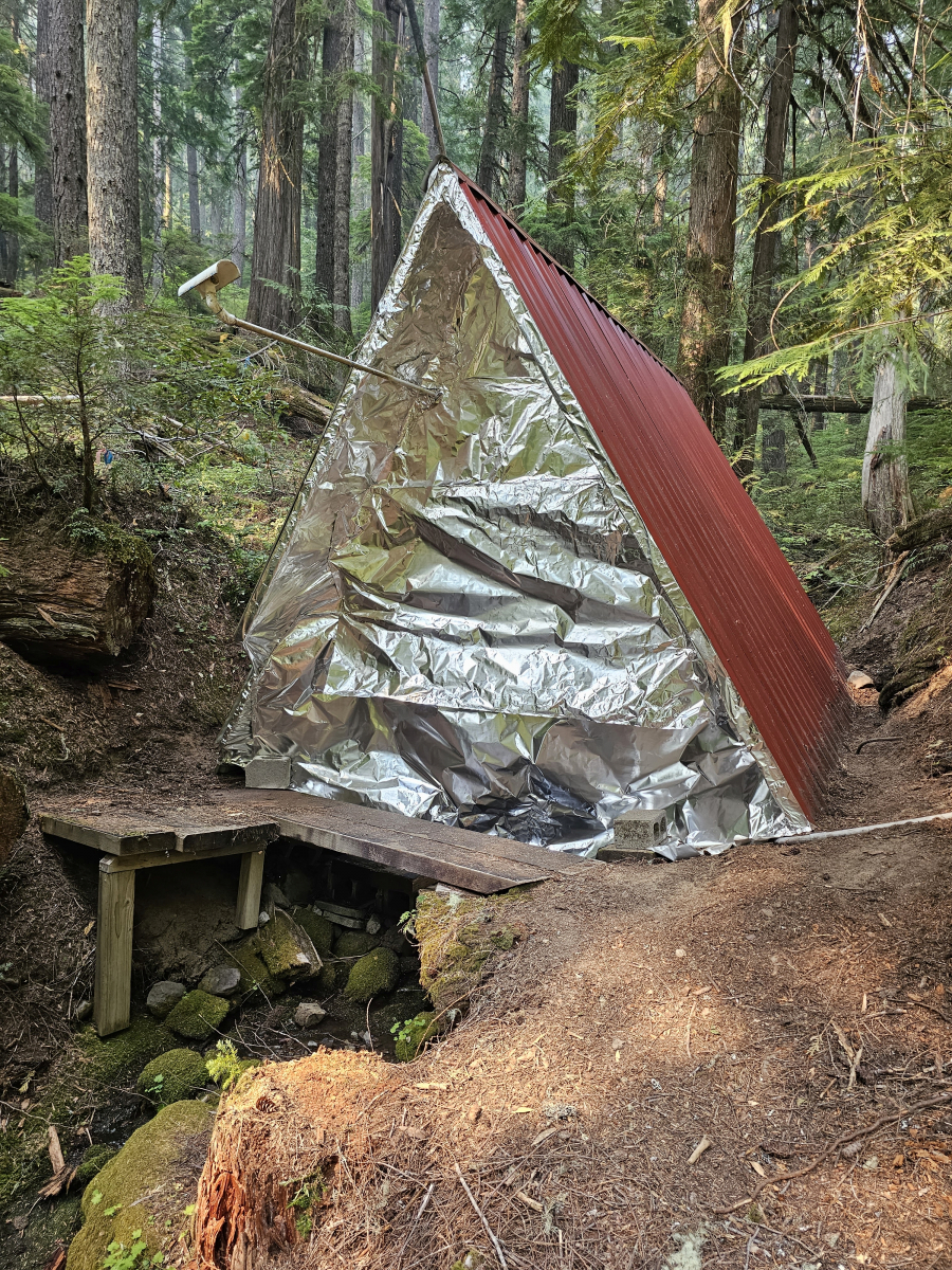
August 25, Evening
Things are moving quickly with the fire today, so we're posting twice. The CalTopo heat map shows fire over about two thirds of the experimental forest now. The fire moved up and over Roswell Ridge, then down into McRae Creek.
A Look before the Lookout Fire. Post 8. Webcams.
Roswell Ridge, which burned today, August 25, is a central hub within our wireless network and our webcam network. For years, we have maintained webcams to provide real-time information on conditions at the HJ Andrews Experimental Forest. Viewers can get a sense for current weather, road conditions, or the progression of the seasons. For example, our floodcam points at Lookout Creek and viewers can watch the water in the stream, and the wood in the stream, rise in the winter rains. The Lower Lookout riparian camera shows the changing of the seasons, as trees bud and leaf out in the spring, and drop leaves in the fall and winter. The headquarters camera shows activities at our research facility. This year, just after the Lookout Fire ignited, our site staff raced to the communications tower at the top of Roswell Ridge and trained three webcams on to Lookout Ridge, to track the fire and give an overlapping panoramic view of the south bounding ridgeline from Lookout Mountain to above the Headquarters site. The web cams have tracked the progression of the fire and smoke across the forest. As of today, August 25, the fire reached the forest west and south of the tower base (perhaps also north, but we are camera blind on that side). Should the tower succumb to the heat and fire, we will lose telemetry from almost all our weather and stream stations as well as the primary internet connection for the headquarters site. Check out our webcams online, especially the new timelapse videos of the Lookout Fire, linked at the top of the webcams page. Today's 8/25 Lookout Ridge Central timelapse video captures the fire coming up and over Roswell Ridge: fireworks of bright flames approaching in the dark of night, a yellow sunrise over green trees, an intensely smoky period with wind and airborne detritus, orange flames licking at the camera, and, lastly, defoliated trees standing in thick smoke. Another cam to keep an eye on: the Road 130 cam is on the ridge just above headquarters and faces Roswell Lookout ridges; it is generally too smoky too see far but this camera has given glimpses of the fire front as it crossed over Roswell Ridge, and will have a front-row view should the fire progress to the lower portions of the Lookout Creek basin.
The map below shows this afternoon's heat map with added icons for the 130 tower and webcam, bottom left, and Roswell tower, on Roswell Ridge, top right, with projected cones of view for each of the webcams. We have yet to see if the Roswell tower and its electronic components will survive the fire beyond today.
August 25, Morning
Today’s InciWeb reports the fire at 15,924 acres and 16% containment. The containment is along the SW edge of the fire, just north of HWY 126. Total personnel: 1,066. Resources: 48 engines l 21 crews l 17 bulldozers l 26 water tenders l 11 masticators l 7 helicopters.
“Gusty winds and hot, dry weather across the region resulted in increased fire behavior on the Lookout Fire on Thursday. Thunderstorms occurred over the area with lightning and no significant rainfall was recorded over the fire area. Friday’s forecast calls for similar conditions with a chance of thunderstorms. Lightning started a new fire last night near Horse Creek, south of Highway 126. Crews from the Lookout Fire and local resources mobilized to find and contain the four-acre fire. Detection flights will take place this morning to search for new starts in the area of the Lookout Fire.”
Fire crew activity specifically within the HJA: “Ahead of the fire’s northern flanks, crews, tree-fallers and heavy equipment are preparing roads to be used as control lines.” Today the crews may have better weather for controlled firing on the containment line. They are prepping and making plans for containment lines off the 1508 and 1506 road, cutting through the ridges to get a containment line closer to the fire.
Map colors and lines?
We’ve been using CalTopo maps to track the activity of the fire over the landscape. What do the colors and dots and lines mean on these maps? Here’s some helpful information, from the Caltopo Fire Layers Information Guide: CalTopo provides satellite imagery of heat detections, or “hot spots.” The infrared data from multiple satellite platforms contribute to hotspot detection, from which we can infer fire activity. The time and date of each hot spot along with the satellite that the data came from is shown on the map. Each hotspot also has an error radius around the point based upon error reporting from the satellites. Finally each hotspot is color coded based on the time of the report. Red dots are most recent (less than 12 hours), then orange (12-24 hours), and finally yellow (24-48 hours). After 48 hours the hotspots are removed from the map. Additionally, CalTopo displays the active fire perimeter from the National Interagency Fire Center on all the satellite views. These perimeters typically are updated once daily and come directly from incident management teams at the scene of the fire. They are based on a combination of reports from fire crews, satellite information and fire aircraft doing infrared flights or firefighting.
At our end, we’ve added a symbol to the map to show you the location of our headquarters facilities, in the SW area of the experimental forest.
August 24
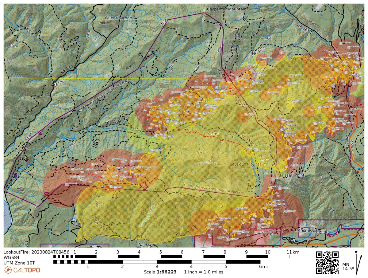 Today’s InciWeb reports the fire at 14,286 acres and 6% containment. Total personnel: 1,118. Resources: 59 engines l 21 crews l 14 bulldozers l 29 water tenders l 11 masticators l 6 helicopters.
"Fire behavior was active on the Lookout Fire on Wednesday. Warmer, drier conditions fostered successful burning operations on the fire’s west and east flanks. Aided by helicopters and a UAS (Unmanned Aerial System) or drone, crews progressed with firing operations designed to strengthen control lines along Mill Creek Road." Helicopters have been dropping spheres of fire retardant around the fire perimeter, "to pull fire off the line." Within the HJA, crews moved from the 106 road east to the 465 road and are looking to tie the line into the 1506 road. The fire continues to grow within the HJA and is backburning, which means that its being pushed by winds into previously burned areas.
A Look before the Lookout Fire. Post 7. Long-Term Vegetation Plots
Studying forest dynamics takes decades, even centuries. The western Cascade Mountains of Oregon, including the H. J. Andrews Experimental Forest, harbor centuries-old stands of old-growth forests, which are known for their high biomass, complex structure, and multi-layered forest canopies. In 1971, scientists established multiple permanent sample plots across the H. J. Andrews Experimental Forest and elsewhere in the region, largely to study old-growth forest ecosystems. Scientists continue to visit the plots every year. For every tree in each plot, researchers measure health, growth, and mortality. Over the years, we have learned about how forests develop into complex, old-growth forests, the processes that maintain that complexity, the importance of that complexity for how these forests function, and what might happen to these forests in the future. As of the time of this post, August 24, twelve of the permanent sample plots have burned in the Lookout fire.
To learn more about this long-term research, visit the story map, Plotting the Future by Monitoring the Past. You can find photos of the field work and the forests in our 2018 photo album and our 2021 photo album, and photos from a resurvey after the 2020 wildfire.
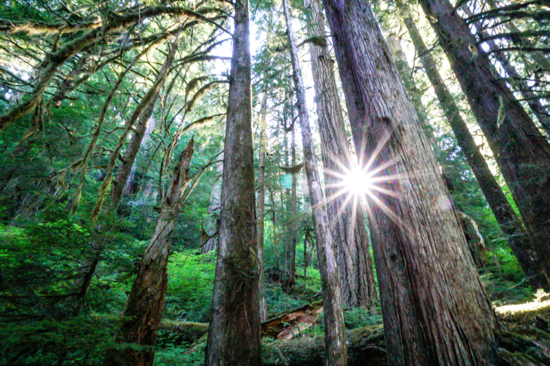
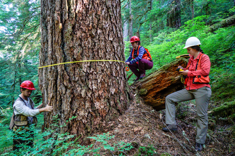
August 23
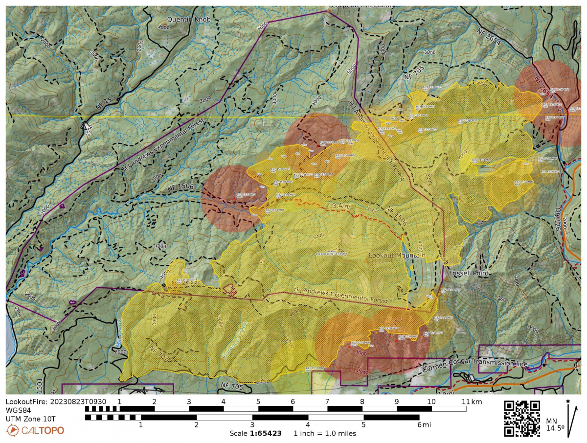 Today’s InciWeb reports the fire at 12,368 acres and 6% containment. Total personnel: 1,213. Resources: 72 engines l 23 crews l 14 bulldozers l 31 water tenders l 11 masticators l 6 helicopters.
“Fire behavior was moderate at the Lookout Fire on Tuesday, with the exception of several spot fires across Deer Creek Road on the fire’s northeast flank. Hand crews and engine crews are making good progress containing the spot fires, assisted by water dropping helicopters. Gusty winds out of the west cleared out dense smoke lingering over the area yesterday, giving way to clear skies and improved visibility for air operations. A warming trend will begin today, with critical fire weather and a chance of thunderstorms forecast for Thursday. In the higher elevations along the northwest flank, yesterday’s cooler temperatures and higher humidity inhibited burning operations intended to secure road 2633 (Mill Creek Road). Firing operations will progress in this area today, and along the fire’s southeast flank, in more favorable burning conditions. Above the fire’s northern flank, crews with heavy equipment including bulldozers and masticators are clearing hazard trees and vegetation along roads, preparing for burning operations to prevent the fire’s spread to the north. On the fire’s southern flank, firefighters are progressing with mop-up along the 700 Road, working to the east.”
The fire map showed moderate fire activity within the HJA . The fire moved over the CENMET weather station yesterday and today is moving up Roswell Ridge. Fire crews are working on the 1507 road to use as a containment line, and tie that into the 1506 road (west end of HJA). Crews are working in the area 24 hours a day.
Yesterday, August 21, Senator Ron Wyden, Congresswomen Val Hoyle, and Lane County Commissioner Heather Buch came to the Interagency Office in Springfield, Oregon. The Incident Commanders for the Lookout, Bedrock and Salmon Fires gave an overview of the initial attack and suppression efforts for each fire.
August 22
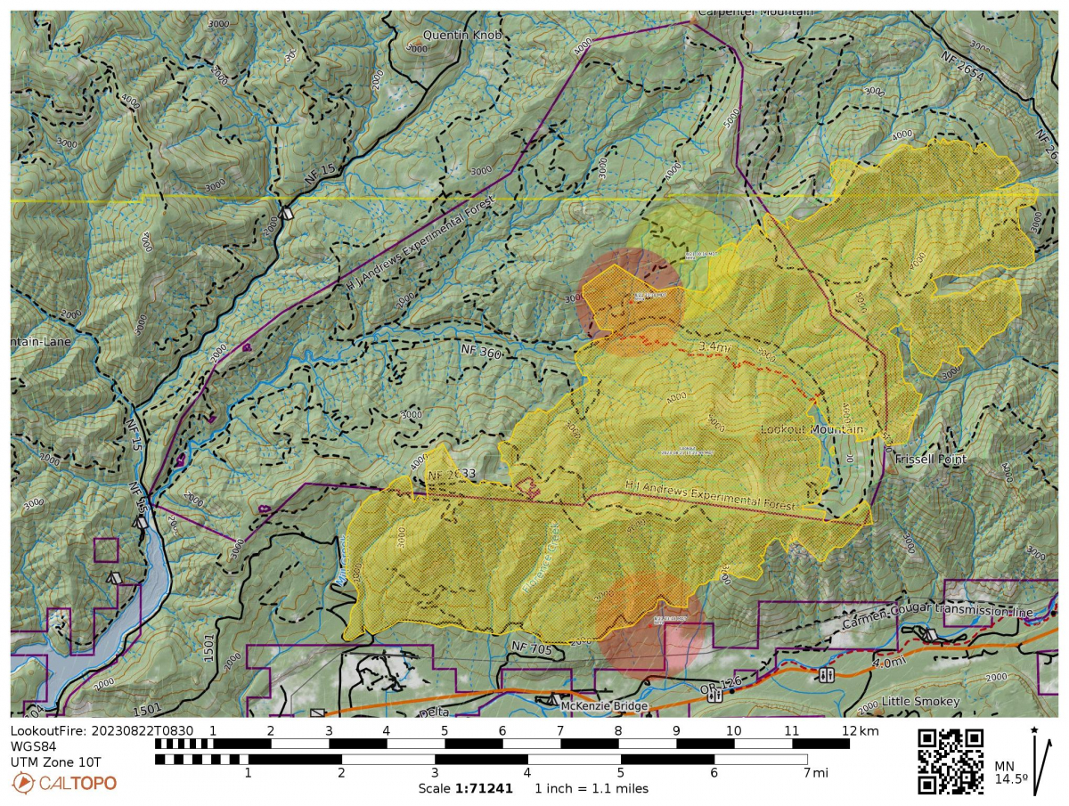 Today's InciWeb lists the fire 12,188 acres. Containment is 5%. Total personnel: 1,130. Resources: 73 engines l 21 crews l 13 bulldozers l 28 water tenders l 11 masticators l 7 helicopters. "Cooler temperatures and higher humidity limited fire behavior at the Lookout Fire on Monday. Dense smoke stayed in place over the area until late in the day, grounding helicopter operations. Firefighters mopped-up ash-pits and hot spots along the 700 road on the fire’s southwest flank, and containment is expected to increase in this area in the coming days. North of the 700 Road, bulldozer lines are in place to help utilize Road 2633 as a holding feature on the fire’s west flank. Cooler weather limited the effectiveness of tactical firing operations planned on the western side of the fire yesterday. Firefighters are prepared to conduct those strategic burning operations as conditions allow." "Winds from the west may increase Tuesday afternoon as the smoke inversion layer begins to lift. A warmer weather trend is expected to return to the fire area on Wednesday."
The official Lookout Fire 2023 operational update shares a video and explanation of the work being done to protect the headquarters facility. A HUGE thanks to the crews for their hard work in setting up sprinklers and protecting structures.
August 21
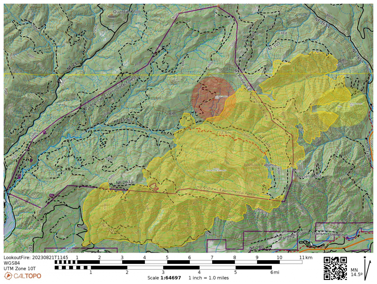 Today’s InciWeb reports the fire at 11,174 acres. Containment is 5%. Total personnel: 1,061. Resources: 65 engines l 19 crews l 13 bulldozers l 27 water tenders l 11 masticators l 7 helicopters.
This fire is on remote, rugged, steep terrain, and fire crews have been working tirelessly to protect the community and minimize the acreage burned. The official Lookout Fire 2023 Facebook page shares photos and details of activities across the entire fire perimeter. Specifically, within the research forest: “Hand crews, fire engine crews, tree-falling modules, masticators, feller-bunchers and bulldozers are clearing hazard trees and vegetation along Road 2633 and working to the north. Burning operations to secure these roads will take several days to complete.”
Our webcams, pointed toward the fire area, show the region thick with smoke. That thick smoke may have moderated fire activity yesterday. The official fire report says, “Fire activity was moderate on the Lookout Fire yesterday, with heavy smoke and light winds persisting into the evening. Cooler temperatures, higher humidity, and a slight chance of light rain is forecast for Monday and Tuesday before a warming trend returns on Wednesday.”
A Look before the Lookout Fire. Post 6. Weather Stations
For the past few days, the Lookout Fire has been burning around one of our remote weather stations, Upper Lookout (UPLMET), and is nearing a second, Central (CENMET). Fortunately, as of the time of this post (August 21), the UPLMET station continues to send useful weather data over our network of radio relays. The first weather stations at HJA were installed to aid research on logging methods starting in 1952. Three more stations were added over time. Today we maintain seven weather stations spread out to capture the environment across the entire research forest. Measurements include, precipitation, temperature, humidity, wind direction and wind speed, solar radiation, and snow. In addition to capturing variation and changes in climate over the years, the weather data are used as reference for many of the other studies that happen on the forest. For example, how does climate relate to vegetation types and changes in vegetation cover over time? Or how does weather measured, such as precipitation, snow, and soil moisture, relate to stream flow, or disturbances such as flood, landslides, and, yes, fire? Like all of the data we collect, the weather data are made public on our website and in a national data repository. In addition, this month, our field technicians, Greg Cohn and Adam Kennedy, put together a new Lookout Fire Wx web page, in direct response to the needs of fire crews working on the Lookout Fire. These weather measurements are providing fire crews helpful information to strategize and stay safe while trying to contain the Lookout Fire. We want to extend our thanks to fire crews who cleared nearby vegetation and set up sprinklers around the weather stations to protect them from the fire.
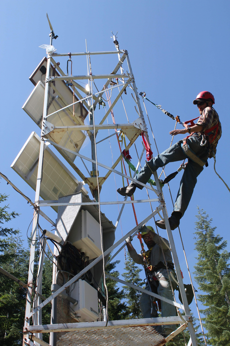
August 20
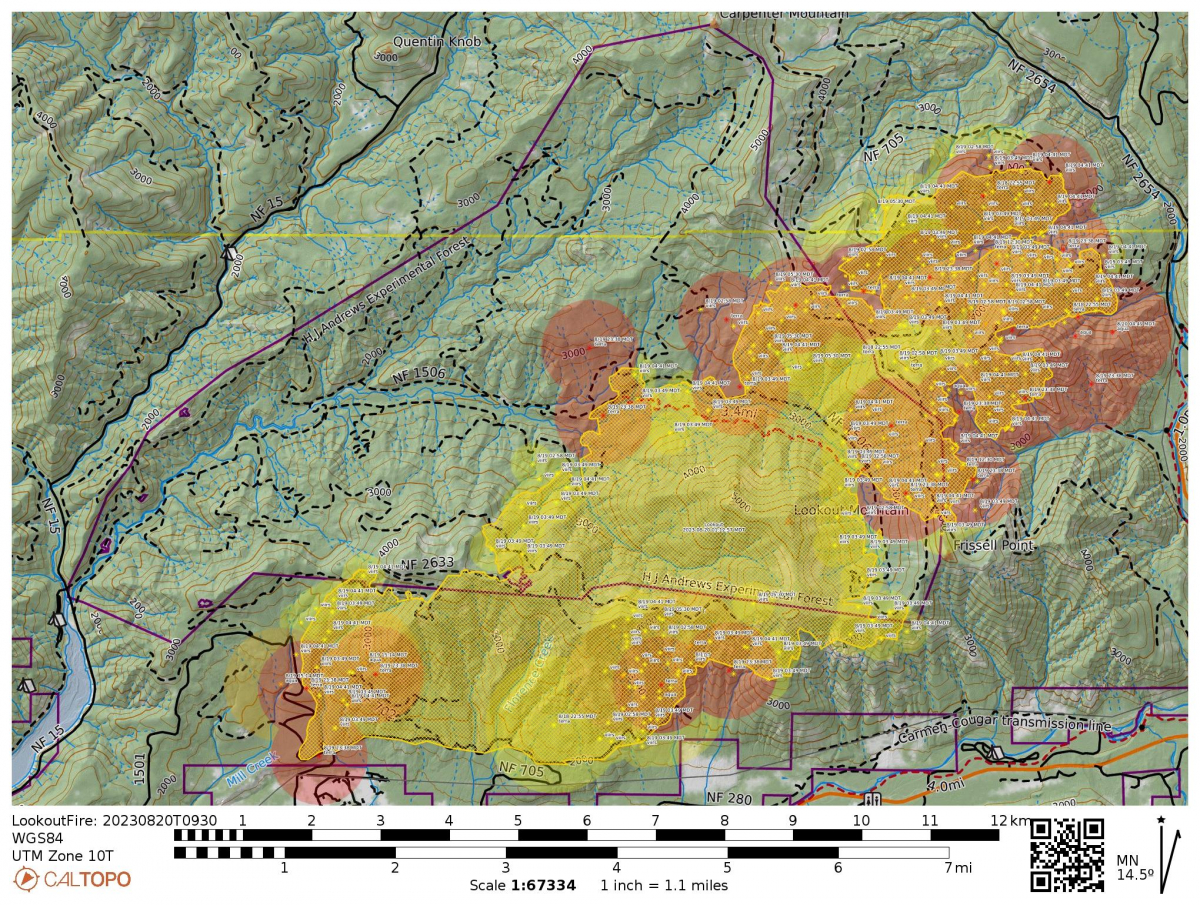 Today's InciWeb reports the fire at 10,521 acres. "Fire to the east across Frissell Ridge into Budworm Creek is backing down to within 3/4 mile of Deer Creek. The south, west and north portions of the fire experienced continued back and flanking towards the wprimary lines. Smoke cap over the fire area kept fire behavior moderated through most of the day." Today, within the HJA boundary, "Crews will continue to strengthen the 1506 road and look for options to improve the 360 road to decrease the fire footprint. From the 360 road, crews have completed handline near drop point 12 tying back into the 1506 road. Crews are planning to use tactical firing operations along the 350 road to keep fires edge in check." And, "Resources have completed the structure protection prep and plan for HJ Andrews Experimental Forest HQ."
A Look Before the Lookout Fire. Post 5. Carpenter Mountain Fire Lookout
Rob Mutch, the USFS Fire Lookout stationed on Carpenter Mountain, was on duty on August 5 and was the first to spot the tell-tale waft of smoke from the flank of Lookout Mountain, following the lightning storm on August 5. Rob, who is also a professional photographer, shared photos of the fire a week later, as conditions caused a massive column of smoke. For safety, Rob was moved from his station on Carpenter Mountain and is now assisting other USFS fire lookouts in the area. Rob has served for several summers as the official Fire Lookout on Carpenter Mountain and his trained eye has been invaluable in watching over the region. Thank you, Rob! Rob Mutch's facebook page shows photos of the progression of the fire, from his vantage point on Carpenter Mountain.
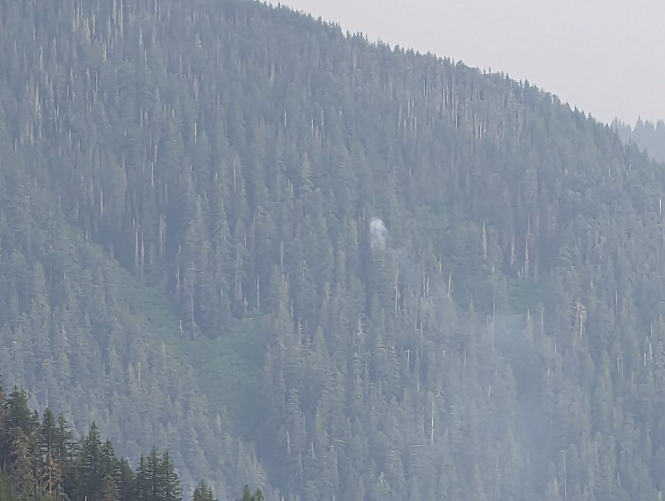
August 19
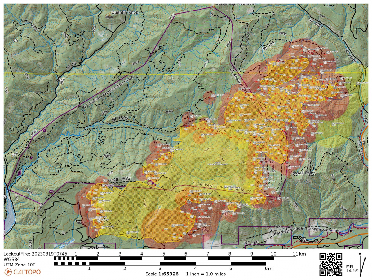 The fire grew significantly last night and is expected to be active today as the region shifts into red flag warning conditions -- hot and dry and windy. InciWeb reports: "The most active part of the fire will be in the north and north east today. Internal burning is occurring where there are pockets of unburned vegetation within the fire perimeter." "Today’s activities: Crews will be ensuring lines hold with the weather shift. Firefighters are continuing preparation on the 2633 Road in the west to use as a control line. Where conditions allow, firefighters will use strategic firing operations to strengthen fire lines. Firefighters are working on the 1508 Road using heavy machinery to remove vegetation which helps prevent fire spread. A mobile retardant base has been set up near Tokatee Golf Course. Retardant drops will be used in key areas to assist crews on the ground in slowing fire activity while they work." Evacuations and closures in the area have expanded, including part of HW 126. See the official Lookout Fire 2023 Facebook page for full information on closures and evacuations and a recording of today's operational update.
Size: 8,609 acres
Total personnel: 907
Resources: 46 engines l 19 crews l 10 bulldozers l 16 water tenders l 4 masticators l 7 helicopters
The official Lookout Fire 2023 Facebook page includes photos from Lookout Creek and an explanation of the laborious work of laying fire containment lines. Photos are courtesy of Ben Nash, who works as a hydrologist on the HJ Andrew Experimental Forest with the USFS PNW Research Station and is serving as a temporary resource advisor to the fire crews.
August 18
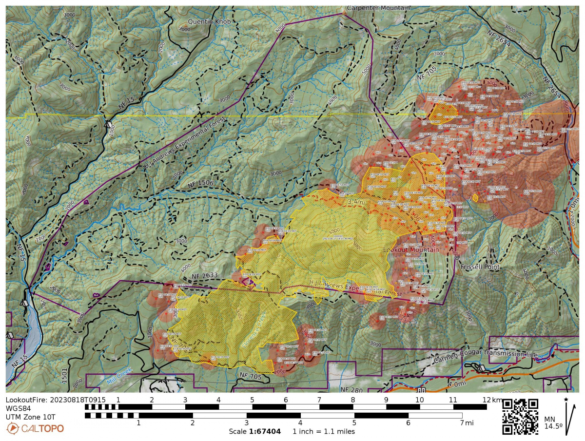 The fire is growing to the NE and now stands at 5,537 acres. Today's InciWeb reports, "The fire continues to stay north of Forest Road 700. The successful work from firefighters conducting strategic firing operations is protecting the community of Mckenzie Bridge, including Taylor Road and North Bank. The fire continues to be most active in the northeast where a spot fire burned and spread across the 1506 road in Budworm Creek. To date no structures have burned because of the Lookout Fire. In the northeast crews have started preparing Deer Creek Road to use as a control line. Firefighters will continue to hold the fire north of the 700 Road by extinguishing hot spots. In the west and northwest, line is being built and secured by digging handline and using heavy machinery to connect primary control lines. Crews are connecting the 2633 Road to the 725 Spur Road to prevent fire spread to the west. Strategic firing operations maybe utilized in the east if conditions allow."
A Look Before the Lookout Fire. Post 4. Cold Creek.
Today, within the HJ Andrews Experimental Forest, the fire is burning over Cold Creek. Here’s something interesting about Cold Creek: Cold Creek has more water in the summer than would be estimated for the size of its watershed. In fact, water from Cold Creek flows into Lookout Creek and makes up about 80% of the flow of Lookout Creek during the dry summer months. Where is that cold water coming from, and how does it keep flowing during the dry season? To find out, researcher Catalina Segura and her team used water isotope ratios and found that the water from Cold Creek comes from plumbing deep in the mountains. It’s likely that the water from Cold Creek comes from snowpack high in the Cascades range, outside of the ridgeline that defines the boundary of Cold Creek and possibly the boundary of the HJ Andrews Experimental Forest.
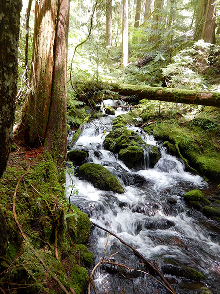
August 17
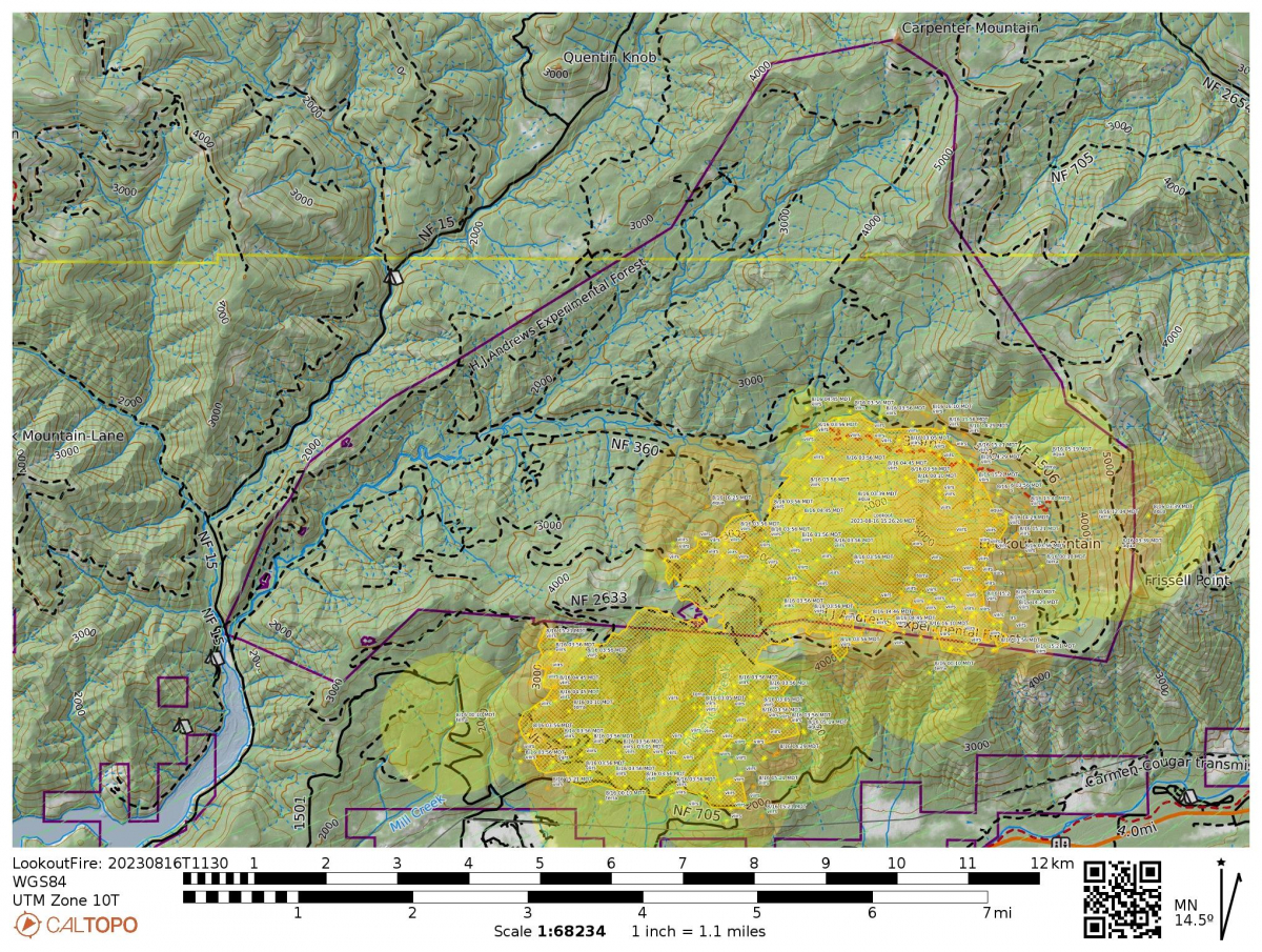 Surprisingly, a light rain fell over the area this morning (about 0.05 inches recorded at PRIMET, our climate station at the headquarters facility). The fire continues to burn, and now covers 4,271 acres. That number includes a significant area outside of the boundary of the experimental forest.
Our webcams show thick smoke. That will change with shifting winds. The weather forecast on InciWeb is that "Conditions are expected to continue to slowly moderate on Thursday, but it will remain abnormally hot and dry with a heat
advisory continuing until 10 PM Thursday. General winds will become more westerly and this may help to ventilate the fire and push more of the smoke out to the east. There is still a small chance that a thunderstorm could cross the Cascades near the fire Thursday."
From today's Lookout Fire Operational Briefing: They're making good progress on SW side of the fire, tightening the lines, with a goal of minimizing acreage of fire and protecting private property and the HWY 126 corridor. Yesterday a spot fire crossed the line on the NE side; crews are getting on it today to manage it. Crews have completed structure protection in the Level 3 evacuation area, which is north of HWY 126. Brush has been removed from next to houses. Crews were working at HJA headquarters yesterday and the facility is "plumbed in and ready to go." Thank you, fire crews!
A Look Before the Lookout Fire. Post 3. The Lookout Creek Old Growth Trail.
Did you ever hike the Lookout Creek Old Growth Trail? John Cissel, then in his role as the Research Liaison with the US Forest Service, conceived and planned the Lookout Creek Old Growth Trail over 30 years ago as a way to connect the HJA with a broader public. John writes, “It took a lot of help from our friends, but we successfully added sections of new trail at each trailhead that connected to an old, unmaintained administrative trail that ran across the slope of lower Lookout Mountain. Today is the day I had scheduled for my annual return visit to the old growth along the trail, but now I don't know when I'll see my old friend again, or what it will look like when I do. Anyone interested can see my description of the trail and photos on my website.”
The Lookout Creek Old Growth brochure provides natural history information about the forest seen from the trail, prior to the fire. A virtual tour of the old-growth trail leads viewers through the ecosystem (pre-fire) and some of the essential characteristics of an old growth forest. Note: the trail is closed now due to the fire.

August 16
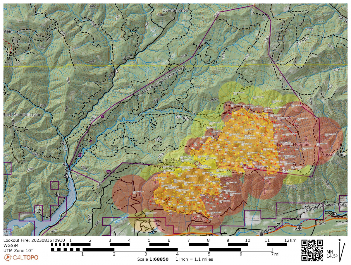 Today's InciWeb report lists the fire at 3,710 acres (1,500 hectares). "The Lookout Fire has moved north toward Lookout Creek but has not crossed it. Strategic firing operations on Forest Service Road 700 were successful and the fire is still north of the road. Heavy smoke moderated temperatures and fire activity yesterday. Smoky conditions are expected today with the possibility of lifting with west winds. If smoke clears, fire activity has the potential to increase. Task forces continued surface preparation, triage of structures, and conducted overnight patrols along the 700 road to monitor the fire. Crews also completed preparations on the HJ Andrews Forest Compound, including sprinkler installations and vegetation clearing." Today, crews continue to prepare and monitor containment lines in addition to preparing structures at HJA and in the nearby communities.
The official Lookout Fire 2023 Facebook page has photos of fire crews at work on the 700 road, holding the line, in very smoky conditions. Our webcams continue to show views of Lookout shrouded in thick smoke. The fire map indicates that most new fire activity is to the south, with some fire activity at the east edge where fire crews are doing controlled burn backs to prepare a containment line.
The emergency closure order issued for the Lookout Fire area on the Willamette National Forest has been expanded for public and firefighter safety. Read full closure.
A Look Before the Lookout Fire. Post 2. High Elevation Meadows and Pollinators.
Did you know that the HJ Andrews Experimental Forest, and Lookout Mountain, has high elevation meadows? Those meadows are full of flowers in the summer. Researchers have been studying how pollinators — like bees, flies, moths and butterflies — are connected to flowering plants and how networks of plants and pollinators respond to environmental change. So far, research in 12 meadows, over 11 years, has identified >670 flower-visitor species and >150 species of flowering plants. Pollinator diversity stays somewhat constant despite variation in climate, numbers of pollinators, and diversity of flowers that they visit. The Plant Pollinator Study started in 2011. Four of the twelve long-term plant-pollinator study meadows are on Lookout Mountain, within the area of the Lookout Fire.
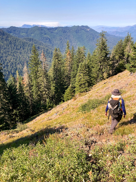
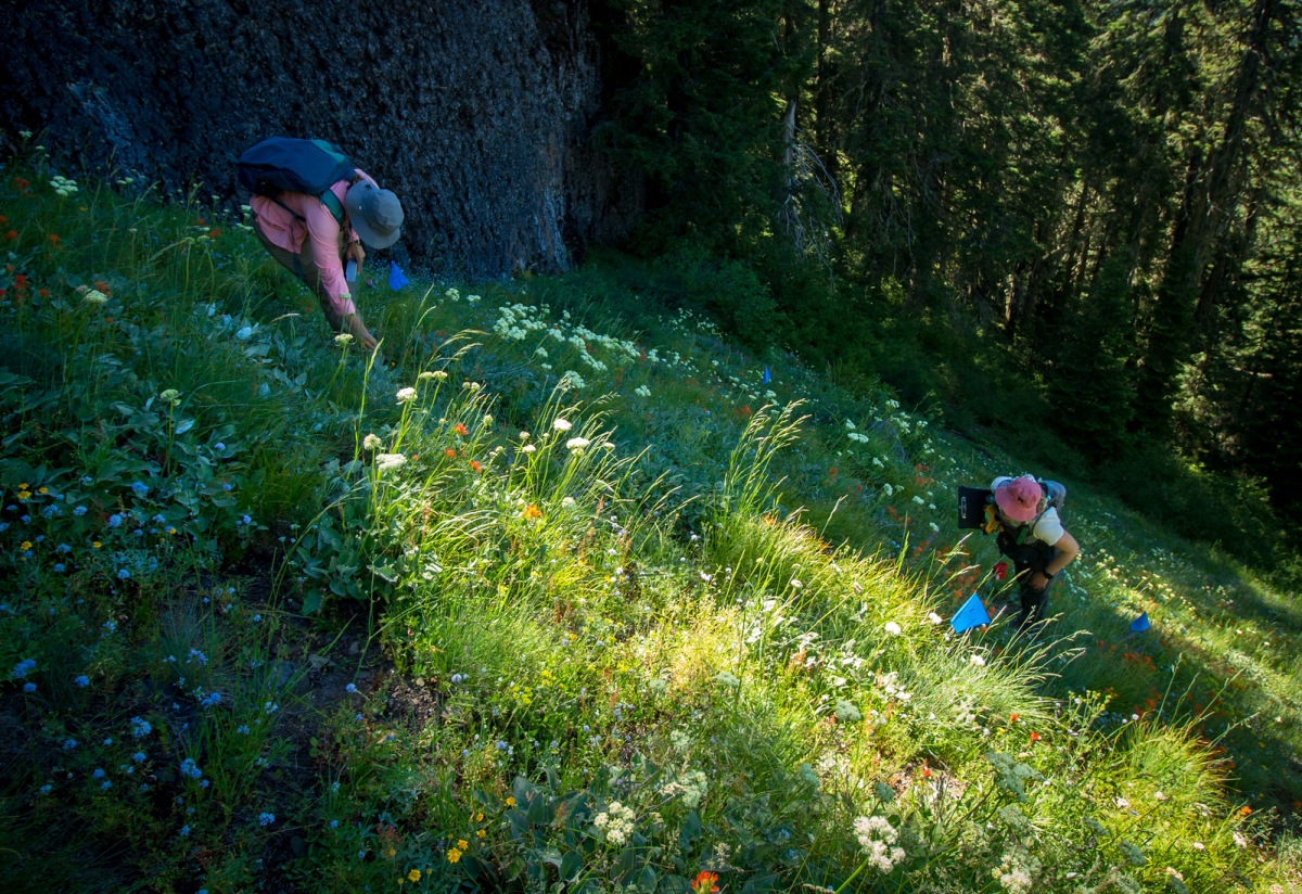
August 15, evening
A HUGE thanks to the fire crews who spent the day setting protections around the headquarters and facilities. Check out the official Lookout Fire 2023 Facebook post, below, with photos of the fire crews at work. It's exciting to see images of headquarters and the fire protection activities in action. And, look, the Mack Creek gauge station still stands! Hooray! The Mack Creek gauge station measures the volume of water passing through the creek. Scientists also collect water samples to assess the chemistry and any sediment in the water. That information has been collected regularly since 1980 as part of a long-term record on streamflow and stream chemistry. The information has, over the years, helped us learn about how water moves through watersheds, hillslopes, and riparian areas, and how water movement and chemistry change with forest harvest, natural disaster, and climate change.
Note, in the photo below, that the person on the right is Greg Downing, the US Forest Service hydrologic technician who has been working at the HJ Andrews Experimental Forest for decades. Greg is serving as a resource advisor to the fire crews. We appreciate the partnership and opportunity to help and provide input on efforts and protections.
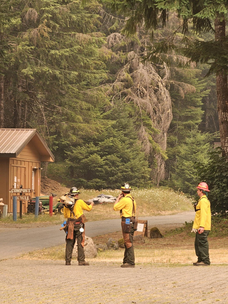
August 15
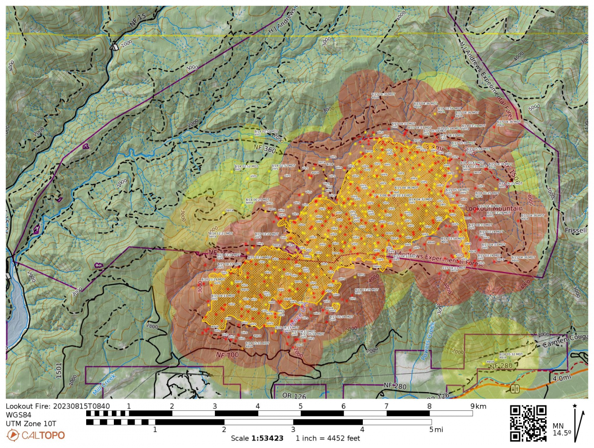 Today's InciWeb report:
- Size: 2,720 acres
- Total personnel: 403
- Resources:
- 9 Engines
- 9 crews
- 7 bulldozers
- 7 water tenders
- 4 helicopters
"The fire has remained within primary control lines and stayed north of Forest Road 700. Firefighters started strategic firing operations from Forest Road 700 overnight to consume fuel between them and the fire, slowing fire spread. The fire backed down to Lookout Creek. Firefighters will use the creek as an anchor point to prevent fire spread." "Firefighters will continue preparation work on Forest Road 700, using heavy equipment to ensure the fire stays north of the road. Firefighters are scouting nearby roads to connect primary control lines. Aviation suppression resources will continue to be used to slow fire activity while crews work on the ground. OSFM resources are working on the south end of the fire and working near homes on Taylor and North Bank doing triage and preparation, as well as assisting wildland resources." The IR map shows activity south of the HJA boundary and north of the 700 road.
Webcams show views obscured by smoke. Winds are lower today, which may slow the rate of spread of the fire.
August 14, evening
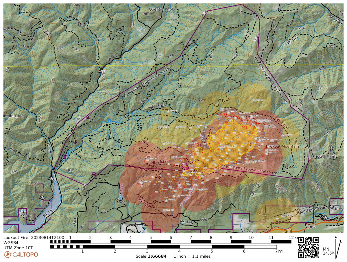 CalTopo maps show that the fire expanded significantly into the HJA and southwest into the McKenzie Valley area. Last night's Level 2 evacuation orders remain in effect for the area north of HWY 126, and today Level 1 evacuation orders were set for the area south of the highway. Much of the area was thick with smoke.
This afternoon, the Andrews Forest research community heard from Brooke Penaluna, Lead Scientist for the H.J. Andrews Experimental Forest with the USFS PNW Research Station. Brooke provided a comprehensive update on the extent of the fire thus far, projections of what the fire might do in the coming days, and information on evacuations and closures. After the briefing we gathered to process what's unfolding. We shared our concern for our colleagues who live on the HJA site and are displaced from their homes, for our site staff who live in the McKenzie River community and have had to evacuate their homes, and for the surrounding communities of the McKenzie Valley who are facing wildfire evacuations so soon after the devastation of the 2020 Holiday Farm Fires. We used words like shock, grief, and sadness, and spoke of what it is to balance being scientists who, in our minds, understand that lightning-initiated wildfires are a natural part of our forest ecosystem, and yet, in our hearts, feel a great loss for a place that we care for deeply.
With that caring in mind, we’ll begin to share more on this webpage about the forest, and what was there, before the Lookout Fire.
A Look Before the Lookout Fire. Post 1.
A story map created by graduate student Alyssa Eklund contains videos, infographics and basic information about wildlife: “Nature's Hidden Encounters: Unveiling Wildlife Biodiversity - Large Wood Crossings at Lookout Creek, H.J. Andrews Experimental Forest, OR”. Much of the video footage and photos come from areas that are now within the Lookout Fire perimeter. This study shows that large logs laying across streams serve as important corridors to many different species of animals.
August 14, morning
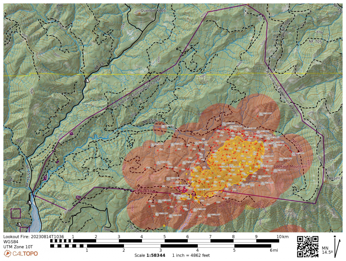 Today's InciWeb reports that the fire is at 1200 acres, 0% contained. The fire grew significantly overnight with winds and hot temperatures. "Red Flag conditions caused the fire to increase in activity yesterday and burn actively into the evening. Winds shifted out of the east and were reported to have gusts up to at least 25 mph. This caused fire embers to travel distances of up to 1 mile, causing additional ignitions west of the fire. In the early evening, the fire crossed over the top of Lookout Ridge."
Oregon Governor Tina Kotek invoked the Emergency Conflagration Act for the Lookout Fire. The move allows the Oregon State Fire Marshall to mobilize firefighters, equipment, and the Blue Incident Management Team to protect life and property.
Fire crews continue to cut containment lines and scout other indirect options of control, with a priority of safety for fire crews and keeping the fire out of the nearby communities of McKenzie Bridge and Rainbow. "Today’s activities: Type one helicopters will continue to support operations on the fire with water drops while crews and heavy equipment continue to construct primary and secondary firelines. Crews will continue utilizing roadways and previous burn units as a secondary option. Structure protection in and around the fire area is in place. Today’s weather is predicted to be warmer than yesterday. This may cause fire behavior to be more active and smoke to be more abundant."
Caltopo Fire Maps indicate that the fire may have reached as far as the confluence of Mack Creek and Lookout Creek.
Webcams show a thick column of smoke and a fire area spread across the flank of Lookout Mountain.
Lookout Fire Facebook page, with official fire information managed by incident communication officers, includes flyover videos, daytime and nightime.
Lane County Sherrif Office evacuation and closures of the area, including HJA, remain in effect.
August 13, 10:30 PM
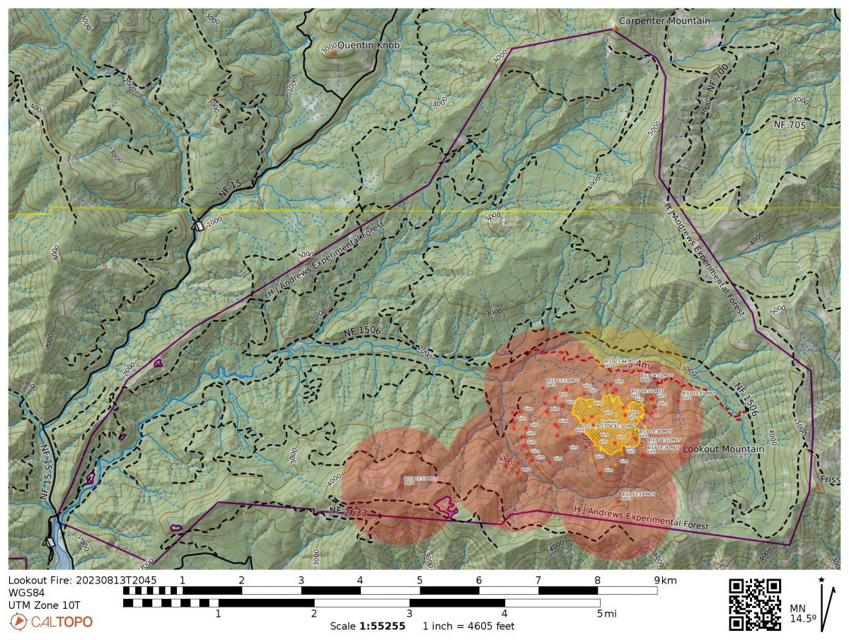 Everyone from HJA headquarters is out and safe.
On Saturday, HJA was notified that it was under closure. A small group of people from our HJA community came from Corvallis to help with packing up the headquarters as part of pre-evacuation measures. We thank Oregon State University Motorpool because they generously comped the 4 vehicles that our helpers drove and packed. The small group arrived at headquarters early Saturday morning to pack up artwork, signed books, expensive equipment, and special items. Heavy machinery was also moved offsite.
All researchers, students, and crews left HJA by late Saturday evening. Only core staff remained.
Moving into today, the fire started spreading out. Tonight, just a few hours ago, there was a level 2 evacuation ordered for HJA and neighboring areas, including the two campgrounds right outside HJA. We had already established that at level 2 everyone would leave headquarters. Mark Schulze, our Forest Director, did a final sweep and was the last one out. At 10:30 PM tonight, headquarters moved to a level 3 "go now" evacuation order; everyone was already out and safe by that time.
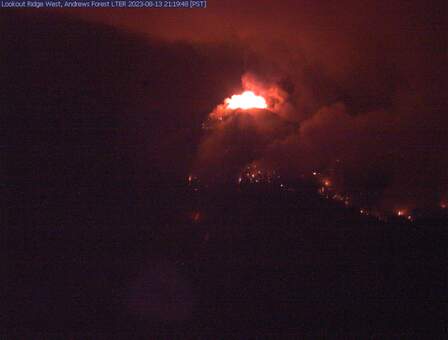 Webcam activity shows intense fire activity on the top of Lookout Mountain, with hot temperatures and winds feeding the fire.
August 13
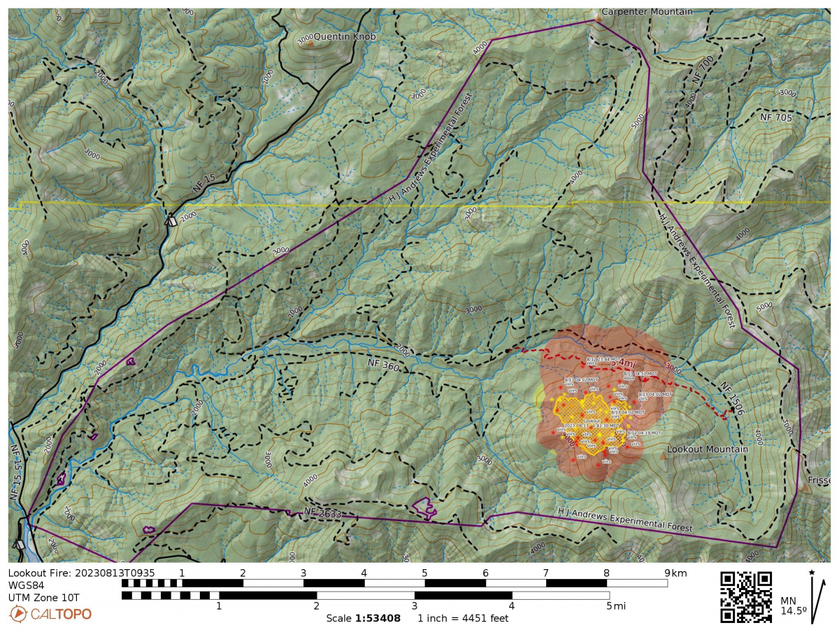 Webcams show increased smoke and fire activity.
Today's InciWeb report includes:
Size: 195 acres
Total personnel: 235
Resources: 3 Engines, 7 crews, 3 bulldozers, 3 water tenders, 3 helicopters
"Today the Lookout Fire transitioned from Nevada Team 1, a Type 3 Incident Management Team, to Northwest Team 6, a Type 2 Incident Management Team. The fire was less active overnight. Fire managers have assessed the area and deemed that due to steep slopes with rolling materials, inaccessibility, and exposure to snags, it is safer for firefighters to pursue an indirect suppression strategy. Implementing an indirect suppression strategy means firefighters will be able to use strategies like using ridges, roads, and heavy machinery to have a greater chance of success in keeping the fire as small as possible as conditions change.
Today’s activities: Firefighters have scouted and identified areas around the fire that provide for safety and have a high probability of success to engage with the fire. Crews are continuing to construct fireline while also removing small trees and brush along existing roadways surrounding the fire. Aviation will continue to be used to slow the progression of the fire. Smoke may be more prevalent in the next few days with reg flag conditions predicted. These weather conditions could also contribute to more active fire behavior."
The HJA site and facility is closed for all research purposes. We continue to maintain streaming weather data and webcams, which are assisting the fire team with real-time assessments.
August 12
Today was a busy day on the fire. The fire area grew to an estimated 140-200 acres. Given the growing size of the fire, and the forecasted winds and hot temperatures, additional firefighting resources are being assigned to the Lookout Fire.
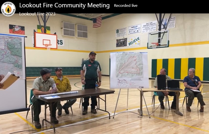
The Lookout Fire Community Meeting (see online recording) introduced the team and shared facts and information on the fire. To date: 236 personnell assigned, more en route. 4 helicoptors. 77,735 gallons of water dropped on the fire over the last 5 days. Zero injuries or accidents. Number one priority is holding fire off Lookout Ridge, to protect the McKenzie Bridge community. Crews are cutting line by hand and with heavy equipment. Note that the best case scenario puts the fire at 30% of the HJA area. The fire team notes that the fire has been hard to fight directly given the rugged terrain, 60% grade, tall trees and snags, and remote location that takes more than five hours to access by foot.
Huge thanks to the crews and incident command for their communication with HJA staff and the community, and for their efforts in challenging conditions.
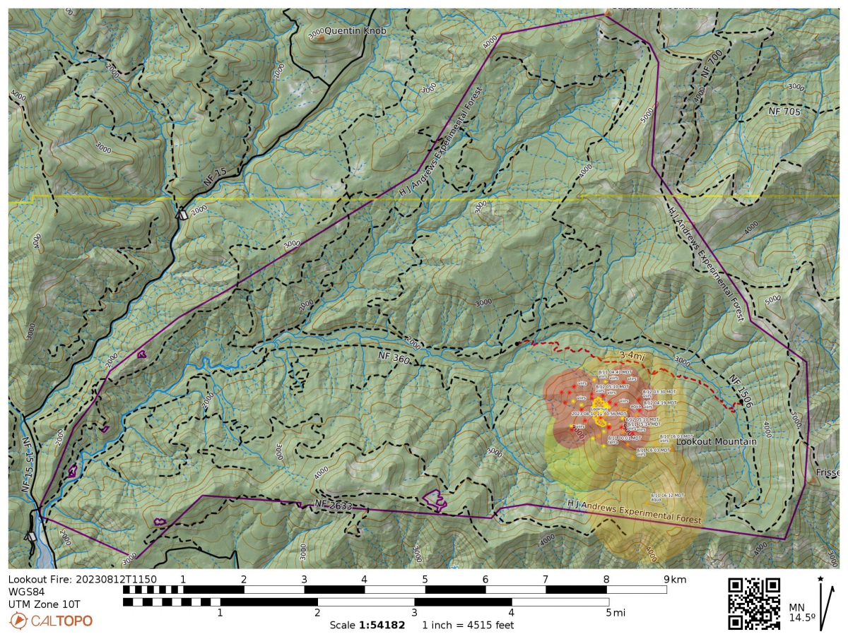 As of today, areas within the HJA are officially closed: For the safety of the public and firefighters, the current closure area includes Frissell North trailhead, Lookout Creek Trailhead (East and West), Carpenter Mountain Trailhead, Lookout Creek Trailhead #4105, Carpenter Mountain Trail #3302, and a portion of Frissell Trail #3512. We anticipate additional closures in the next week.
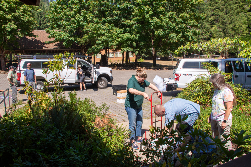 We evacuated headquarters today. All field crews and temporary residents moved out. Displaced crews and students found housing with Oregon State University summer housing and Forest Service space. A small crew went to headquarters to work with site staff to pack up irreplaceable and expensive items like historical documents and photos, artwork, and research equipment. The items were transported to Corvallis for storage.
Weather this week is forecasted to be hot, with east winds, which can feed the fire.
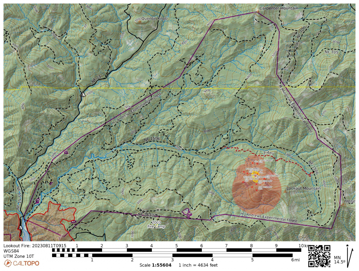 August 11
A community meeting will be held on Saturday 8/12/2023 at 6:30pm. Location: Mckenzie High School at 51187 Blue River Dr, Vida, OR 97488
Today's InciWeb update: "The fire picked up in activity around 4pm yesterday and remained active into the evening. It has continued to burn across the slope, putting up a consistent column of smoke. With the forecast showing increasing temperatures and winds combined, we encourage the public to be alert and continue to check the Lane County website: www.LaneCountyOR.gov/LookoutFire and the Willamette National Forest Facebook page for updates about the fire. Additional firefighting resources are arriving on the incident as other fires are winding down. The public should anticipate the area to increase in traffic over the course of the weekend as more resources are staging in the area. Particularly along Highway 126 between Old Scout Road to Blue River Reservoir and up to McKenzie Bridge State Airport. Also, as of this morning, the Mackenzie Bridge State Airport is closed to allow crews and equipment to ramp up Fire Camp at the site. Other closures are forthcoming so please be patient as cooperators gather intelligence to include only the vital information on them."
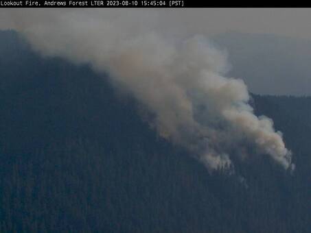 August 10: new webcams
New Lookout Ridge and Lookout Fire cams are online, thanks to the hard work of Adam Kennedy and Mark Schulze. See https://andrewsforest.oregonstate.edu/about/webcams
August 10: SITE CLOSURE
From Paul Anderson, Station Director of the USDA Forest Service Pacific Northwest Research Station, 8/10/2023:
"The Lookout Mountain fire within the HJ Andrews Experimental Forest continues to elude containment as fuel loading, topography, and access limitations impede mitigation and suppression efforts. Researcher and staff access to the upper watersheds within the forest have the potential to impede fire operations activity and exacerbate personnel safety concerns. With the forecast showing increasing temperatures combined with lack of containment I am directing that all researchers (Forest Service, university, and any other recognized research partners or collaborators) and staff access to the HJ Andrews Experimental Forest will be constrained in the following ways:
As of 17:00, Thursday, August 10, 2023, all field activities, accessed by road or trail, by foot or vehicle, are to cease throughout the experimental forest and will not resume until further notice as provided by the site manager, Mark Schulze.
Researchers and staff temporarily housed in HJ Andrews facilities will vacate the premises and headquarters compounds by 17:00, Sunday, August 13, 2023. Facilities and compound grounds will remain vacated untill further notice as provided by the site manager, Mark Schulze.
Exceptions to this directive are limited to staff or researchers working in direct service to and at the request of fire operations staff, as vetted by Nora Miebach and as coordinated through the site manager Mark Schulze and Lead Scientist Brooke Penaluna.
The timing of field access and facilities use restrictions may change or be accelerated by further decisions of fire operations staff, the District Ranger, or the PNW Station Director.
These measures are undertaken to promote the safety of all persons, researchers and fire operations, and facilities in a dynamic fire situation. Your cooperation is very much appreciated."
August 10
Today's InciWeb update states, "An Infrared flight took place last night and the fire perimeter and interior are still showing significant heat. The fire is putting up smoke and was most active in the evening yesterday. The incident is experiencing some rollout from the steep slope as debris is loosened by the fire. The Incident Management-Operations Team had crews continuing efforts to find ways to safely use a direct attack approach on the incident, along with scouting operations to improve/shorten the ground access to the fire. Also, multiple locations were evaluated for aerial access to assist in the direct attack strategy. In addition, multiple options are being considered and prepared for indirect attacks as well. These strategies were determined to be the best balance of protection for the values at risk and firefighter safety."
Safety and Closures: "The Lookout Fire would like to caution the public driving on Highway 126 and Forest Roads 1506 and 1507. Fire equipment and contractors are traveling in and out all through those passes which increases the risk of an accident. Please avoid the area when at all possible. Although there are no road closures in place at this time, one can be expected in the near future."
August 9
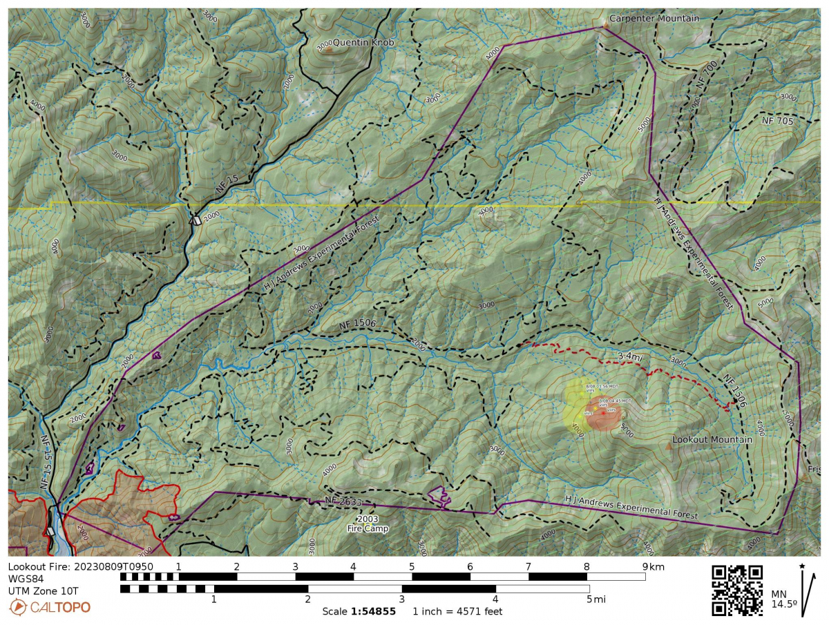 Today's InciWeb update reflects the difficult conditions for firefighters: "Operations staff continued to scout and look for options for direct attack. Helicopters dropped 25,000 gallons of water to slow the progress of the fire. Heavy helicopter water drops are having a tough time penetrating through the dense overstory canopy which is also increasing the likelihood of tree falls near the fire. Multiple snags and widow makers are lining the fire perimeter and actively collapsing during suppression efforts, thereby directly affecting firefighter safety....Other challenges include the steepness of the terrain (60% slope) with a gain of 1,470 in elevation on the ground approach. This leaves aviation as the only realistic option for bringing sufficient water to the fire to cool it, at this time."
While the area is not under closure yet, we encourage everyone to stay off the 350 road and the 1506 road east of the 350, which has a lot of activity that we do not want to impede. We strongly discourage use of the Lookout Creek Old Growth trail.
Mark Schulze and Brooke Penaluna spent a lot of time today with the incident management team as they continued careful planning for contingencies and balancing safety with managing the fire for the best possible outcome. It’s a great group and they are working very hard in difficult circumstances. We are lucky to have this level of support this early into a fire, especially given all the other fires around us.
Thanks to quick work from Greg Cohn and Adam Kennedy we were able to contribute data from our long-term climate stations to help the incident management team receive an accurate spot fire weather forecast for the fire area tomorrow. We will continue to look for ways to contribute to this effort, even if it mostly means giving the team space.
August 8
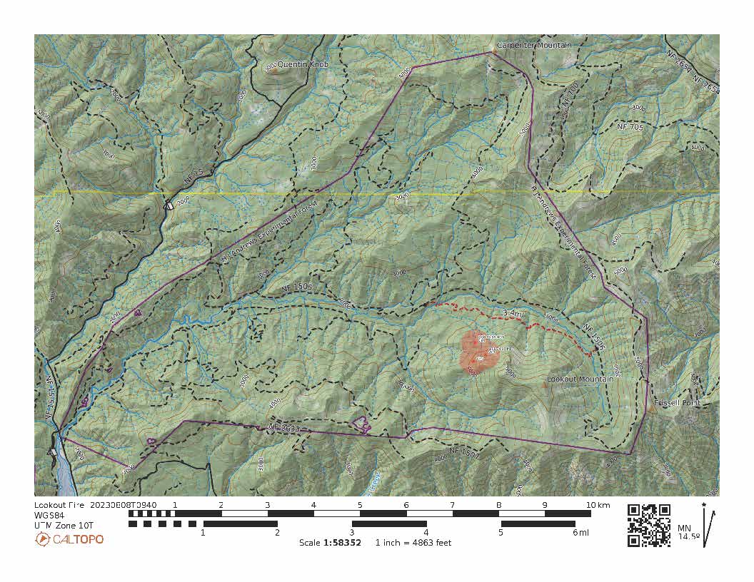 The new InciWeb page for the Lookout Fire is: https://inciweb.wildfire.gov/incident-information/orwif-lookout-fire. Deathball mountain cam may show images of the fire: https://www.alertwildfire.org/region/oregon/?camera=Axis-DeathballMtn.
From today's InciWeb's report: "
"Crews are in the Initial Attack phase of the incident response. The fire is located on a 60% slope, within a thick stand of green and dead/broken-top trees accompanied by an old-growth (HJ Andrews) experimental forest.
Challenges include steep, rugged, rocky terrain and a thick canopy on an east-facing slope that is making access by both air and ground difficult. The fuel loading in the area is hindering suppression efforts significantly. The fires' fuel type is heavy timber with an extremely thick-canopied tree stand, all within a study area that hasn't had a significant burn in it for over 100 years. Deep, thick timber litter/duff (3-5 ft.) with multiple scattered tree limbs/branches throughout the ground level, consume the area. Thick brush and shrubs combined with severely overgrown grasses/weeds litter the ground floor.
Crews have secured access to the fire's edge by creating over a mile of escape/safety line, through dense underbrush but are having a hard time engaging due to the severity of the risks involved with the vegetation and snags. Some of the dead trees around the area have been lightning and tree struck and show signs of splintering from top to bottom.
Yesterday, the fire was most active on the north and northeast flanks. Helicopters dropped water on the fires' perimeter to slow advancement. As of yesterday evening, crews were able to create minimal handline on the bottom of the fire. The incident was most active between the hours of 1pm and 5pm."
August 7, 2023
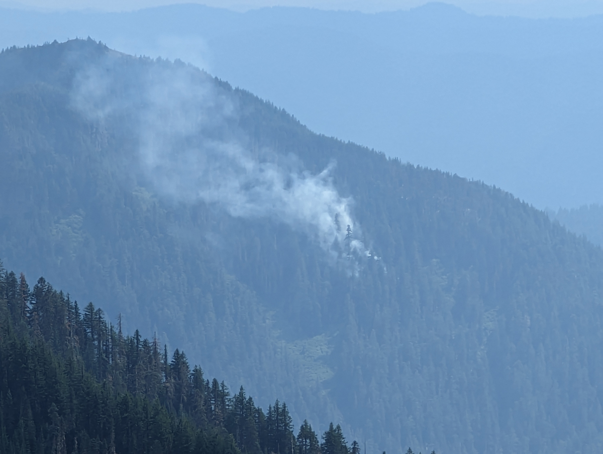 A lightning strike fire started on Saturday, August 5, within the H.J. Andrews Experimental Forest, between the base of Lookout cliff and the ridge dividing Lookout and Mack Creek drainages. As of today, August 7, the fire is 2.5 acres. Two helicopters are traveling between the Blue River reservoir and the fire carrying water. The plan is to keep knocking back the fire until ground crews can get a line around it and contain it. It is burning in steep terrain, in old growth with dense understory, which is making it a challenge for experienced ground crews. In addition to the helicopters, a hotshot crew has been assigned to the fire, most likely starting August 8.
Check the Eugene Interagency Communications Office for updates on size and containment.
Researchers and the public are advised to stay out of the area, including the Lookout Old Growth trail, to allow fire crews space and access. We are anticipating a fire closure on site.
Researchers and public should be ready to evacuate if we move to a level 1 evacuation level. Anyone working on site should have a radio on at all times.