Climate Stations
Benchmark and Secondary Meteorological Stations
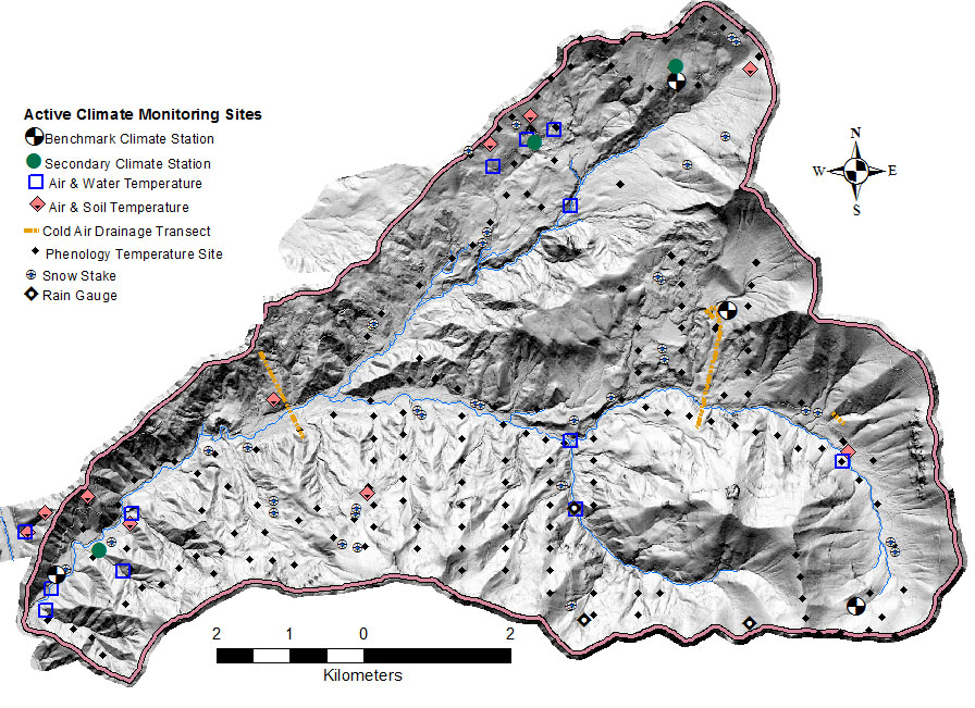
Four benchmark climate stations provide a full suite of common meteorological sensors for measuring air and soil temperature, relative humidity, solar radiation, wind, snow depth and water equivalent, and soil moisture. The primary met station at Andrews Headquarters also contributes precipitation samples to the National Atmospheric Deposition Program (NADP; Site OR10). Secondary climate stations contain a more limited number of sensors, but include the two longest-running temperature and precipitation monitoring sites on the Andrews Forest. Quality assessed datasets from climate stations are available under study code MS001 and provisional graphs and data can be accessed in near real time. Extensive documentation of climate station history and sensor configurations is available under MS001 study description and explanations of variable names, probe codes and QA flag codes can be downloaded as a PDF or EML file. Given the large number of data streams, the evolution of stations and sensor types over time it is highly recommend that data users read and understand associated metadata prior to conducting any analysis meant for publication.
MS001 - Meteorological data from benchmark and secondary stations at the Andrews Experimental Forest, 1957 to present
Undercanopy Temperature Stations
A large number of air, soil and water temperature measurements are taken underneath the forest canopy for a range of objectives:
HT004 - Stream and air temperature data from stream gauges and stream confluences, 1950 to present
MS005 - Air and soil temperature data from the Reference Stand network at the Andrews Experimental Forest, 1971 to present
MS036 - Cold air drainage transects, 2002 to present
MS045 - Air temperature at core phenology sites and additional bird monitoring sites, 2009 to present
Supplemental Snow and Precipitation Sites
To improve spatial resolution of snow and precipitation measurements additional rain gauges and snow stake measurements have been used to supplement data from climate stations.
MS007 - Snow depth and snow water equivalent measurements along a road course and historic snow course in the Andrews Experimental Forest, 1978 to present
MS004 - Precipitation measurements from historic and current standard, storage and recording rain gauges at the Andrews Experimental Forest, 1951 to present
Additional rain gauges are active at the Mack Creek gauging station and on the 1507 road. Historic precipitation data are available from gauges that have been discontinued. Contact the Andrews Information Managers to request supplemental precipitation data.
Real-Time Data
Provisional, real-time, streaming data are available for most climate stations. See our Real-time Data pages.
Climate Monitoring Methods Viewer
The H.J. Andrews Climate Station Methods History tool can be used to view the data collection methods that have been used over time at select climate stations. Results can be filtered by parameter, climate station, and date range. A general text search is also available.