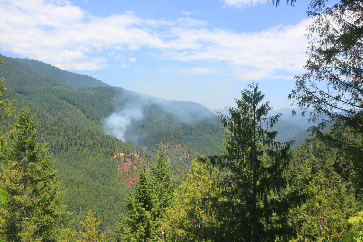
Ore Fire Updates 2024
Related links: Inciweb | Ore Fire Information on Facebook | CalTopo | WatchDuty
September 16
From Inciweb: 3,475 acres, 76% contained. “Following the successful firing operations below the Forest Service Road 1509, crews continue chipping efforts and removing combustible material. Minimal fire activity was observed with smoldering and smoke along the northern side.”
Cooler weather and rain, combined with extensive efforts of fire crews, have contained the Ore Fire. The fire has not spread into the H.J. Andrews Experimental Forest. Research crews have been allowed to make targeted visits into the experimental forest to collect critical data.
Darren Cross, District Ranger of the McKenzie Ranger District, has been an important partner in prioritizing protection for the HJ Andrews Experimental Forest and in finding ways for research to continue, in close communication with incident command on the fire. In the video below, Darren Cross talks about the H. J. Andrews Experimental LTER program and how its research findings can be used for future firefighting.
September 6
The current heatwave and red flag conditions have increased fire activity on the Ore Fire. Fire personnel are working day and night to maintain firelines and prevent the spread of the fire. Closures to the area remain in effect. Willamette National Forest closures for all fires can be found here: Willamette National Forest - Alerts & Closures (usda.gov) Specific closure maps for the Pyramid Fire can be found here. Specific closure maps for the Ore Fire can be found here.
From Inciweb: 3,319 acres, 42% contained, 577 total personnel. "Fire personnel continue to monitor weather conditions with hot and dry temperatures in effect. The Ore drainage off the 1509 road continues to be a critical piece of the fire. Firefighters will continue to patrol, monitor, and mop up to secure fire lines."
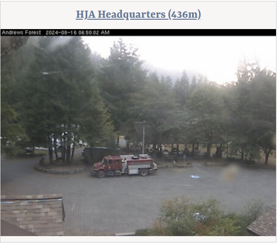
HJA webcams show smoke in the area, and fire crew vehicles at headquarters.
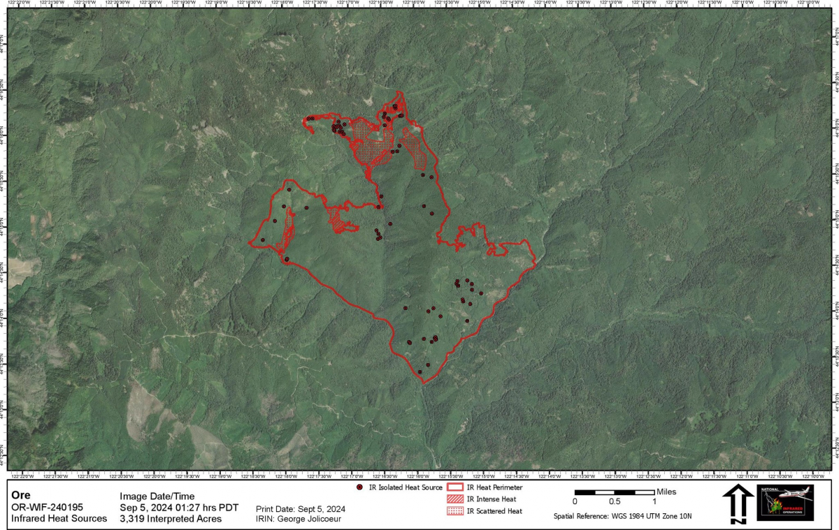
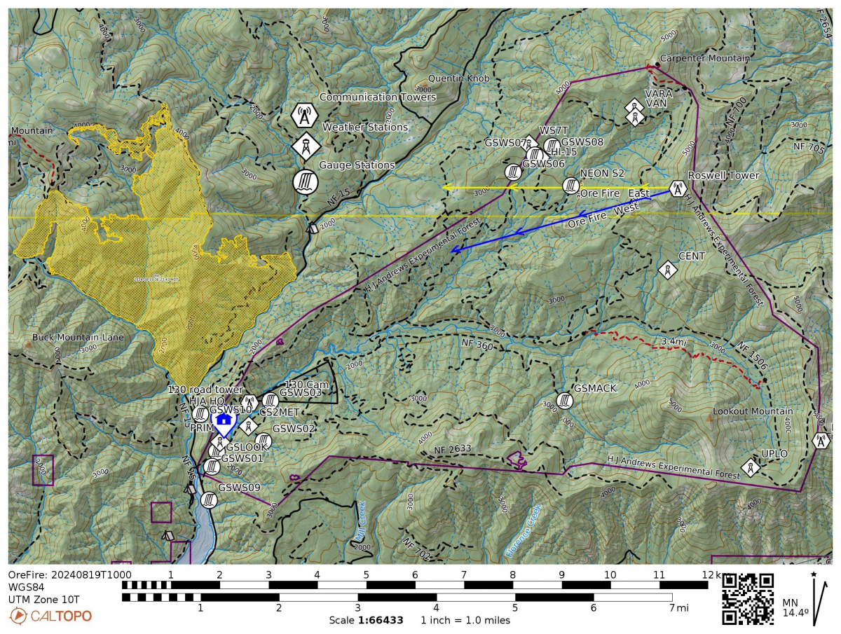
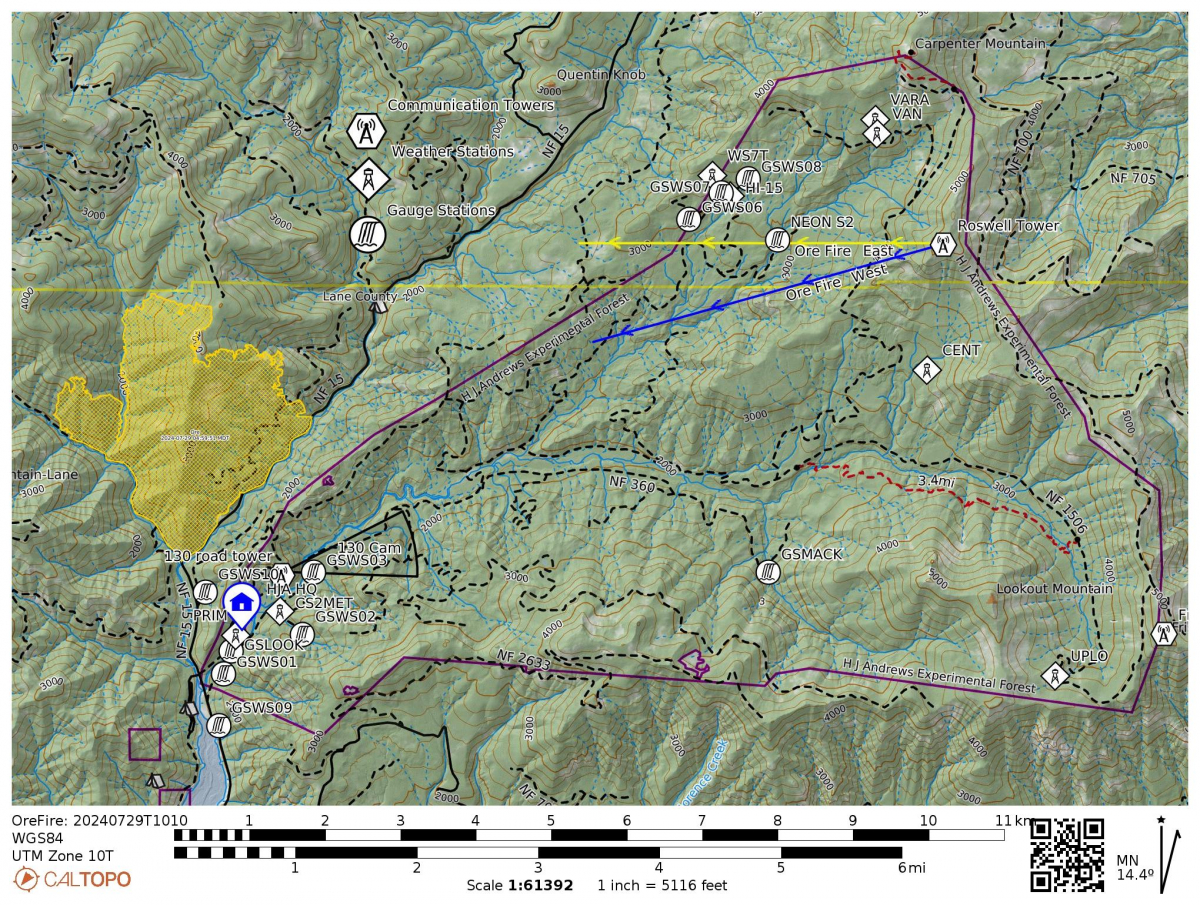
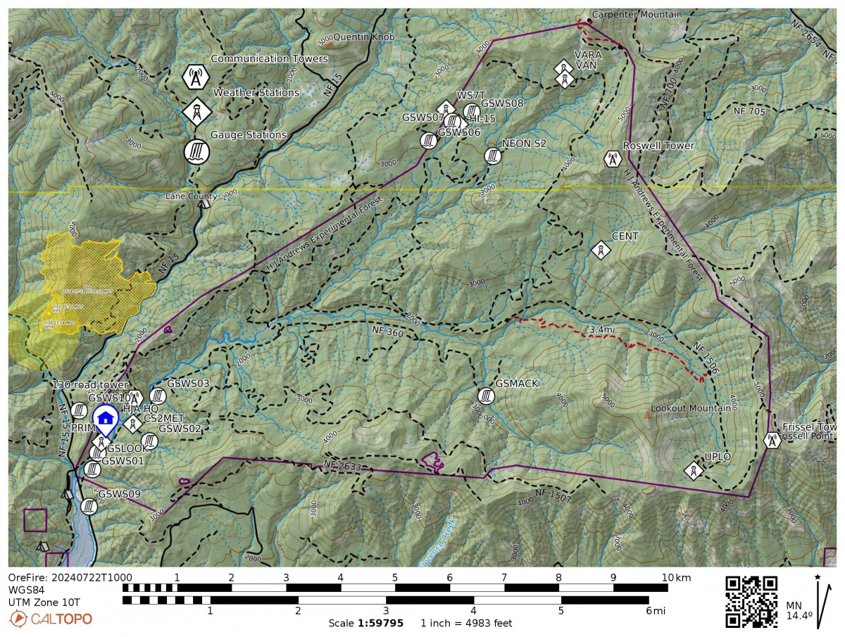
The map, below, from the Forest Service, displays areas of active heat and fire activity on the Ore Fire, mainly on the west and northwest edges. The HJA Experimental Forest, to the southeast of the Ore Fire, is away from the active fire and heat. Click on the image to bring up a full sized view.
August 29
From InciWeb: 3,155 acres, 28% contained, 639 total personnel. “Personnel patrolled the line and found few active hot spots in the areas of concern they investigated. Smoke was located within 100 feet of the line in 1 area and fire crews extinguished it. Air operations made thirty-three bucket drops and performed reconnaissance work to monitor the fire. Firefighters made major progress in fuels reduction yesterday, completing hauling on the 130 road and hazardous fuel removal processing on the 877 road. Crews are reducing fuels on the 1509 road."
"Warmer, drier weather in the next three days is expected to increase fire behavior. Meteorologists predicted sustained winds of 20-25 miles per hour on ridgetops within the incident area overnight, leading to increased night patrols and additional engines assigned to monitor and mop-up any wildfire spread near the fire line overnight. Crews are improving containment lines by reducing fuels through mastication, chipping wood, and hauling fuel to landings away from the fire. Firefighters are also constructing additional direct fire line to improve fire containment. Pockets of heat in dense fuels remain within the interior of the fires and teams are developing plans to attack the fire in its steepest and hardest to access areas."
August 28
From InciWeb: 3,152 acres, 28 % contained, 627 total personnel, human caused. "Crews continue to scout viability of direct hand line construction, mop up, and secure containment lines. Overnight crews continue to patrol and secure containment lines. On the northwest and northeastern corners of fire containment lines were strengthened and improved. Hot spots along the patrol routes were doused. Contingency resources are working on fuel break improvements, chipping, masticating, and improving handline construction."
Generally, the cooler weather and higher humidity has allowed for crews to strengthen fire containment lines and fire progression has been minimal. Forcasted weather for this week is lower humidity, warm conditions, and wind.
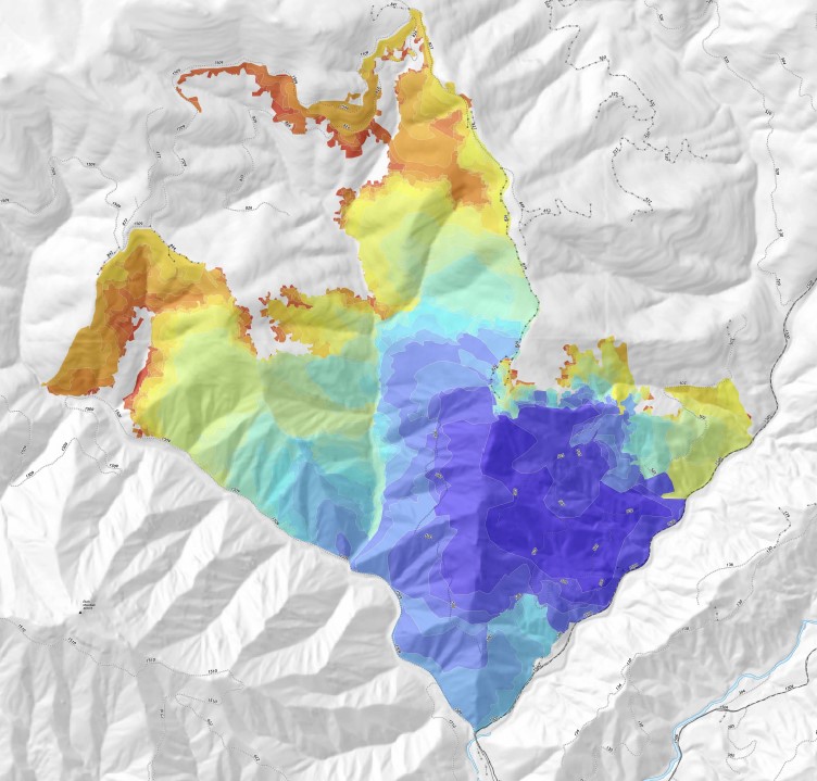
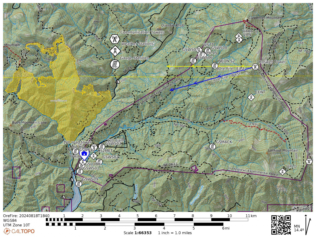
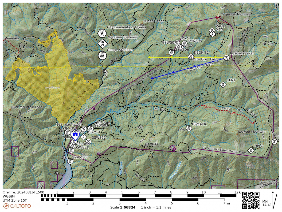
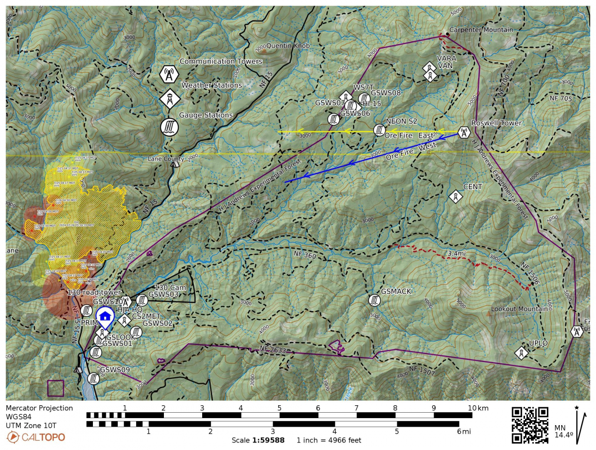
This fire progression map, from the Forest Service, shows how the Ore Fire has been moving over time, gnerally from the south to the north and west. Click on the image to see a full view PDF, including the legend for the colors.
August 23
From InciWeb: 3,140 acres, 16% contained, 671 total personnel. "The Ore Fire area received 0.56” of rain last night. Day and night shift resources continue to secure containment lines. Current weather and fuel conditions are too wet for firing operations which would continue to increase the fire perimeter containment percentage. Crews on the northeastern flank will continue to construct and improve containment lines, while crews on the east and west flanks will strengthen existing and create new contingency lines. A contingency line is a secondary or alternate strategic fire line, which is created as a back up to the primary fire line, based on current needs and conditions. The southwestern and southeastern areas remain solid barriers to fire spread." More rain may fall today.
August 22
From InciWeb: 3,140 Acres, 16% Contained, 668 Total Personnel. "Day and night shift resources continue to secure containment lines. Current weather and fuel conditions do not support additional firing operations which are required to continue to increase the fire perimeter containment. Crews on the northeastern fire area will continue to construct and improve containment lines, while crews on the east and west fire areas continue to strengthen existing and create new contingency lines. The southwestern and southeastern areas remain solid barriers to fire spread."
Given the slow movement of the fire, and the chance of wetting rain today and into Friday night, there may be an opportunity for limited researcher access to the HJA, to collect samples that are critical to ongoing research that was interrupted by the site evacuation on July 17. Typically, in the summer, the research site is full of scientists and students researching soil, carbon, water, fish, climate, tree growth, water movement, and more. The HJA Site Director is in close communication with fire management personnel to manage access, escort, and safety measures for all possible researcher trips and any access must go through these channels.
August 21
From InciWeb: 3,147 Acres, 14% Contained, 571 Total Personnel. "Overnight resources continued to secure containment lines. Current weather and fuel conditions do not support the additional firing operations required to complete securing the fire perimeter. Crews on the northeastern flank will continue to construct and improve containment lines. The southwestern and southeastern flanks remain a solid anchor for the fire."
August 20
From InciWeb: 3,135 Acres, 14% Contained, 571 Total Personnel. "Conditions will be warmer and drier today leading to an increase in fire activity ahead of predicted wetting rain later in the week. There are confirmed new lightning fires in the area, and incident resources are available to assist with new fire responses if necessary." On the Ore Fire specifically: "Overnight resources continued to secure containment lines. If conditions prove favorable, crews will resume firing operations today along the 1509 Road to strengthen the northwestern flank. Crews on the northeastern flank will continue to construct and improve containment lines. The southwestern and southeastern flanks remain a solid anchor for the fire." The southwestern flank is closest to the H.J. Andrews Experimental Forest. We are grateful for the hard work of the fire crews in securing that containment line.
August 19
From InciWeb: 3,132 Acres, 14% Contained, 567 Total Personnel. "There has been no significant movement of the fire after recent thunderstorm activity. A general warming/drying is forecasted for the next couple of days. Temperatures will move gradually higher and humidities will drop gradually lower. Crews are taking advantage of wetter fuel conditions to secure containment lines. There are confirmed new lightning fires in the area, and incident resources are available to assist with fire responses as needed. Overnight resources noted high fuel moistures with no threats to the lines. Fire activity will increase throughout the day as fuel conditions dry out with sun exposure. Crews will continue patrolling, mopping up, and completing contingency lines. Crews on the NW flank will look for opportunities to resume firing operations as conditions allow."
August 18
Rain in the region brought welcomed moisture and cooler weather. The rain gauge located at Primet, one of our weather stations, recorded almost 1” of precipitation yesterday, beginning at 13:45 and ending at 16:45 [PST]. The headquarters saw hail and heavy rain showers.
From the InciWeb daily update on the Ore Fire: 3,093 Acres, 14% Contained, 547 Total Personnel, Human Caused. "Thunderstorms moved through the fire areas yesterday afternoon bringing significant precipitation, windy conditions, and blowing down trees. Today, crews will work on safely navigating access, removing downed trees, and reengaging on the fires. Infrared flights are still showing heat within the fire perimeters, though fire behavior is expected to be reduced today, as wet fuels take time to dry. Moderate fire behavior and weather conditions are predicted in the immediate forecast. On the Ore Fire, crews were pulled off the line yesterday afternoon ahead of the thunderstorm activity and today will work to mitigate fallen trees to reengage on the fire. The Ore Fire received approximately .8 of an inch of rain in the past 24 hours. Current conditions will allow crews to work on further securing the fire containment lines."
August 16
From InciWeb: 2,945 Acres, 12% Contained, 206 Total Personnel
"Yesterday, crews continued patrol and mop up across all divisions, as well as suppression of a spot fire on the northern flank. Night crews observed minimal activity on the southern perimeter and conducted burnout operations to add depth to existing containment lines in the north. Infrared flights continue to show pockets of intense and scattered heat. Today, crews will evaluate opportunities to conduct burnout operations along the northern flank of the fire—with the goal of inhibiting fire growth beyond the 1509 and 827 Roads. Crews and heavy equipment across the Ore Fire will continue to prepare secondary lines, patrol the fire perimeter, suppress flare-ups or hot spots, and secure threats to the line by removing trees, snags, and other fuels."
August 15
From InciWeb: 2,864 Acres, 12% Contained, 147 Total Personnel
“Yesterday, crews continued to evaluate opportunities to conduct burnout operations along the northern flank of the fire—with the goal of inhibiting fire growth beyond the 1509 and 827 Roads. Night crews observed minimal activity on the southern end of the fire and established a perimeter around a spot fire to the north, where more active fire behavior was observed. Today, crews will continue to secure the spot fire, before evaluating opportunities to continue firing operations. Crews and heavy equipment across the Ore Fire will continue to prepare indirect lines, patrol the fire perimeter, suppress flare-ups or hot spots, and secure threats to the line by removing trees, snags, and other fuels.
Note: The Ore Fire facebook page provides short, informative, daily briefing videos from the incident command team.
Specific to the H.J. Andrews Experimental Forest (HJA) Long-Term Ecological Research program: To date, the Ore Fire has not crossed into the HJA. Site staff, with required trainings and approvals, have been permitted to collect limited research samples that are critical to ongoing research projects. The site closure this year, compounded with the site closure last year from the Lookout Fire, has impacted many of our research projects. We are grateful for the ongoing communications with the Willamette National Forest and the Incident Command team.
August 13
From InciWeb: 2,700 Acres, 15% Contained, 161 Total Personnel
"Yesterday’s weather slowed planned firing operations, allowing crews the opportunity to patrol and reinforce existing fire lines. Crews observed minimal fire behavior and growth during overnight patrol. Today, crews on the northern flank will continue to evaluate firing opportunities, conducting burnout operations where weather conditions and fire behavior permit. Crews and heavy equipment on the western and eastern flanks will continue to prepare indirect fire line, patrol the perimeter, secure threats to the line by removing trees, snags and other fuels, and suppress any flare-ups or hot spots."
Fire crews are using the HJA headquarters facilities to rest, hold meetings, and access wifi. Today's webcams show relatively clear air at headquarters, with thick smoke over the fire.
August 12
From InciWeb: 2,576 Acres, 20% Contained, 163 Total Personnel
"Yesterday, crews and aircraft on the northwestern flank continued work near the Waterfall Creek drainage—creating a control line and conducting burnout operations to inhibit spread beyond the 1509 Road. Crews observed less fire behavior during overnight patrol. Today, crews on the northern flank will continue to evaluate opportunities for firing, conducting burnout operations where feasible. Crews and heavy equipment on the western and eastern flanks will continue to prepare indirect fire line, patrol the perimeter, secure threats to the line by removing trees, snags and other fuels, and suppress any flare-ups or hot spots."
August 11
From InciWeb: 2,507 Acres, 21% Contained, 167 Total Personnel, Under Investigation
"Crews continued patrol of the fire overnight. Today, crews on the northern flank will prepare and evaluate opportunities for firing operations. Crews on the western and eastern flanks will continue to patrol and secure threats to the line by removing trees, snags and other fuels, and suppressing any flare-ups or hot spots."
August 10
From InciWeb: 2,507 Acres, 21% Contained, 168 Total Personnel.
"Even with increased moisture and lower temperatures over the past few days, heavy dead and down fuels contributed to active fire behavior yesterday. Crews continued monitoring and patrolling the fire through the night. Today, crews on the western flank will continue to hold and patrol the 1509 Road and evaluate and assess opportunities for firing planned indirect lines. Crews to the north will also evaluate opportunities for future firing operations. Crews and heavy equipment across the Ore Fire continue to prepare indirect fire lines and secure threats to the line by removing trees, snags and other fuels, and suppressing any flare-ups or hot spots."
August 9
From InciWeb: 2,421 Acres, 21% Contained, 148 Total Personnel
"With dry conditions and increased fire behavior yesterday, crews focused on improving containment lines and securing the fire perimeter. Crews continued to monitor fire behavior overnight. On the western side of the fire, critical fire line was completed along the 1509 Road and crews will continue to reinforce, widen, and improve depth over the coming days. Along the eastern side of the fire perimeter, lateral movement pushed fire towards the ridgeline. The fire is expected to continue backing and flanking towards creeks and ridgelines today. Across the fire, crews will also continue construction of indirect fire line and prepare for firing operations."
August 8
2,221 acres. 29% contained. Total personnel: 148. Primary containment lines have been completed around the fire and secondary control lines are nearly complete. Crews and heavy equipment will continue to strengthen these lines by removing trees, snags and other fuels. The containment line along the 1509 road is holding. Most recent fire activity is along the NW and northern edges, where the fire is making short runs. Along the NE edge (closer to the HJA) the fire is pushing to the north; crews are using defensive burning off of the 15 road to secure that piece. Webcams show smoky conditions.
August 7
Today's hot, dry conditions resulted in fire growth. Pertinent to the HJA, the fire grew on the eastern border, along the 15 road, putting it even closer to the research forest and headquarters. The Ore fire is now 2,221 acres, 29% contained. Total Personnel: 173. "Primary containment lines have been completed around the fire and secondary control lines are nearly complete. Crews and heavy equipment will continue to strengthen these lines by removing trees, snags and other fuels. Firefighters will continue securing, monitoring, and patrolling these lines as warm and dry conditions continue over the next few days."
California Incident Management Team 1 will assume management of the Ore, Pyramid, and Slate Fires tomorrow. Moving forward, the Ore, Pyramid, and Slate Fires will be collectively referred to as the North Zone of the Willamette Complex.
August 6
The Ore Fire is now 2,001 acres and 29% contained. Total Personnel: 152.
From InciWeb: “The Ore Fire is one of 10 fires being managed by Rocky Mountain CIMT1, all of which are on the Willamette National Forest. Firefighters have nearly completed firelines around the border of the fire. Crews and heavy equipment will continue to strengthen these lines by removing fuels such as snags and debris. Firefighters will continue securing, monitoring, and patrolling these lines as warm and dry conditions continue through the week.”
August 5
The Ore Fire is 1,874 acres and 29% contained. From InciWeb: "Firefighters continue to strengthen and build primary and contingency lines around the northwestern and northeastern sides of the fire. Heavy equipment operators will continue to remove woody debris and other fuels, and chipping operations will continue." Thanks to the efforts of firefighters building containment lines, the fire has not crossed the 15 road into the H.J. Andrews Experimental Forest, to date.
August 2
The Ore Fire is now 1,539 Acres. InciWeb reports, “The Rocky Mountain Complex Incident Management Team 1 (CIMT1) has now assumed command of the Ore Fire. Due to the limited availability of additional incident management teams in the region, all fires on the Willamette National Forest are being combined under a central command structure…Yesterday, firefighters continued to mop up and patrol the fire perimeter along the FS 1509 and FS 15 Roads. Hose lays and sprinklers were repositioned from areas of containment to more active areas of the fire. Heavy equipment operators completed a check line connecting the FS 502 Road to the FS 15 Road, adding another containment line on the northeast end of the fire. Today, line construction to the north continues, using a combination of existing roadways, handline and dozer lines. A helicopter landing zone was created on the north end of the fire where access to provide emergency extractions would be limited in the case of an emergency.”
August 1
The Ore Fire is showing moderate activity and minimal spread. The fire is listed at 1,539 acres and 29% containment. Total Assigned Personnel: 188 | 6 engines | 1 hand crew | 4 dozers | 18 water tenders | 8 masticators. InciWeb reports, "Yesterday, firefighters continued to mop up and patrol the fire perimeter along the FS 1509 and FS 15 Roads, ensuring rolling debris did not cause spot fires across the line. Hose lays and sprinklers were repositioned from areas of containment to where the fire perimeter is progressing. Additionally, heavy equipment operators played a vital role in widening the FS 1509 and FS1513 Roads, increasing the likelihood that these features will be successful in stopping fire spread to the north." The weather forecast for Friday and Saturday includes possible dry lightning and winds, which would increase fire activity.
July 31
The Ore Fire is now 1,486 acres. InciWeb reports, “Despite an unprecedented number of wildfires in the region, fire managers have strategically allocated scarce resources…Yesterday, as the fire backed down to the prepared FS 1509 Road, crews further secured the fire’s edge, extinguishing the flames as they reached the road. A local fire crew worked to construct a handline off the FS 1509 Road north to bypass a steep and winding section of road that would pose safety concerns and challenges in holding the fire. Dozers improved access along this line from north to south, meeting the handline. Today, efforts are focused on maintaining and reinforcing the secured fire perimeter. Heavy equipment operators are removing dense woody debris north of the fire and identifying control lines that can be safely constructed to effectively contain the fire. Plumbing, including hose lays and sprinklers, is being strategically placed along roadways and other control features to manage the fire's progression. Crews are actively monitoring and patrolling fire lines both day and night.”
Thank you, fire crews!
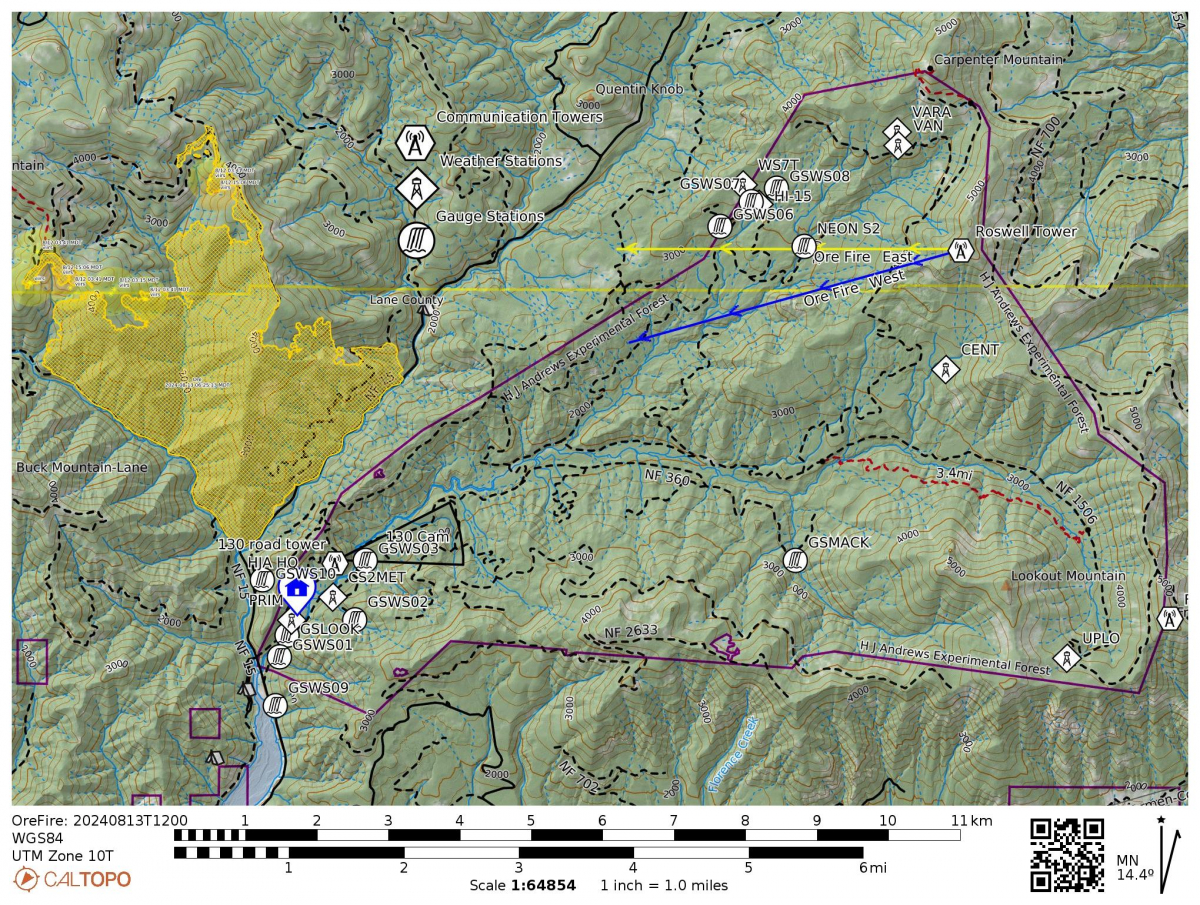
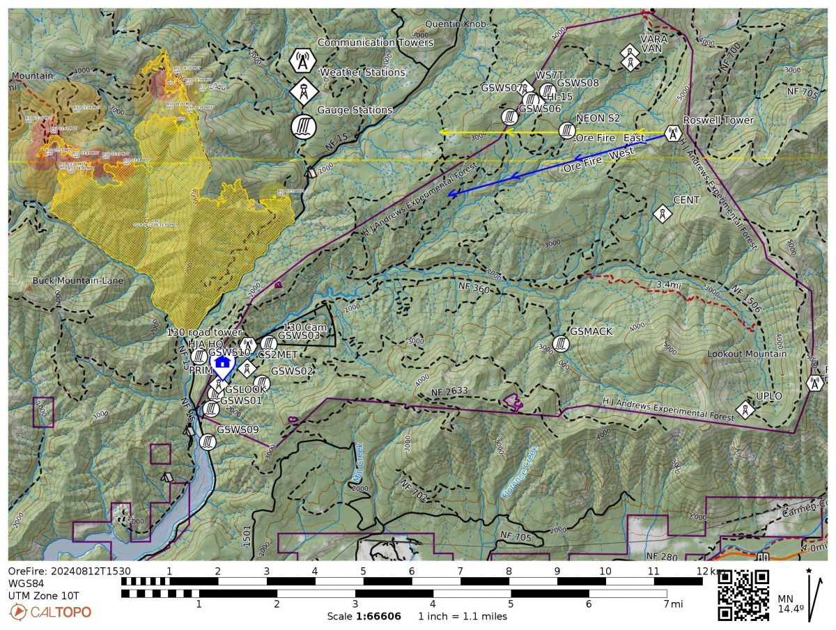
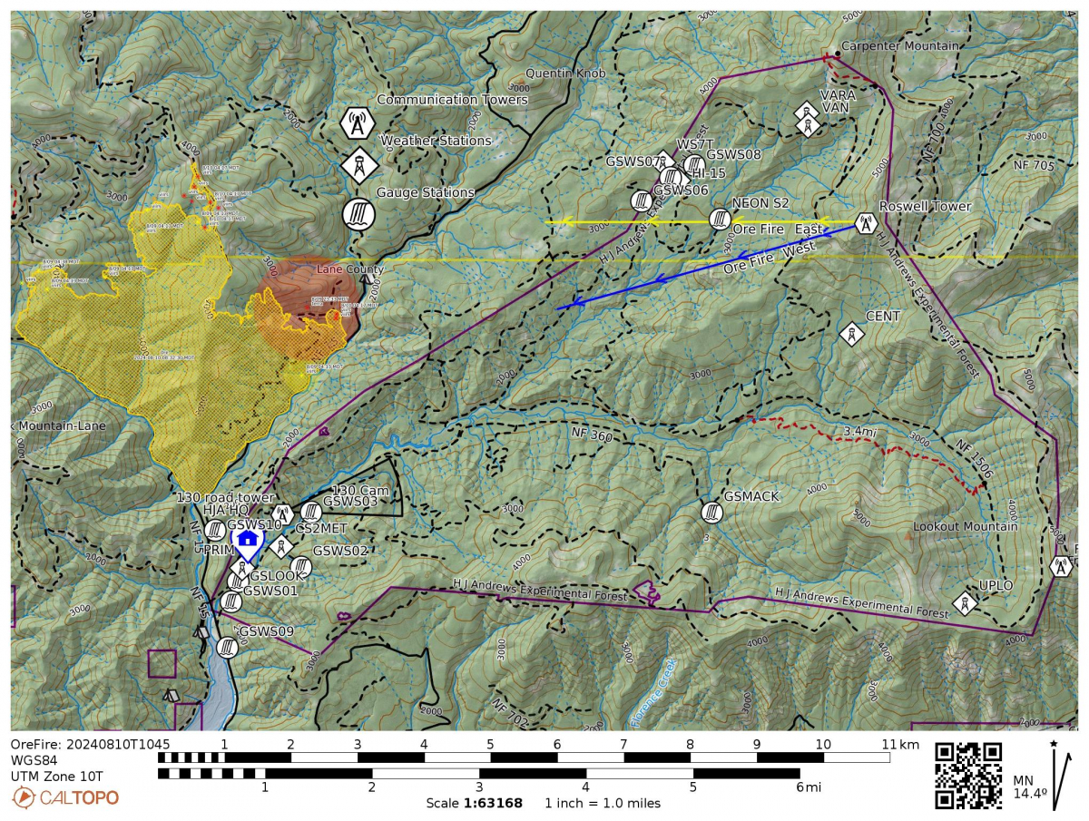
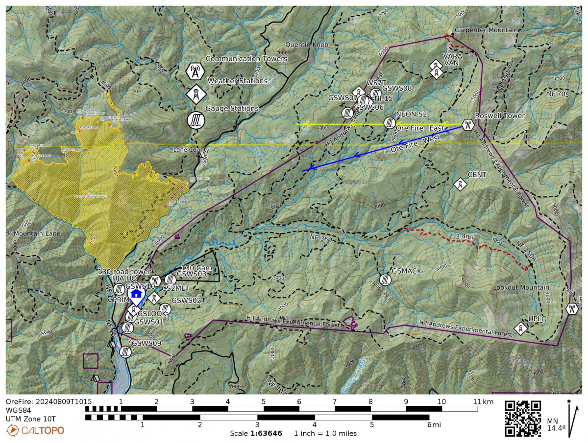
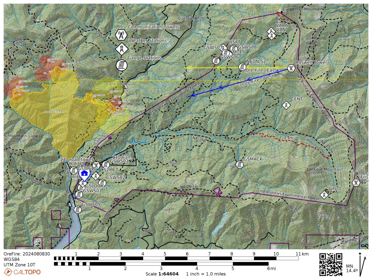
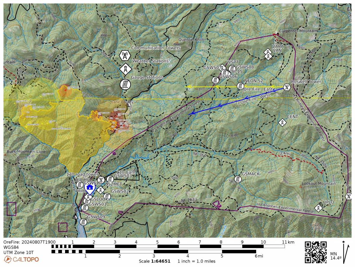
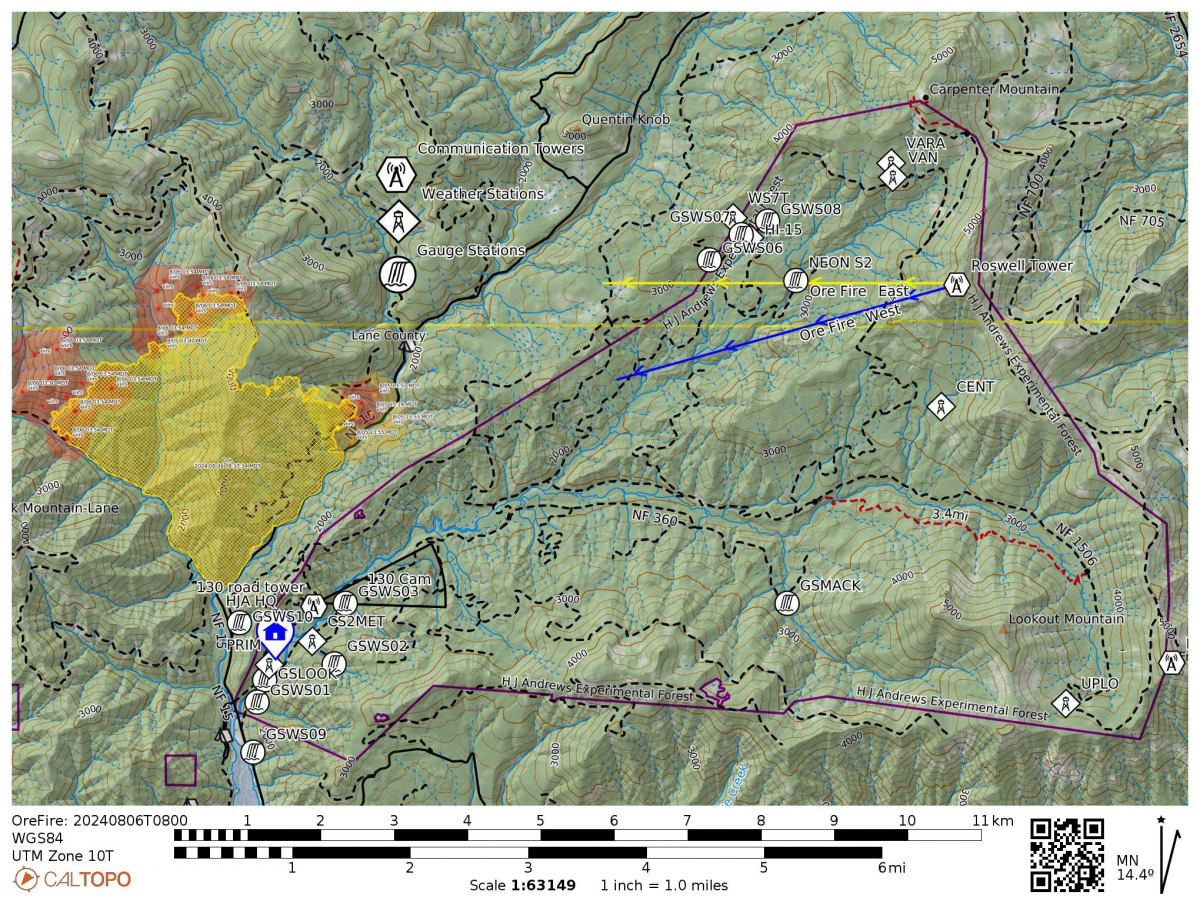
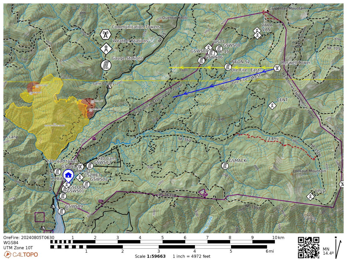
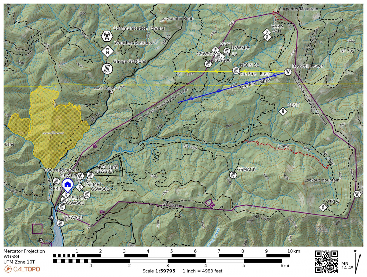
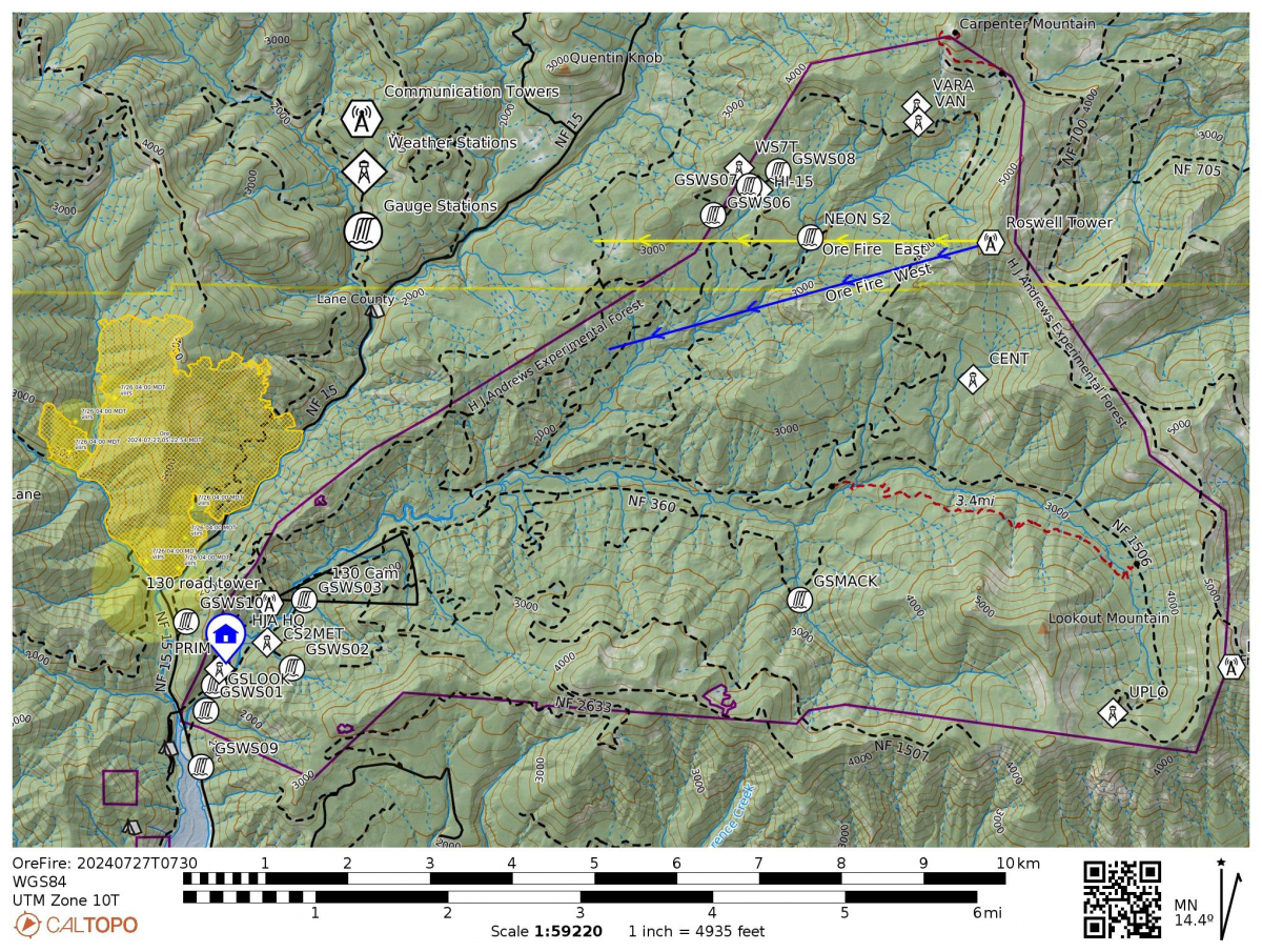
Check out the webcams, which, as of this afternoon, are showing clear views of the fire. The positions and view cones of the cameras are in the map, below.
July 30
Today’s Inciweb report lists the fire at 1,452 acres and 29% contained. Total Assigned Personnel: 310 | 6 engines | 5 hand crews | 3 dozers | 19 water tenders | 8 masticators | 4 feller bunchers. “Crews' arduous work over the past two weeks has resulted in containment lines that are protecting these values to the south…Yesterday, fire activity was moderated by scattered showers. Crews removed hazardous trees from the FS 1509 Road using explosives rather than felling these large diameter fire-damaged trees, minimizing exposure to ground personnel. Elsewhere to the north, heavy equipment operators graded, cleared and widened roads to be utilized as containment lines. Today, efforts are ongoing to patrol and monitor the secured fire perimeters. Plumbing with sprinklers and hose lays will be reallocated from the contained areas to the areas where the fire's edge is progressing down the hillside along the FS 1509 Road. Crews will begin connecting the FS 1509 Road north to the FS 842 Road utilizing a mix of hand lines and dozer lines to cut out a dangerous section of steep, tight turns…Hot and dry conditions return tomorrow and continue into the weekend, resulting in increased fire danger.” At this point, the fire is not burning within the H.J. Andrews Experimental Forest.
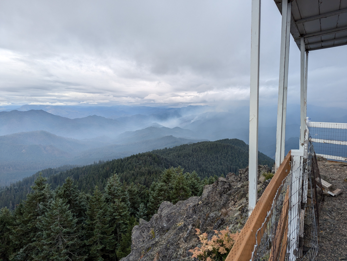
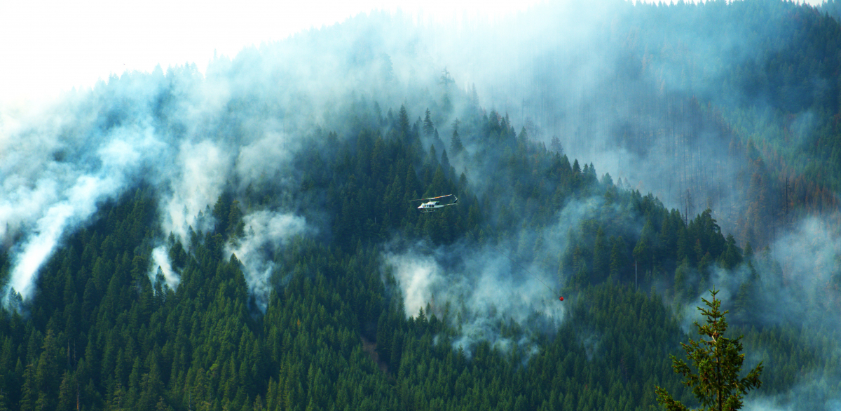
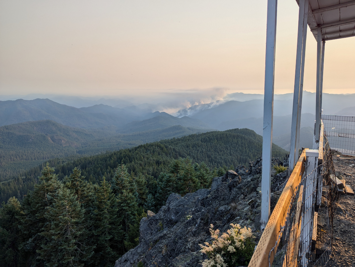
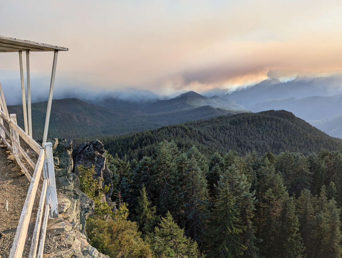
Fire Lookout Rob Mutch shared this photo of the fire from last night, July 29, as clouds moved over the region.
July 29
The Ore Fire Infomation Facebook page features images and information from the H.J. Andrews Experimental Forest today:
Today’s Inciweb report lists the fire at 1,452 acres and 29% contained. Total Assigned Personnel: 329 | 6 engines | 5 hand crews | 3 dozers | 20 water tenders | 7 masticators | 4 feller bunchers. “Yesterday, crews increased containment along the FS 15 and 1509 Roads with the assistance of favorable weather conditions and minimal fire activity. Specialized felling modules above Ore Creek on the FS 1509 Road removed hazardous trees, while chippers followed closely behind to reduce larger woody debris into finer material...Today, firefighters will use explosives to remove fire-damaged trees in the southwest corner that have hindered progress on the incident. Due to the trees’ size and condition, these hazards cannot be safely removed by fallers. Fire managers continue to evaluate areas where containment lines can be constructed to stop fire spread to the north…Cooler temperatures, higher humidity, and spotty showers are expected today, with the potential for rain this afternoon into tomorrow. A period of warmer-than-average temperatures and lower humidities will return Wednesday and continue into the weekend.”
July 27
The fire is reported at 1,307 acres and 4% contained. There was a spot fire that crossed the 15 road and river, closer to the research forest. Thanks to ground crews and aerial resources that spot fire was put out and is now in mop up and monitor status. The division near the Andrews is continuing with prepping the 15 road with hoses and cutting, and they're working on a line towards the north with a goal of minimizing the spread of the fire northwards. The opps team added a new division to work the west side of the fire to improve the 1509 road containment line. Supplies for structure protection at our headquarters were delivered this morning and are staged for rapid deployment should they become necessary. We remain grateful for the hard work and excellent communications with the fire operations team.
July 26
Inciweb reports the fire at 1,223 acres and 3% contained. The the containment falls along the 15 road, which threads between the fire and the HJA. To date, the fire has not encroached into the research forest. "Yesterday, the line was tested by the burning debris and logs rolling onto FS 1509 Road near Ore Creek. Heavy equipment operators cleared these roadways, allowing crews to quickly resume their work. Firefighters installed pumps, hose lays and sprinklers to pre-treat the unburned side of the road, raising the overall humidity and resulting in fuels being less receptive to fire. Today, firefighters are extending plumbing along FS 1509 Road northwest of Ore Creek. Dozers are being utilized to connect the FS 15 Road to the FS 501 Road. Vegetation removal will begin north of the fire on FS Road 1513, and crews will chip the woody debris into finer, more manageable material, returning it to the forest floor."
The fire information page today also shares, "The H.J. Andrews Experimental Forest near Blue River is one of the significant values at risk identified by the Willamette National Forest. This area holds important cultural and scientific value, as it has been the site of long-term research on climate, streamflow, water quality, vegetation succession, biogeochemical cycling, and the effects of forest management for almost 70 years. Firefighters are holding the fire north of FS 15 Road to protect this forest, its timeless resources and other values at risk from the Ore Fire." We remain grateful to fire crews for working so hard to protect the research forest!
This morning our research community met to discuss the impact of the Ore Fire. Due to the closure of the area, researchers will not be allowed into the research forest for the foreseeable future. The evacuation of the site, in mid-July, came at the peak of our busy summer research season. We’ve been scrambling to find housing for crews who had been staying on site — faculty, undergraduate students, graduate students, K12 teachers, writers, artists — and who were in the middle of their work. Research projects, workshops, and classes are being cancelled, retooled, or relocated. This disruption follows on the heels of the 2023 site closure for the Lookout Fire and the 2021 covid closures, causing additional challenges to graduate students and research projects. We’re seeking support for our students, especially. If you’d like to help, please contact the LTER Coordinator or donate online.
July 25
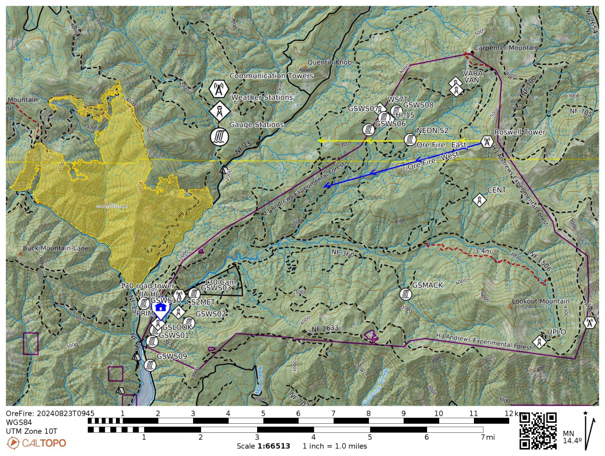
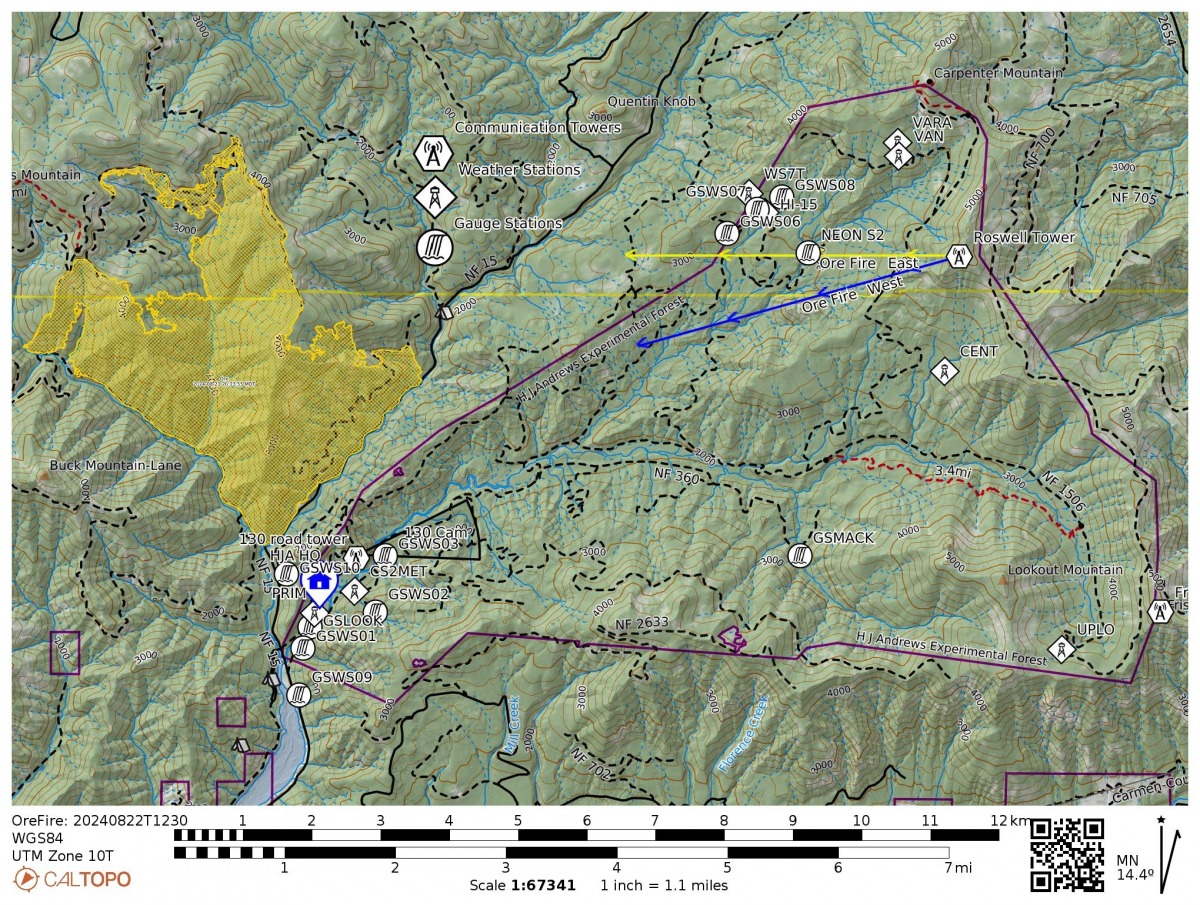
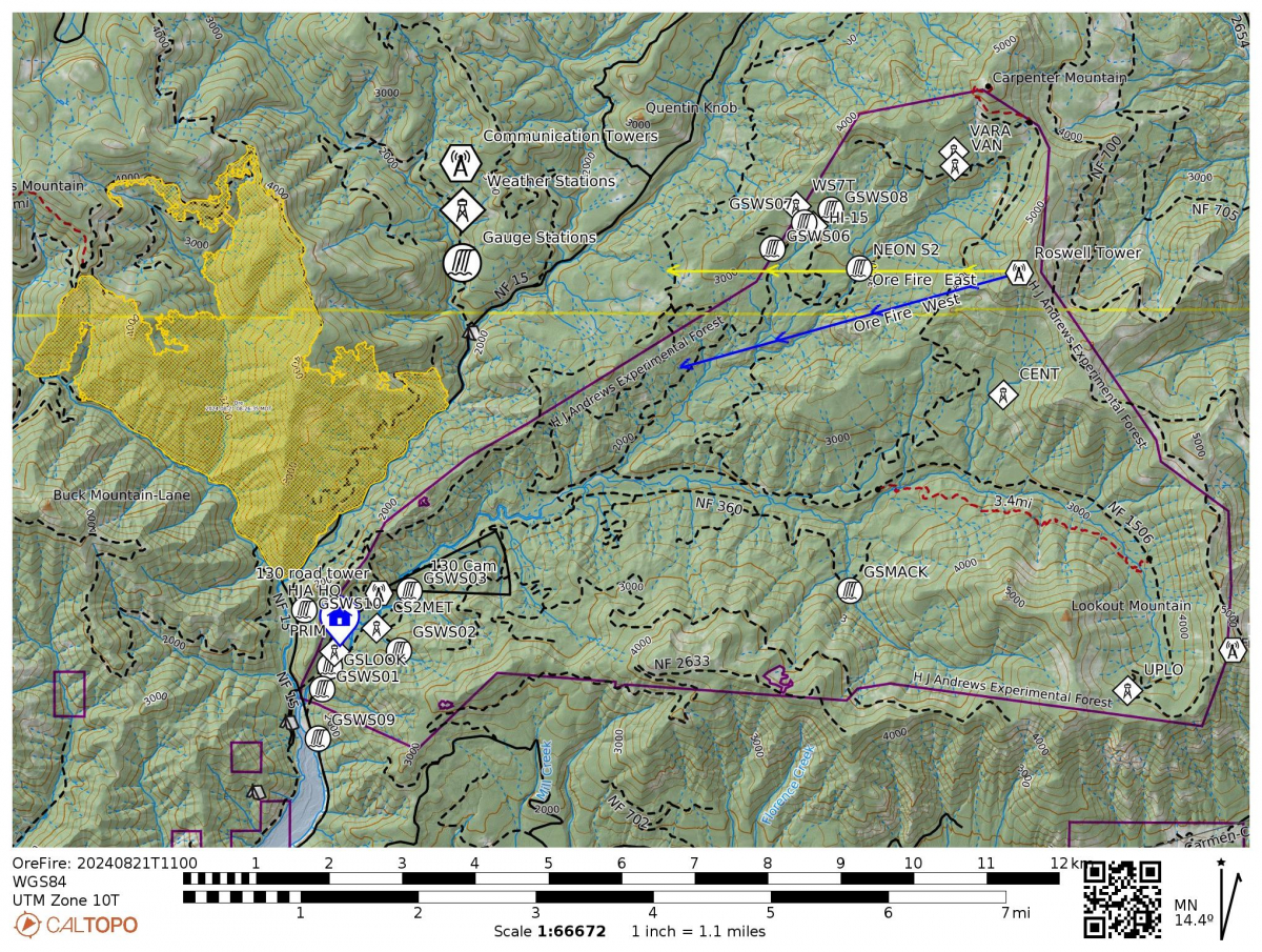
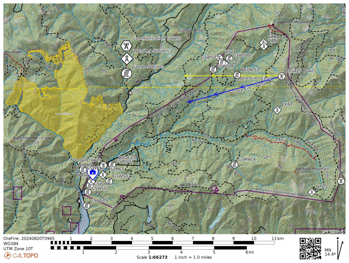
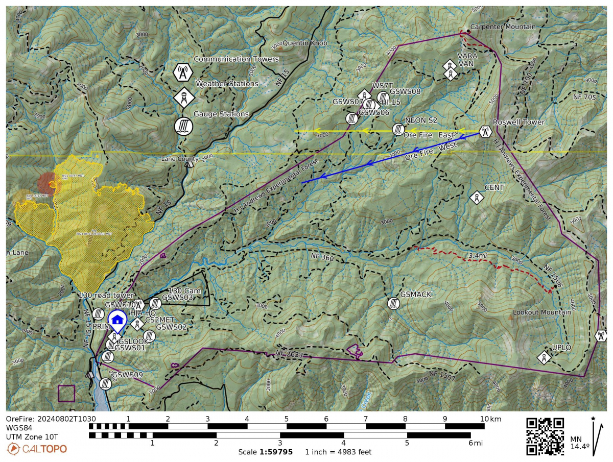
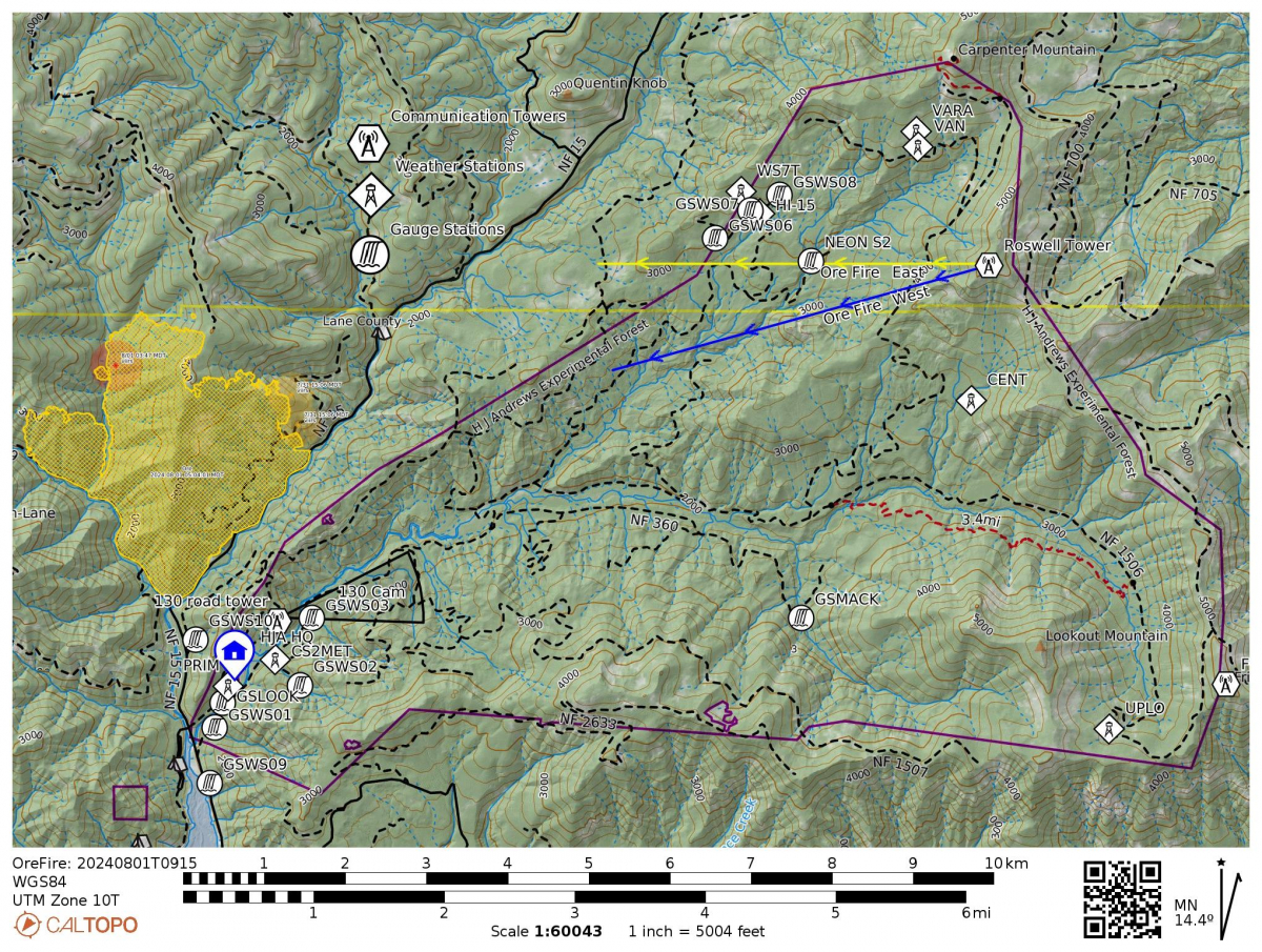
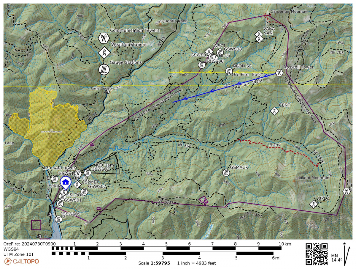
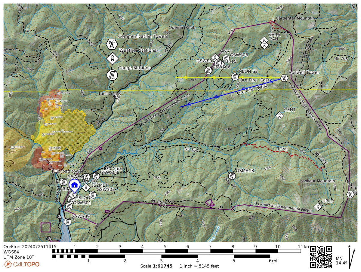
Today the fire is reported at 1,050 acres and 2% contained. Fire crews continue to fortify the 15 and 1509 roads as fire containment lines. The fire incident command team requested that we realign and refocus two of our webcams on the top of Roswell Ridge to face the Ore Fire. The webcams, now called Ore Fire West and Ore Fire East, can be seen on our webcams page. The map, below, shows the location of the webcams and their view directions. Big thanks to Mark Schulze, HJA Forest Director, for getting to the top of the Roswell Ridge tower and realigning the cameras, and to Adam Kennedy for creating the map and maintaining the webcams page.
Rob Mutch, an ecosytem photographer, and the official fire lookout posted at the tower on Carpenter Mountain, shared this photo of the Ore Fire late in the day yesterday, July 24.
July 24
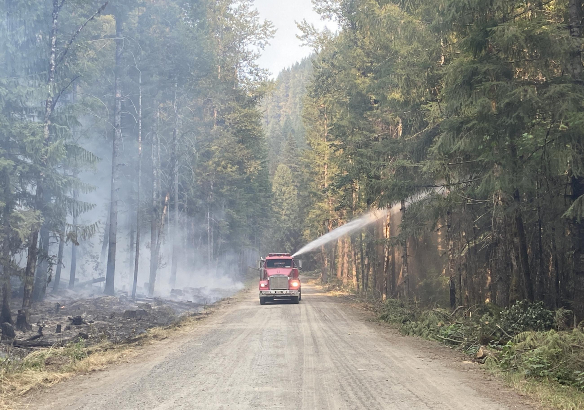
Inciweb reports the fire at 860 acres, 0% contained, and 301 total assigned personnel working on the fire. So far, fire crews have held the fire at the 15 Road, effectively protecting the HJA. From Inciweb: "Yesterday, burning debris rolling down the steep slopes caused fire to slopover (cross) the control line at the FS 1509 Road about a mile from the FS 15 Road junction. Ground crews, assisted by aviation resources, secured this slopover, but falling debris will remain a challenge in the southwest portion where the fire is most active. An engine patrolled and monitored through the night. Road grading was completed along the FS 1509 Road, north of Tidbits Trailhead. Firefighters successfully held the fire at the FS 15 Road, and heat is diminishing along the established control line. Today, crews will monitor the slopover, and patrol the rest of the southwest line as the fire continues backing down to FS 1509. Feller bunchers and masticators will follow the road grading operations above Tidbits Trailhead to strengthen the FS 1509 Road. Northeast of the fire, grading operations will begin along the FS 1513 Road."
July 23
Inciweb reports the fire at 747 acres: "Yesterday, cooler temperatures moderated fire behavior with growth mostly isolated to the southwest portion of the fire. Fire backed down the hillside and was held by ground crews at the FS 15 Road, where falling debris remained a hazard. The section of the FS 1509 Road to the Tidbits Trailhead was graded, and a feller-buncher removed fuels from the road to widen the containment lines. Handlines and hose lays have been set up from the FS 15 Road to the 500 Spur, with the equipment ready to be used if fire activity increases. Today, in coordination with Resource Advisors who have extensive local knowledge, fire managers are evaluating areas along the FS 15 Road where additional bulldozer lines could be established to safely and effectively stop fire spread. Crews and equipment have been strategically placed in areas where the fire poses the greatest threat to values at risk. As more resources arrive, fire line construction to the north will commence.
The H.J. Andrews Experimental Forest remains closed to researchers and visitors. We're collecting information from researchers and students who had ongoing research projects that were interrupted unexpectedly by the evacuation.
July 22
Inciweb reports the fire at 645 acres. Firefighters have been working hard to prevent the fire from crossing over the FS 15 Road. "With the help of aviation resources dropping water to moderate fire behavior, the fire slowly backed down the hillside above the prepared FS 15 Road, where it was met and held by firefighters on the ground. Crews and heavy equipment continued strengthening additional control features by widening roads and removing vegetation along the FS 15, 1509, and 1513 Roads. Today, crews are scouting additional sites where they can safely build control lines to stop the fire from spreading or threatening protected values. Firefighters are working with subject matter experts called Resource Advisors to identify and protect natural and cultural resources such as road integrity and old-growth timber. On the southwest edge where fire behavior is most active, hose lays are being installed near Ore Creek and along the FS 15 Road."
July 21
Inciweb reports the fire at 534 acres and 0% contained. Despite gusty winds and lightning last night, the fire did not cross the 15 road, thereby maintaining a line between the fire and the headquarters of the HJ Andrews Experimental Forest. From Inciweb's report: "Yesterday, firefighters removed hazardous trees along the FS 15 road and the fire’s edge. Aerial resources were active, supporting ground crews by monitoring fire progression and assisting with water drops. Heavy machinery, such as masticators and feller bunchers, removed and chipped large trees and vegetation into more manageable material along the FS roads 15, 1509, and 1503. Firefighting efforts were successful in holding the fire north of the FS 15 Road. In addition, crews continued to scout divisions and identify possible control lines utilizing natural barriers and access features....Today, crews and equipment will build on progress made by continuing work on FS roads 15 and 1509 by thinning and removing fuel from these containment lines. Air operation resources are available and will be utilized to assist personnel as needed and monitor fire progression. Firefighters are also working closely with Resource Advisors to minimize damage to the landscape and cultural resources."
July 20
Northwest Critical Incident Management Team 10 (NWT10) took command of the fire at 7 PM last night, with additional resources expected in the coming days. The new Ore Fire InciWeb page has official information on the fire. It reports, "Fire suppression efforts continue on the Ore Fire, which is burning in steep, rugged terrain 7 miles northeast of Blue River, Oregon. The current acreage of 500 is an estimate due to the unavailability of an updated infrared flight...Yesterday, fire activity increased in the afternoon, prompting the withdrawal of resources along the fire line due to safety concerns. The rugged terrain poses significant challenges and hazards to firefighters, inhibiting their efforts to attack the fire directly...Given the hazardous terrain, fire managers are implementing indirect containment strategies, such as utilizing existing roads to create containment lines instead of deploying firefighters directly on the fire's edge...Today, crews and machinery will work to prepare FS Road 15 and 1509 by thinning vegetation, removing fuel and improving these features as containment/contingency lines. Air operation resources are available and will be utilized to assist personnel and monitor fire progression...Hot and dry conditions will continue through the weekend. This afternoon, unstable air conditions and a chance of thunderstorms in the area are possible, which may lead to increased fire activity. Cooler temperatures in the 80s are expected early next week."
Real-time weather data
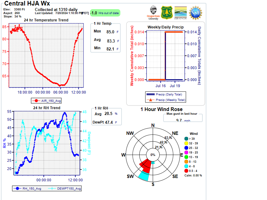
The H.J. Andrews Experimental Forest is networked with sensors that continually record and transmit data through our radio telemetry system. The long-term monitoring system measures key weather conditions—such as temperature, precipitation, wind direction and wind speed—and stream conditions—such as water temperature and stream flow rates. These data, which have been collected for decades, are integral to our long-term research program.
To assist firefighters working on the Ore Fire, we have created a special Current Weather Summary page, designed to meet the needs of firefighters. Wildland firefighters pay attention to the weather carefully; weather determines where they try to corral a fire and where they put themselves in its path. Wind is critical in pushing a fire forward, and fuel moisture, largely a product of temperature and humidity, is key in how easy it is to light the vegetation on fire. The new Current Weather Summary page gives a snapshot of key weather conditions across H.J. Andrews Experimental Forest as frequently as possible to give firefighters the data they need to make decisions and stay safe. (Big thanks to Greg Cohn and Adam Kennedy for their work on the climate measurements program, radio transmissions, and real-time streaming data pages.)
Photos from Rob Mutch, Fire Lookout on Carpenter Mountain
Rob Mutch, an ecosytem photographer, and the official fire lookout posted at the tower on Carpenter Mountain, has been watching and photographing the fire as it has been moving and growing. The photo from Rob, below, shows the HJ Andrews Experimental Forest watershed in the left half of the image, and the smoke rising from the Ore Fire at the center of the image. The photo was taken in the late afternoon of July 20. Rob will continue his official lookout duties unless the conditions of the fire cause him to be evacuated. (Thank you for your careful watch, Rob!)
July 19
The WatchDuty website reports the fire at 440 acres. Today small crews of researchers were allowed back on site for targeted retrieval of essential supplies, computers with data, and vehicles.
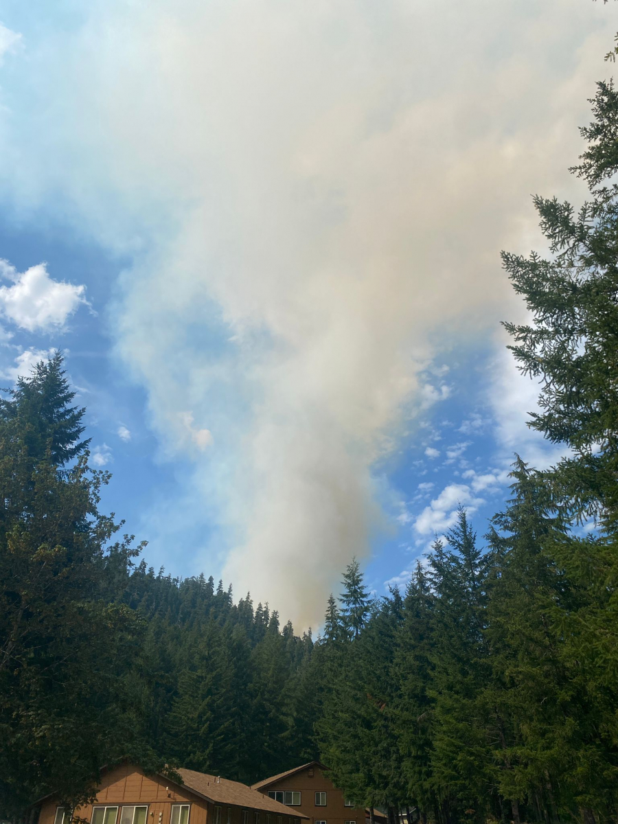
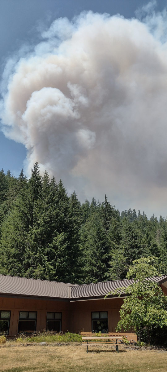
By late afternoon, the smoke plume from the fire had grown significantly and could be seen towering over the buildings at headquarters. The photo below shows the smoke plume above the cafeteria building.
July 18, 2024
Firefighters with the Willamette National Forest continue to work on containing the Ore Fire, which is reported at about 250 acres. A fire management team arrived today and will start tomorrow.
The Willamette National Forest issued an emergency closure order for the Ore Fire: "The closure order, which is for public and firefighter safety, is in effect through Nov. 15, 2024, unless rescinded or modified sooner." The closure impacts the area directly west of the 15 road. See the WNF closure map for more detail.
July 17, 2024
A fire management team has been called to the fire and will take over on Friday July 19, 2024. When that team comes on, they will have a communications person who will create a page on Inciweb with regular updates. In the meantime, the Willamette National Forest (WNF) has a crew on the fire. In addition, they are putting out other fires from lightning strikes in the area from last night.
Firefighters continue work to suppress the fire, now named the "Ore Fire." The fire is about 200-250 acres. Resources working the fire include 5 crews, 4 engines, 2 dozers, 2 feller-bunchers, 2 helicopters, and 2 water tenders. A resource order was submitted for additional crews, aviation assets, engines, and equipment.
The site is closed to researchers and visitors.
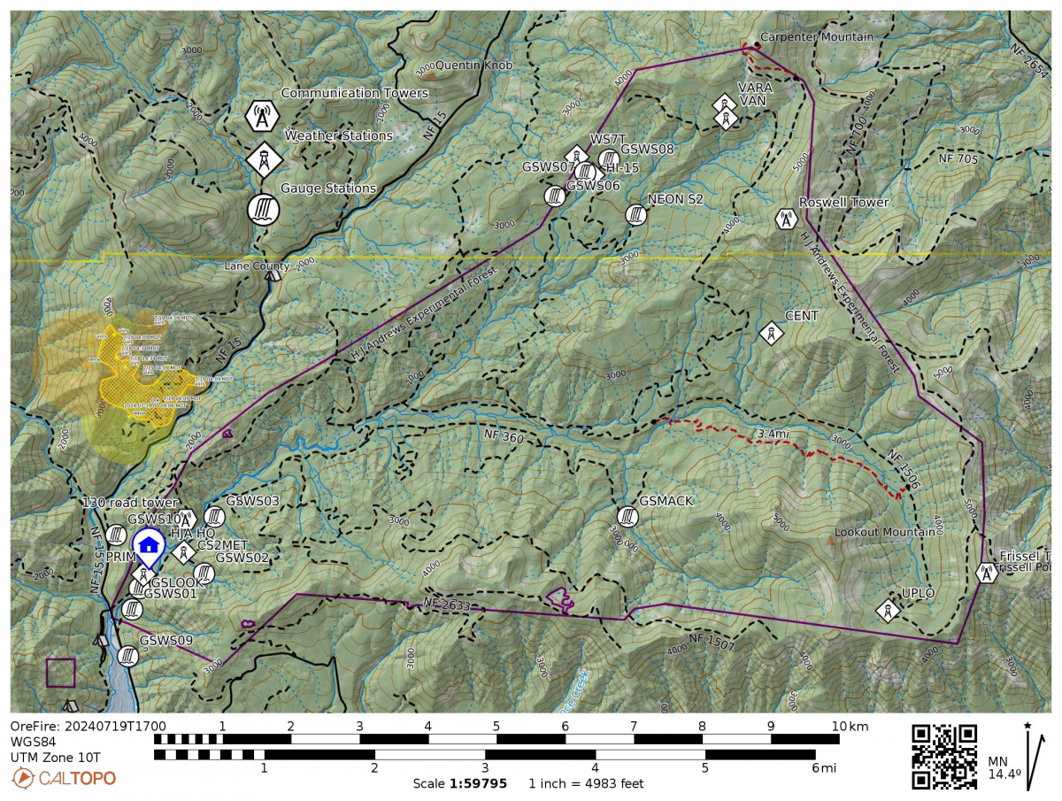
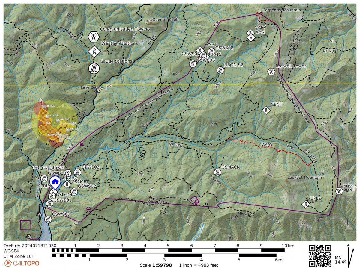
Maps
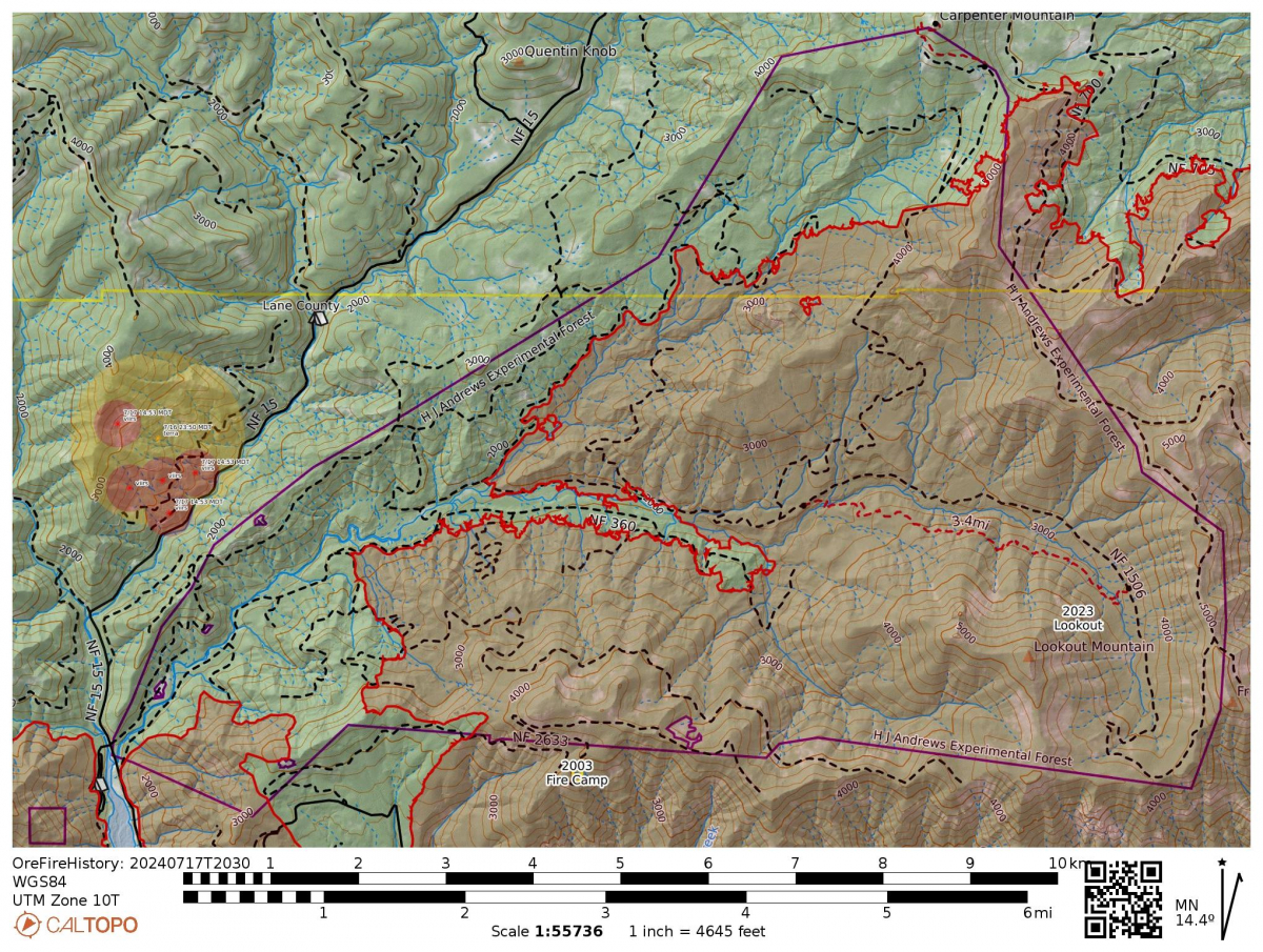
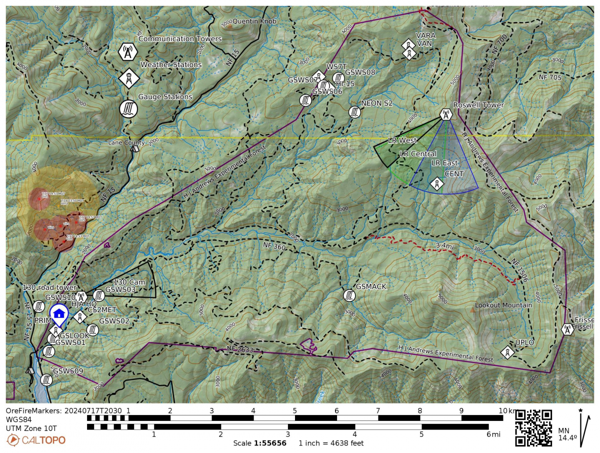
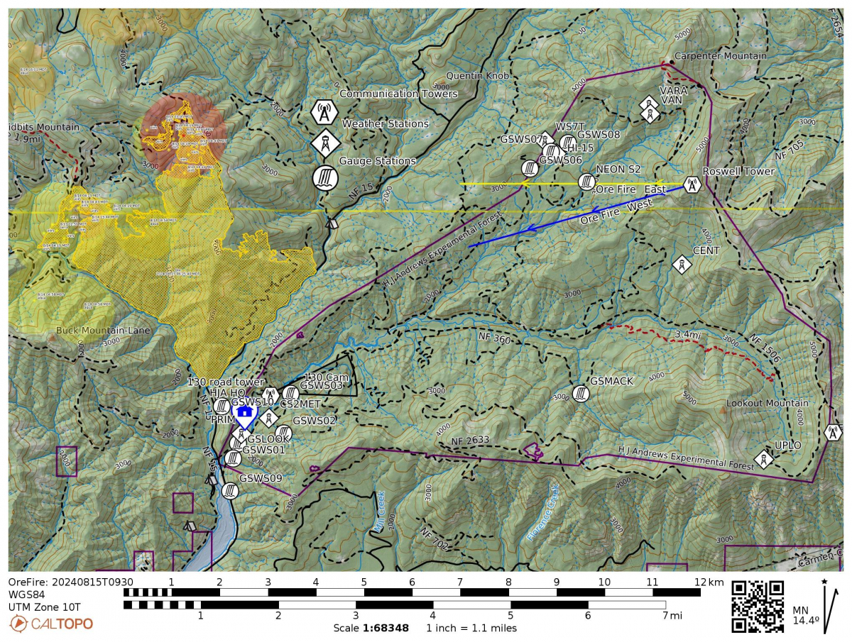
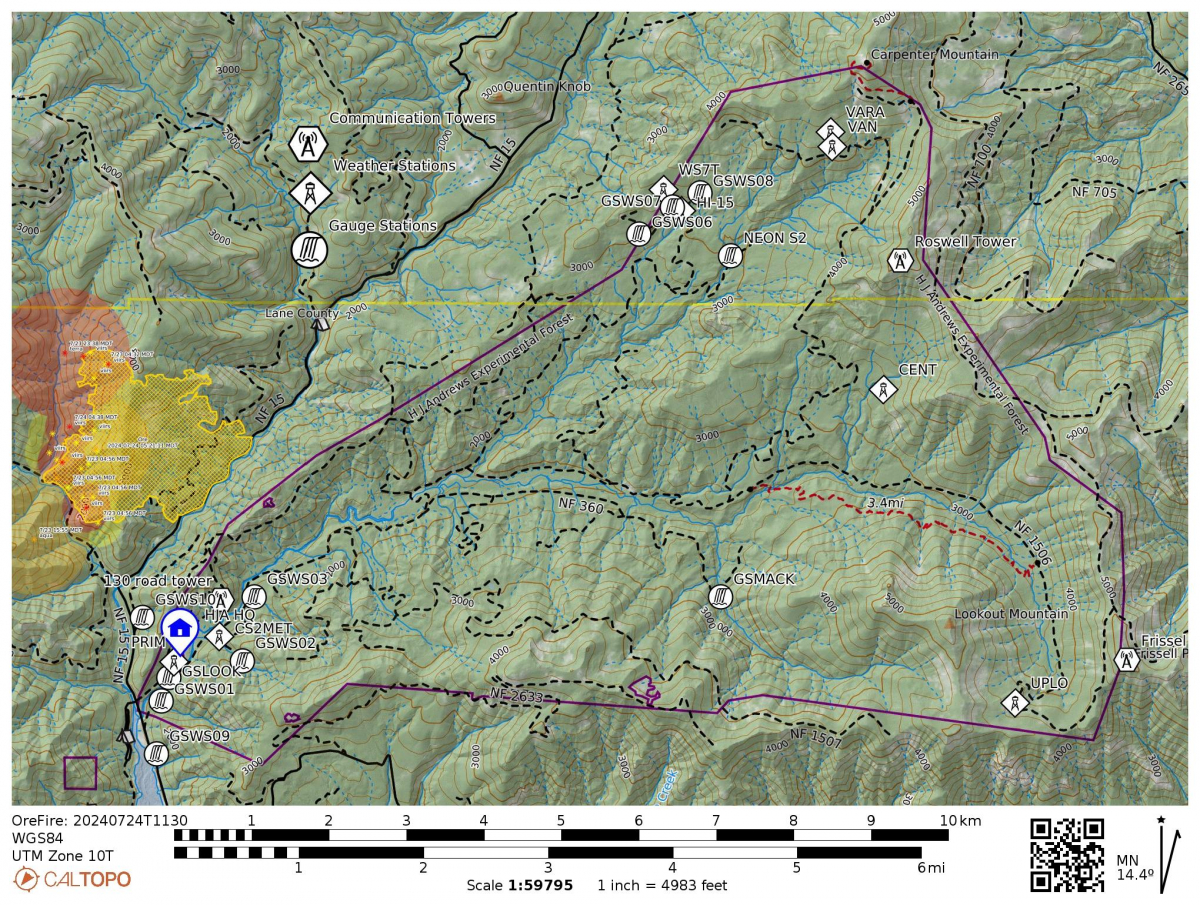
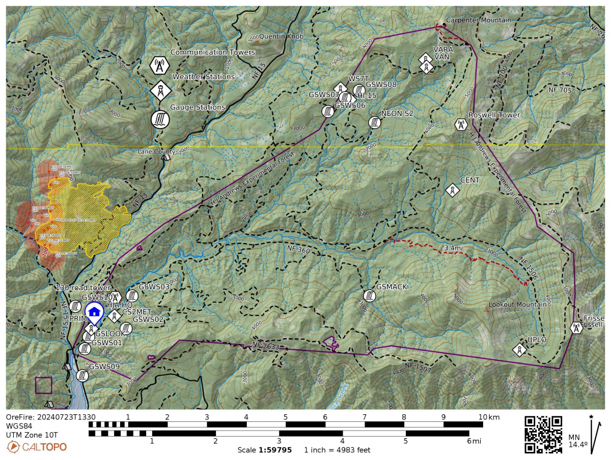
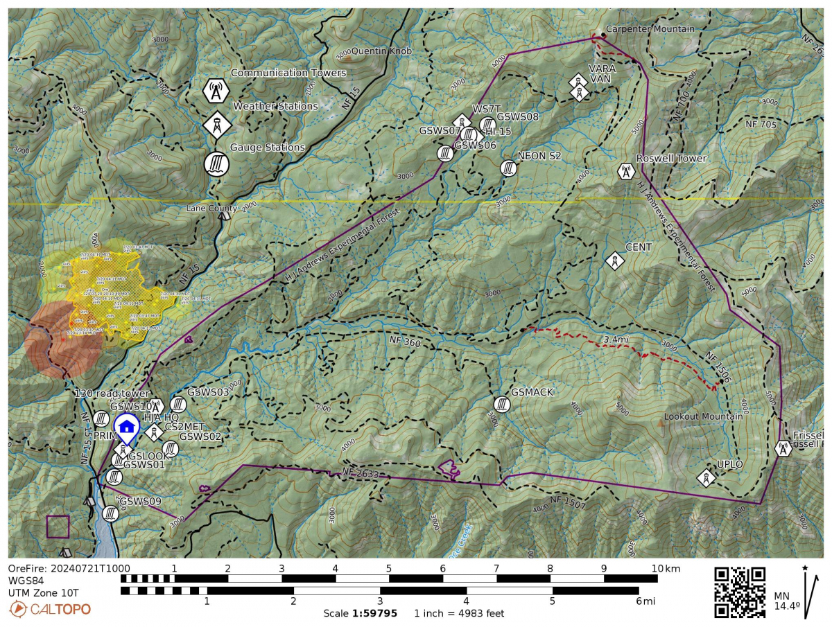
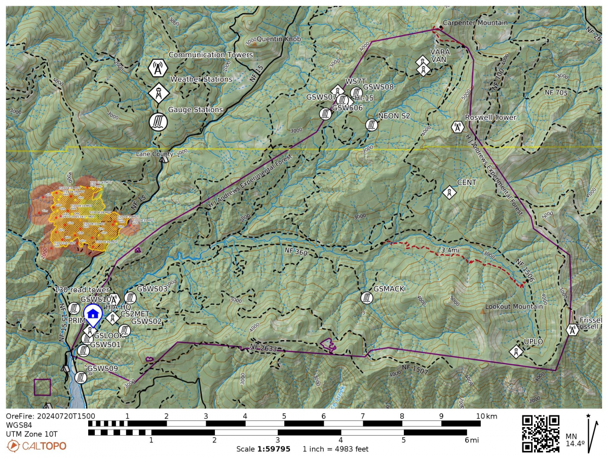
Red dots are most recent heat detections (less than 12 hours), then orange (12-24 hours), and finally yellow (24-48 hours). The dark purple line, in the rough shape of a sideways heart, is the boundary of the H.J. Andrews Experimental Forest. Symbols show the location of our headquarters facilities, the 130 tower and webcam (bottom left), and Roswell tower (top right), with projected cones of view for each of the webcams. The red area and outline shows what burned in the 2023 Lookout Fire.
July 16, 2024
As ashes and needles fall on the heads of people at HJA headquarters this afternoon, local evacuations are taking place in the area owing to the fire just north of HJA between the 502 and 505 roads. Currently the fire is moving north away from HJA, but it kicked up in the crowns this afternoon with 8-10 feet flame length. Additional resources have been called to the fire, including air and ground support. HJA Headquarters have been evacuated of all crew and staff. Everyone is safe.
