10/16/2020
 Final Update:
Now that the fall rains have arrived and the Holiday Farm fire is mostly contained, this is the final post to our Fire Updates page. Future new information will be shared via our News and Events.
The Holiday Farm fire ignited the night of September 7, 2020, south of the Andrews Forest. All personnel evacuated safely. We are grateful for the overwhelming support of our community in donating $12K, in only two days’ time, to support displaced Andrews Forest families. Some families were able to return home, while others lost their homes entirely. Our support and thoughts remain with our community and neighbors affected by the fire.
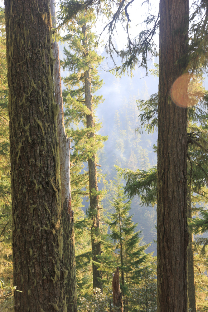
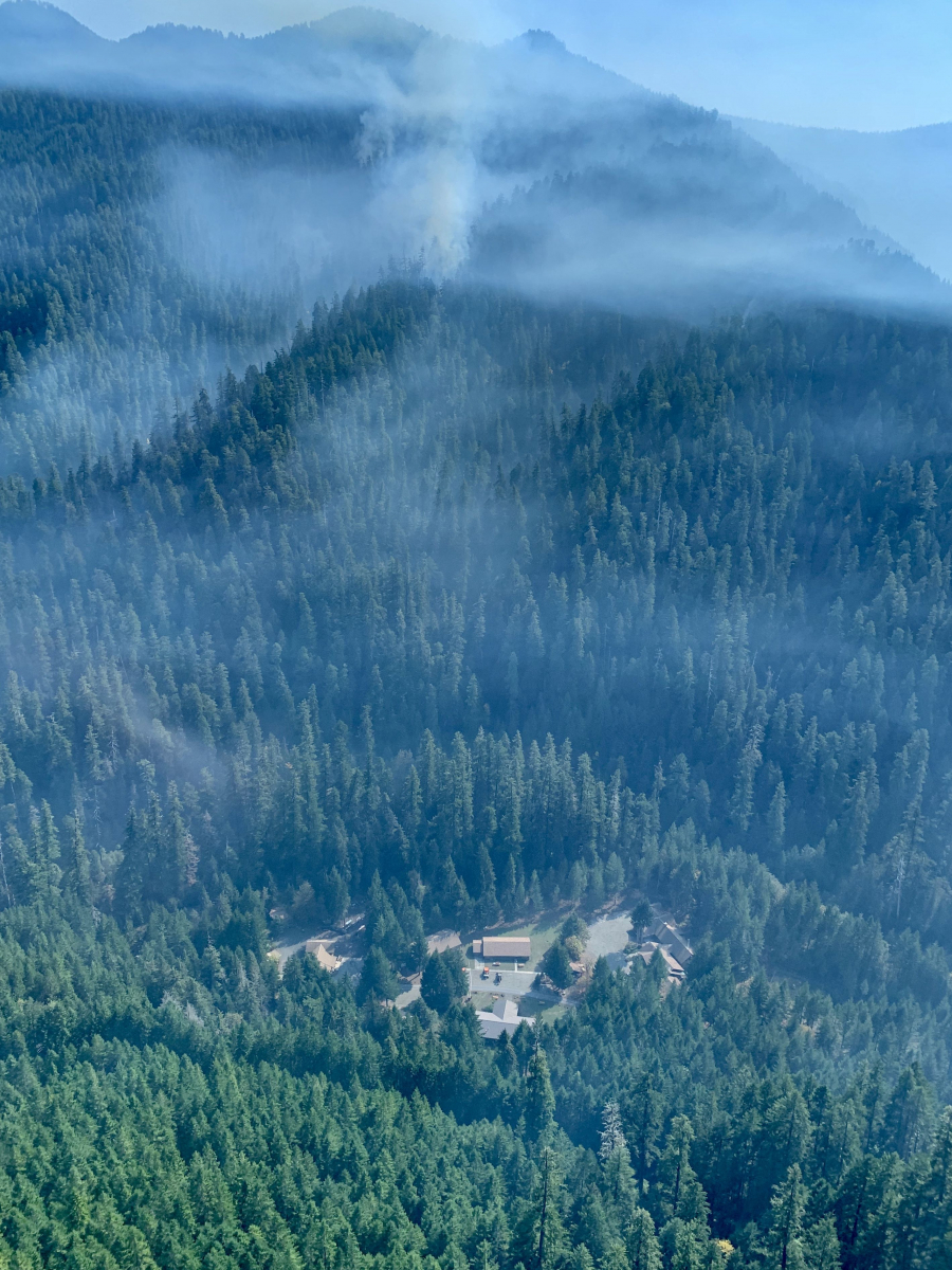
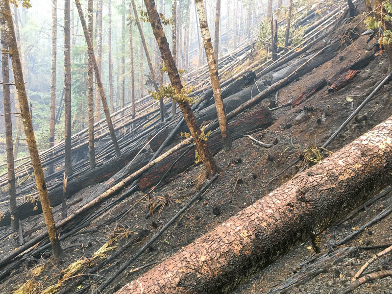
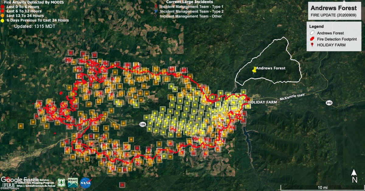
Fire entered the Andrews Forest on September 12, at the south boundary of Watershed 9, and progressed northward into Watershed 1, then Watershed 2. The fire burned mostly at low severity within the Andrews Forest, moving along the ground. We see small areas of canopy tree death in these watersheds, where fire continues to smolder in large snags, logs and roots, and could overwinter as embers to reignite next spring. Our headquarters facility was spared, and the stream gauging stations in the three burned watersheds suffered minor or no damage. Our gratitude goes out to the fire crews who worked diligently to save the research facility and to keep us informed of fire suppression activities on site.
Our attention turns now to assessing the damage from the fire and the fire suppression activities. Fire lines were dug by hand and by bulldozer in Watersheds 1 and 2, along the 1507 and 2633 roads, and around the headquarters. In some places the fire and fire lines impacted permanent vegetation plots that have been studied for 50 years, and through study plots for soil moisture, hydrology, plant phenology, and forest microclimate. Much of the cost of repairing research infrastructure will be the expense of extensive personnel time to relocate and resurvey the damaged areas and reinstall sensors.
As we have learned from our long-term work in the Andrews Forest, many unplanned disturbances happen over time; Watershed 1, for example, experienced extensive toppling of the young forest by heavy snow in the winter of 2019. With each event comes new opportunity to learn about this dynamic landscape. Researchers are working quickly to set up monitoring and studies that will help us learn from the fire, and we have decades of pre-fire data to use as the foundation for comparisons.
To support our work, and our recovery from the fire:
Links:
- News and Events: https://andrewsforest.oregonstate.edu/about/news-events
- Photos (see fire galleries): https://andrewsforest.oregonstate.edu/data/gallery
- Videos (see the Holiday Farm Fire playlist): https://www.youtube.com/channel/UCFd4IHt3s2nvFNz4NCDr-1g
- Andrews Forest Facebook: https://www.facebook.com/AndrewsForest/
- Holiday Farm Fire InciWeb report: https://inciweb.nwcg.gov/incident/7170/ (final update 10/12/2020)
- Holiday Farm Fire Facebook Page: https://www.facebook.com/HolidayFarmFire/ (final update 10/16/2020)
To be added to our email list for events and our newsletter, email the LTER Coordinator.
Access to the Forest:
Access to the Andrews Forest and the fire zone will not be possible before Spring 2021, except in cases of demonstrated urgent need. Research access must go through Mark Schulze or Sherri Johnson and necessary USFS permitting.
THANK YOU for joining us on this journey and for your support!
10/15/2020
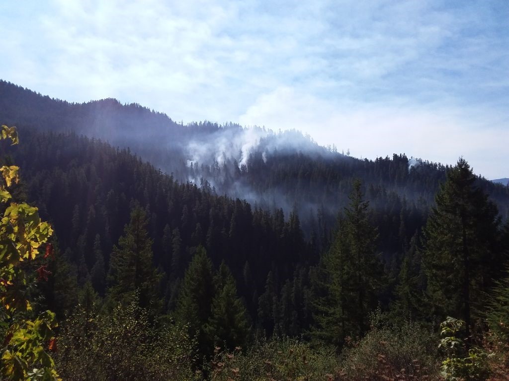
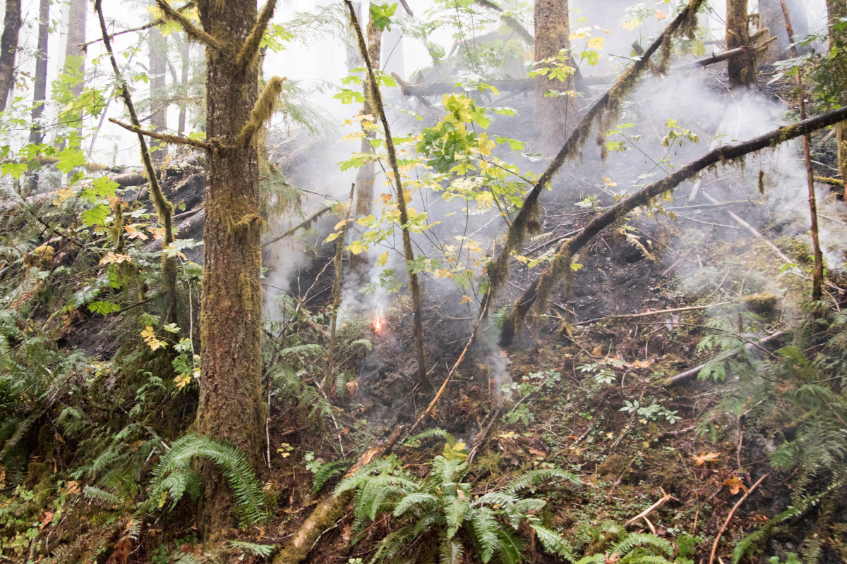
We've posted a new photo gallery of images that feature fire and fire suppression work in Watershed 2 and along the 1507 road on the Andrews Forest. Small areas of fire continue to smolder in the old-growth stand of Watershed 2, mostly within large snags and downed logs. If recent, nearby Terwilliger fires are a good refrence, we may see embers overwinter and reignite fire next spring.
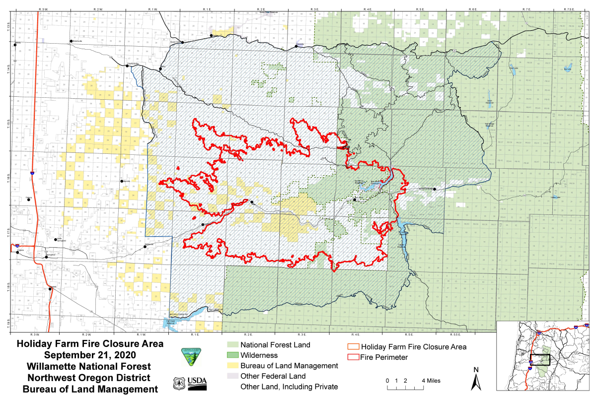
Large areas of the Willamette National Forest, including the entire Andrews Forest, remain closed. Access to the site and the fire zone will not be possible before Spring 2021, except in cases of demonstrated urgent need. Research access must go through Mark Schulze or Sherri Johnson and necessary USFS permitting.
10/14/2020
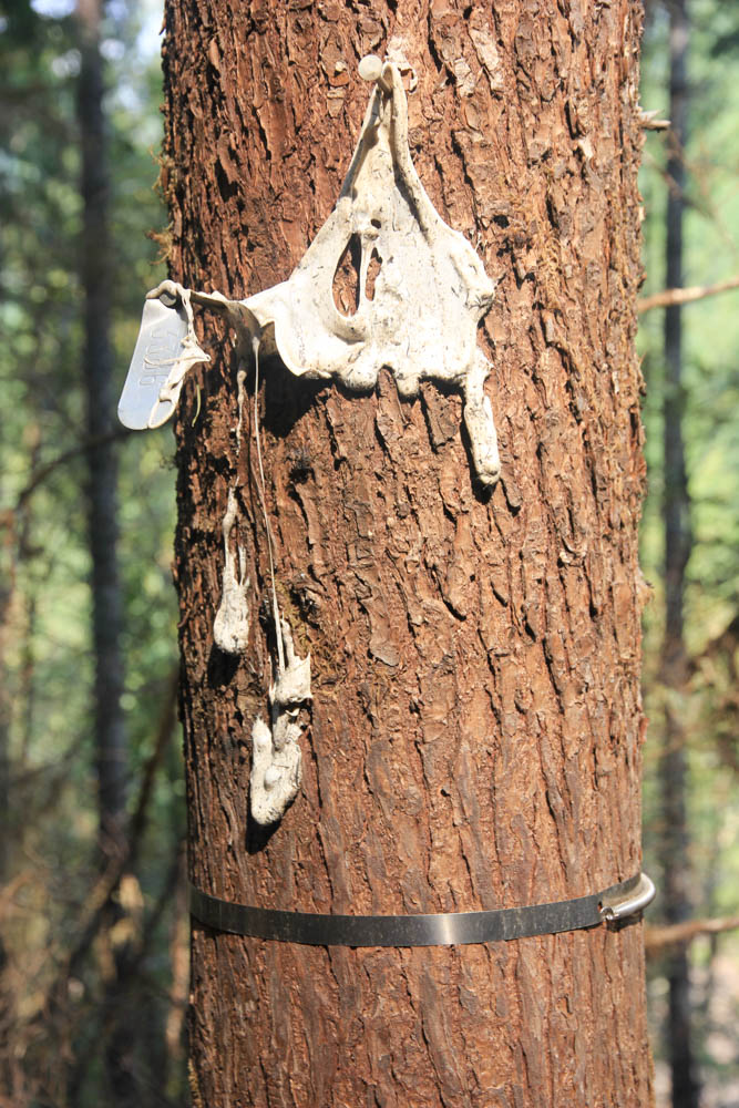
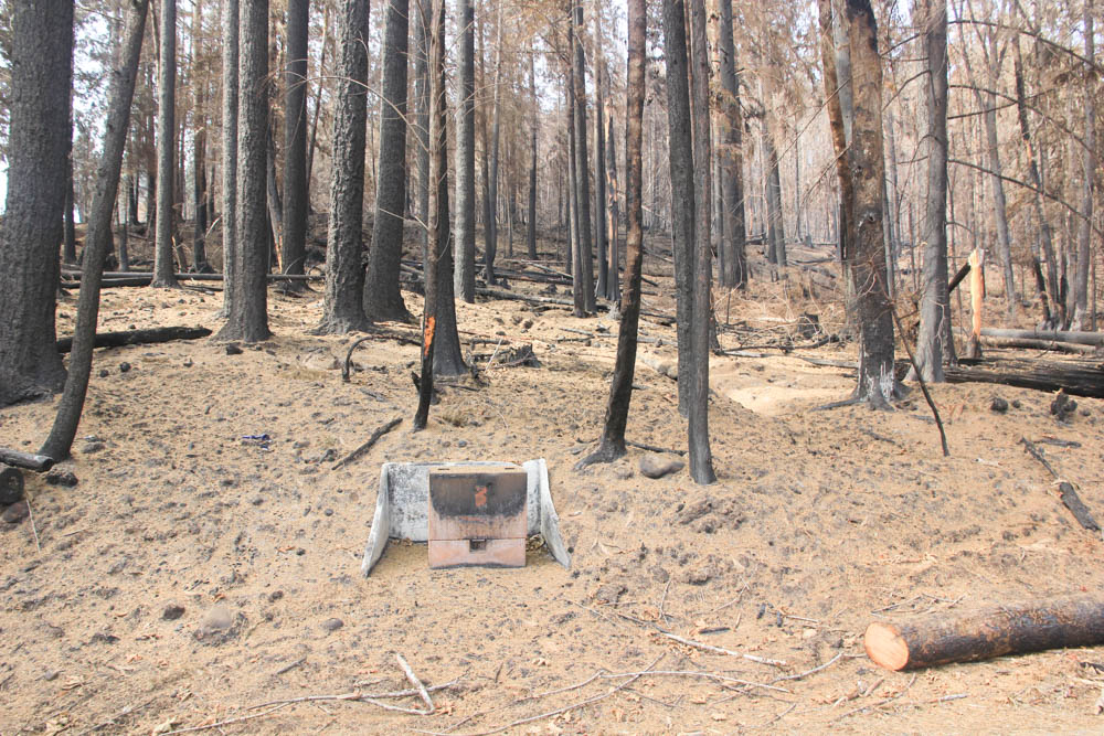
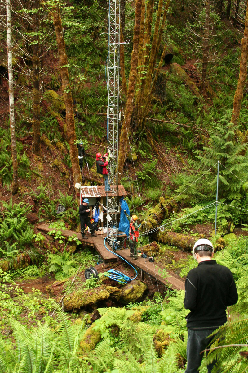
Researchers at the Andrews Forest are interested in how forest microclimate influence long-term bird population trends, and whether forest structure (e.g., complex old-growth versus simplified plantations) mediate forest microclimate, with beneficial consequences for climate-sensitive bird species. To get at this question, researchers deployed an extensive network of distributed temperature sensors at 184 stations across the entire Andrews Forest, including in areas that were burned by the recent fire. It turns out that forest structure has a very strong effect on the temperatures experienced by birds within and below the canopy (pub), with old growth being up to 2.5 degrees cooler during the bird breeding season. This climate moderation has consequences for bird distributions and movement (pub), as well as population trends (pub). Because the information on microclimate will be invaluable in studying changes after the fire, and how the birds will respond to the changes in the landscape, researchers will be replacing the numerous distributed temperature stations melted in the fire (see photo). Researchers will now be able to measure how post-fire conditions influence microclimate, but also how bird communities change following the disturbance.
10/13/2020
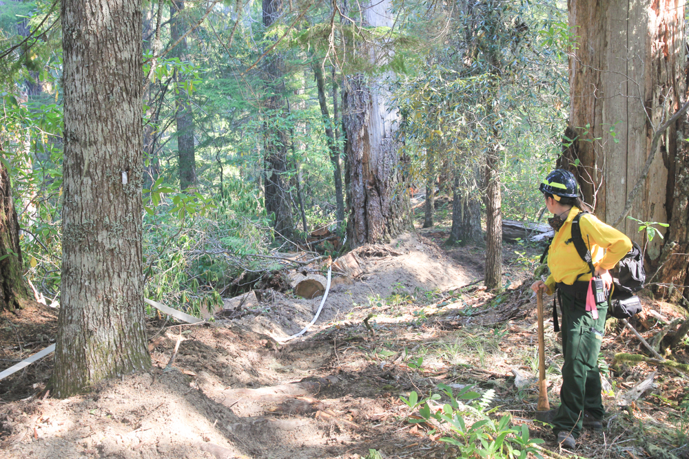
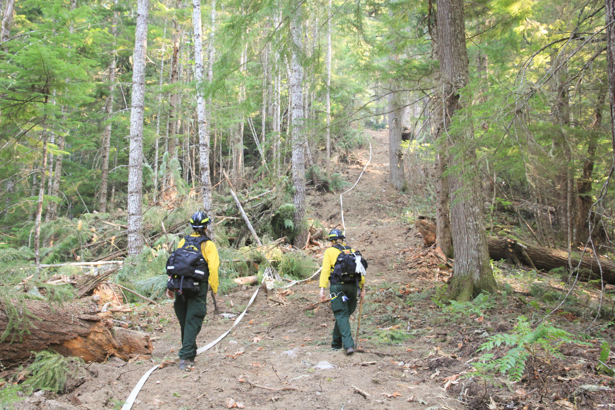
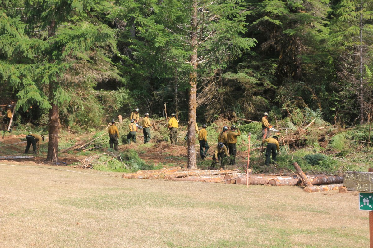
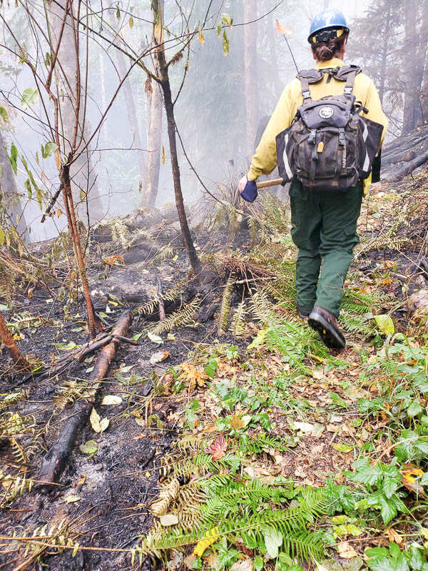
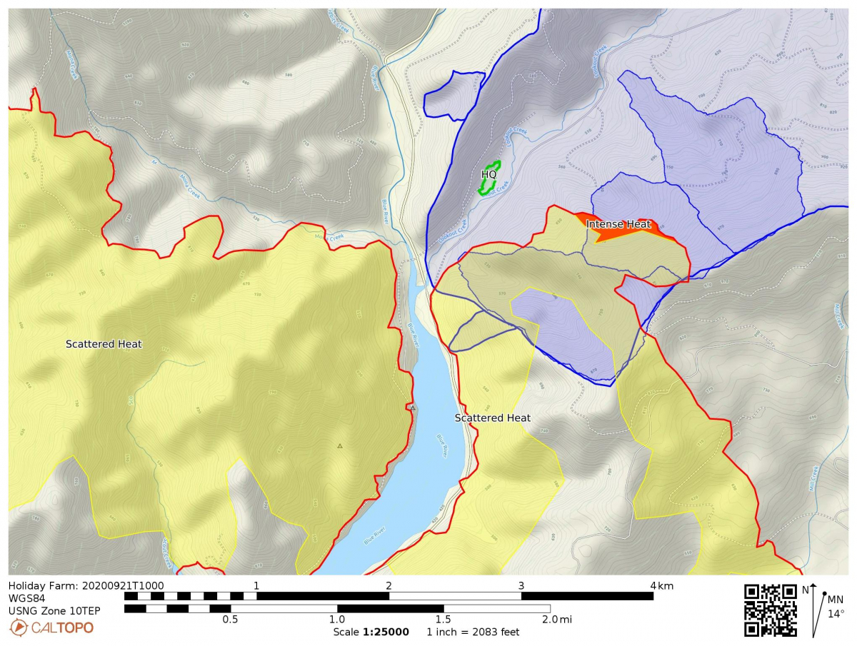
With the fire contained and fall rains returning, suppression repair and BAER (Burned Area Emergency Response) efforts are focused on controlling erosion and protecting water quality. Fire crews have been repairing bulldozer tracks along the contingency fire line on road 1507 and the primary line in WS2. Suppression efforts connected segments of the 1507 road with dozer tracks to create a relatively straight fuel break running from the 465 junction to the 1506 road. This line would have been the secondary line of defense if more direct containment lines in Watershed 2 had been unsuccessful.
This week an excavator replaced the soil and vegetation that had been removed from the fire line. The objective is to limit erosion and facilitate long-term recovery. A video of the suppression repair work is on our YouTube Holiday Farm Fire playlist.
10/12/2020
The Holiday Farm Fire is now at 96 percent containment. Steady rains fell over the weekend. The closest Remoted Automated Weather Station (RAWS) station recorded 3 inches of rain since Friday evening. The forecast for the week is for more rain and drizzle through Tuesday, when another ridge of high pressure builds off the coast, bringing a brief period of drying before additional precipitation is expected Friday and Saturday. On Tuesday, command of the incident will be transferred to the USFS McKenzie River Ranger District staff.
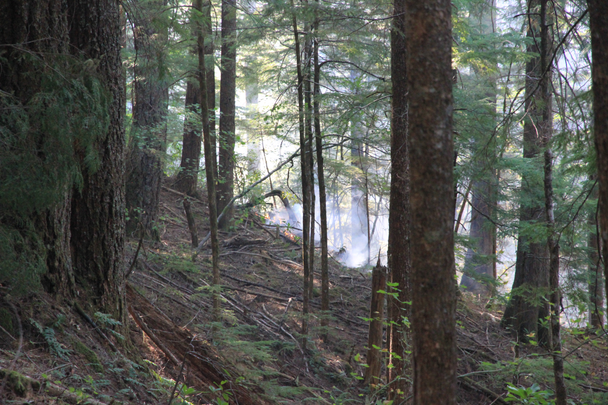
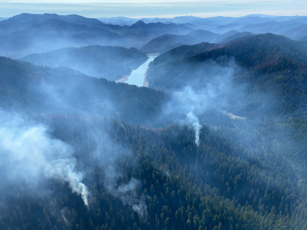
Work remains for fire suppression and restoration in Watershed 2 at the Andrews Forest, but due to the conditions and concerns for safety, firefighters will be working cautiously in the area. Even after the rain, areas within Watershed 2 continue to smolder.
10/9/2020
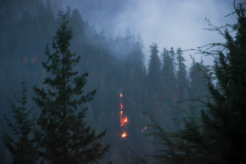
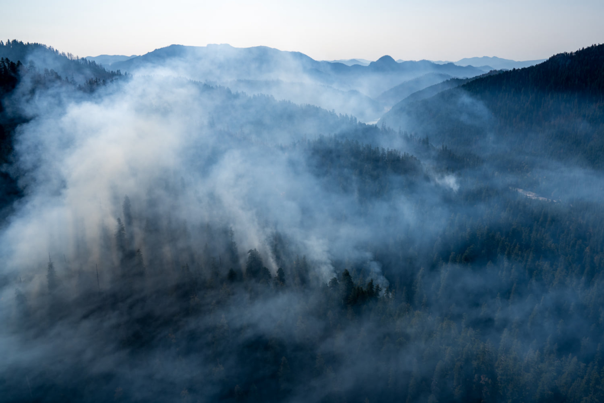
Smoke and ground fire persist in the old growth stand of Watershed 2.
The Holiday Farm Fire is 84% contained and remains at 173,393 acres. Rain is on the forecast, starting at midnight tonight.
10/8/2020
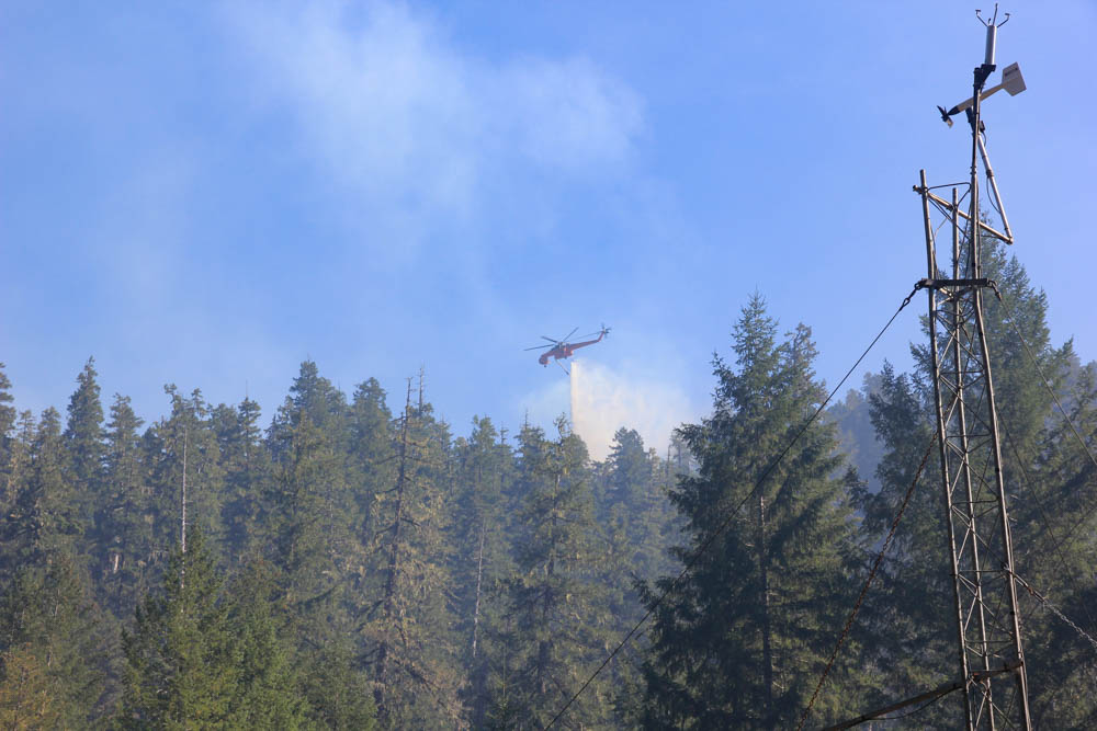
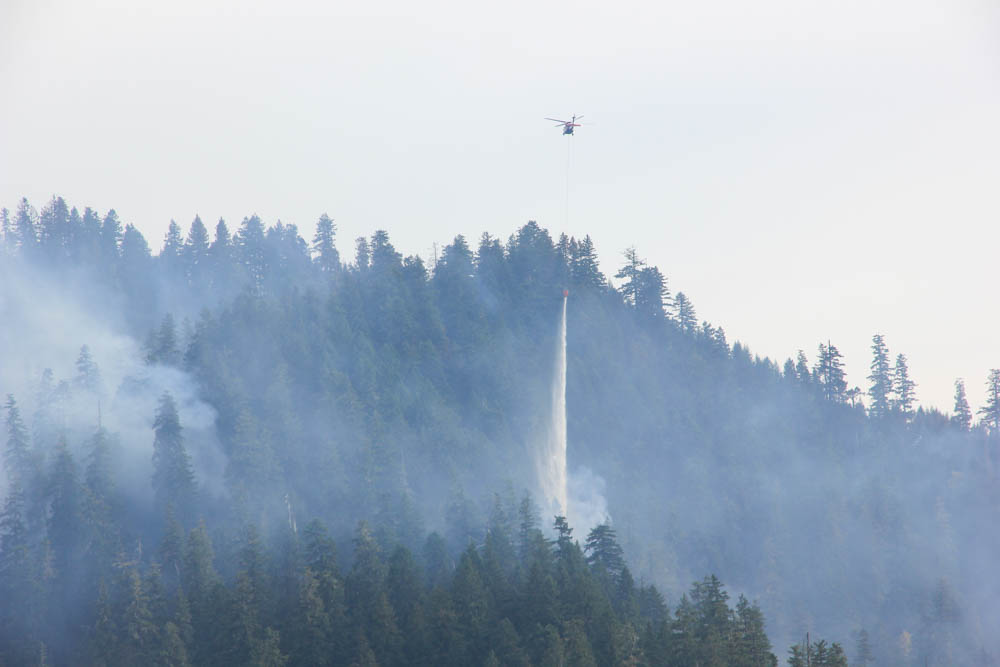
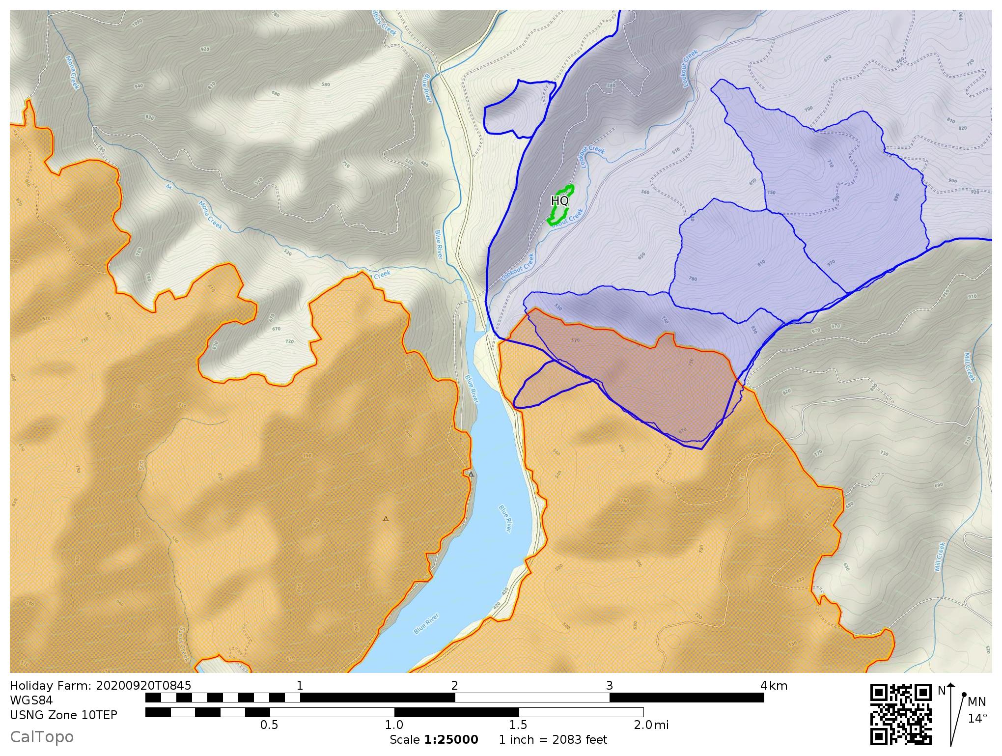
The fire continues to burn in Watershed 2. Fire crews are using air drops of water to cool down hot spots. Burned Area Emergency Response (BAER) personnel and Andrews Forest personnel are working together to plan for restoration following fire supression activities. In Watershed 2, crews have cut away trees and undergrowth and dug down to expose mineral soil to create hand lines and dozer lines to manage the spread of the fire.
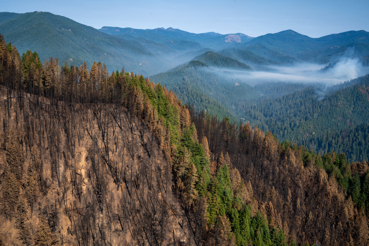
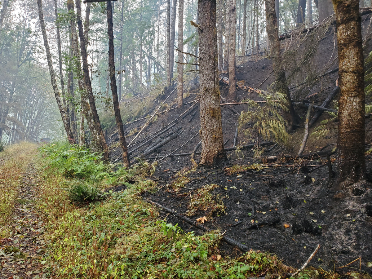
A newly-released Burn Severity Map shows that the Andrews Forest experienced low or very low burn severity--the fire crept along the ground and burned away leaf and branches on the soil.
10/7/2020
From Holiday Farm Facebook: "Suppression repair work continues to be an important focus for crews. With the weekend rains predicted, crews are working to ensure water bars are completed. The fire remains the same size at 173,094-acres and is now 80% contained. Fire behavior is expected to diminish as a more seasonal onshore weather pattern develops over the area."
At the Andrews Forest, the fire continues to burn through the old-growth stand in Watershed 2. Crews are installing water bars along fire lines, in anticipation of forecasted rains.
A new video on the Andrews Forest YouTube channel walks viewers through Watershed 1, along the north-facing slope, where the fire burned through the understory.
10/6/2020
From InciWeb: "Firefighters continue to make steady progress on containing the Holiday Farm Fire. Approximately 450 firefighters remain on the ground each day to patrol, mop up, and conduct suppression repair work. The fire remains at 173,094-acres and is 78% contained."
Specific to the Andrews Forest, where Watershed 2 continues to burn: "Fire managers have been monitoring an area on the northeast corner of the fire where it has been too dangerous to put firefighters into. This area is steep and has a lot of snags presenting overhead hazards. The fire has been creeping and smoldering in this area and is posing low risk to the fire line. Helicopters are being used to keep the fire in check by dropping water in the area as needed throughout the day. Smoke may be seen in this area, and fire managers continue to closely monitor it."
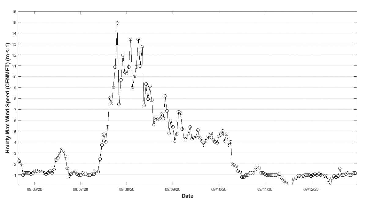
Andrews Forest personnel have been collecting data from loggers that were offline during the three-week power outage. Windspeed data from the CENMET climate station paint a clear picture of the huge wind event that powered the fire storm the night of September 7.
The major offshore wind event that fanned the flames of the Holiday Farm Fire was associated with an unusually strong cold air outbreak for this time of year that dropped down east of the Rockies. This high pressure system created strong east-to-northeast winds across Pacific Northwest, especially over the Oregon Cascades. The peak of the wind event occurred on September 8, with speeds at CENMET reaching as high as 15 m/s (33 mph). Winds gradually diminished over the next several days, reverting back to a light and variable pattern.
10/5/2020
From the Holiday Farm Fire Facebook page: "A ridge of high pressure that brings warmer and drier air is expected to rebuild over the region beginning today. Firefighters expect to see more smoke inside the fire area as relative humidity drops once again. The Incident Meteorologist is forecasting a significant change in the weather for the upcoming weekend. Forecasting models are showing varying amounts of rain, but measurable precipitation is expected to fall over the fire area beginning on Friday and persisting through the weekend. Through the hard work from firefighters, the incident is now 78% contained."
At the Andrews Forest, the fire continues to burn in Watershed 2, moving downslope towards the gage house. Fire crews are working with Andrews Forest personnel to determine the best course of action that suppresses the fire while minimizing damage to research infrastructure and long-term measurements. Our hydrology photo gallery contains pre-fire-2019 images of the Watershed 2 gage, now in danger of burning, and parts of Watershed 1 which have already burned.
10/4/2020
From InciWeb: The Holiday Farm Fire is now 173,094-acres and 75% contained. Efforts are moving into suppression restoration work. "This work is led by specially qualified personnel called Resource Advisors. The Resource Advisors on the fire determine areas that need special attention to prevent erosion, or return the area back to its pre-fire condition. Roads that may have seen heavy use will be re-shaped and graded if necessary, and ditches will be cleaned of all debris to ensure they continue to function and minimize erosion on the roadways. Over the weekend, firefighters have seen more active fire behavior on some parts of the fire. This increase is due to the warm and dry weather pattern that has been sitting over the region."
During the last week of warm, dry weather, fire activity has been slow but building within Watershed 2 at the Andrews Forest. The area within Watershed 2 is one of the last active spots of fire on the entire Holiday Farm Fire perimeter. Crews are using bucket drops of water and hand lines to suppress and control the fire's spread so it doesn't reach the Watershed 2 Gage House or cross the 1506 road to headquarters. Aerial images of the entire fire area, including the Andrews Forest, can be seen on the Sentinel Exlporer website: fill in Blue River, Oregon, and navigate from there.
10/2/2020
2:00 PM
The fire burned through three experimental watersheds within the Andrews Forest. Each watershed is home to ongoing research on water, soils, wildlife, and vegetation. The Permanent Sample Plot Program studies long-term dynamics of forest vegetation, with records going back more than 100 years. Over decades, researchers measure plant growth and mortality in specific, marked vegetation plots. In another vegetation study, researchers measure plant phenology: the timing of when plants leaf out in the spring, when they flower, or when they drop their leaves in the fall. Metal bands, called dendrometer bands, fitted around tree trunks, measure changes in the size of the tree over time. Researchers pair the phenology and dendrometer band data with our long-term climate data. Over time, patterns emerge that illustrate how plants are responding to our changing climate.
There are 130 vegetation plots in Watershed 1, two reference stand plots and 14 vegetation plots in Watershed 9, and 3 reference stands and 68 vegetation plots in Watershed 2 that may have burned in the fire. The fire has moved mostly as surface fire, but we won’t know the burn severity and tree mortality in the watersheds until it is safe to survey on the ground. Preliminary assessments found melted plastic tree tags, missing PVC plot markers, and intact metal tree tags. We anticipate a need for additional time and resources to rebuild and re-establish the permanent vegetation plots and phenology sites across the burned area.
As we move forward, the data we collect after the fire, paired with the decades of data from before the fire, will provide valuable insights into plant growth and mortality following a fire. We can look at these data over time and compare trends from the old-growth forest of Watershed 2 and Watershed 9 to the second-growth forest of Watershed 1.
12:00 PM. Hot spots of fire remain in Watershed 2. Air drops of water are being used to cool the smoldering areas until we have significant rains.
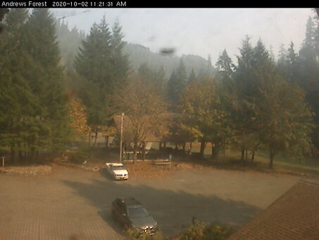
Power, internet, and data telemetry have been restored at headquarters. The headquaters webcam and other near-real time phenocams are back online, as are many of the provisional data streams.
10/1/2020
From the Holiday Farm Fire InciWeb report: "Hot and dry conditions persisted over the fire area yesterday and are forecasted again for today. Despite the weather conditions and more active fire behavior, the fire stayed in its same footprint, meaning no growth occurred. The fire has burned 173,094 acres. Firefighters continue to make steady progress and it is now 67% contained."
At the Andrews Forest, the fire continues to smolder in Watershed 2. Personnel are working to get climate stations back on telemetry, reconnecting to power, and downloading data. And, now that it's October, staff are winterizing our stream and climate stations.
9/30/2020
From InciWeb: The Holiday Farm fire stands at 173,094 acres and is now 65 percent contained. The weather forecast for today is similar to the forecast yesterday with hot and very dry conditions and light winds. Slightly cooler temperatures and higher relative humidity is called for this weekend.
Road and Willamette National Forest closures remain in place to help provide safety for the public and the firefighters.
At the Andrews Forest, fire is smoldering within Watershed 2, a stand of old-growth forest. Yesterday and today fire crews brought in helicopter air drops of water to cool down the hot spots of fire.
Check out the video of the Air-Crane water drop on the Andrews Forest YouTube channel.
9/29/2020
Fires continue to smolder in the upper portion of Watershed 2 in the Andrews Forest, and in Mona, which is across the 15 road from the Andrews Forest. Fire crews are optimistic that their containment lines will hold. Roughly 350 acres have burned within the Andrews Forest to date. We are turning our attention to getting our long-term measurements back up and running and assessing the impacts of the fire on our research infrastructure.
The size of the Holiday Farm fire stands at 173,094 acres and is now 60 percent contained.
9/28/2020
From today's InciWeb report: Fire containment is at 55 percent. The fire has not spread from its current footprint of 173,094 acres in seven days. There are 500 staff working the fire. The weather will continue to turn from warm to hot over the next few days with an east wind component that is expected to stir fire behavior inside the interior of the fire.
Near the Andrews Forest, they are still cutting lines on the SE and NE (HJA/Mona) sides. We will see more smoke with the east wind, but they don’t see any containment issues yet and they expect minimal fire growth.
The Willamette National Forest remains closed, including all of the Andrews Forest and the Blue River watershed.
9/26/2020
The Holiday Farm Fire facebook site shares the following: "The Holiday Farm Fire is now 45 percent contained. Lingering showers will keep the fire damp today, but a turn to dry, warm weather is on the horizon."
Closer to the Andrews Forest: "Fire crews have been blessed with favorable weather the past three days that has allowed close access to the fire’s edge when building direct fire lines. Much of the line construction work remains on the east side of the fire with heavy mop-up taking place throughout."
We've uploaded a second batch of images from the fire, in our Holiday Farm Fire gallery: newly-uploaded images start at #50. The images capture fire crew activities on site, fire damage to research infrastructure, and areas burned by high-severity fire at the south end of the 15 road, outside of the Andrews Forest boundary.
9/25/2020
From InciWeb: "Rainy weather continues to help suppression efforts on the Holiday Farm Fire. With some areas of the fire receiving as much as an inch-and-a-half of rain, the level of active fire on the landscape has dropped considerably. The fire remains 173,094 acres and 35 percent contained. Today’s firefighting activity includes continuing to build and improve hand and dozer fire line around the eastern third of the fire’s perimeter and ramping up mop-up operations on the remaining two-thirds."
At the Andrews Forest: Fire crews report that they are using equipment for thinning and for processing small trees. They have chippers coming in to clean up the fuel breaks they created. A type 1 crew from Canada is working on direct line to tie in to the 1510 road to control fire directly west of the Andrews Forest. They are finishing tying in hand line to the 466 road in Watershed 2. Fire was pretty quiet yesterday, but they did do some bucket drops in Watershed 2.
Weather: There has been a total of 1.5 inches of rain on east end of fire so far. Expect another inch today. Hot dry conditions return next week with northeast winds.
9/24/2020
1:00 PM
Fire containment: The whole western edge of the fire from the divisions on the SW half up to the NW half of the perimeter are in mop-up stage. Some personnel are transferring to help in Division Z and A on the east side of the Fire. Division Z, which covers the Andrews Forest, is finishing tying handline into the 1506 road and clearing along 1506 road (the 1506 is the main road through the Andrews Forest, winding along Lookout Creek). Efforts are geared towards providing strong containment in the event that drying from east winds is followed by strong SW winds – not an imminent concern at this point.
Weather: Recorded for yesterday, 0.9 – 1.2 inches of rain on fire, heaviest rain in eastern end (HJA side) this time. Today's showers won’t add up to much, but Friday looks like steady soaking rain with totals up 0.5-1 inch. Rain may continue into Saturday. Fuels are much wetter across the fire area than two weeks ago, so upcoming east wind event is a concern but will not lead to conditions anywhere near the intial conditions when the fire started.
Roads: The broader concern is plugged culverts across the fire zone which may lead to road failure – crews are looking for those situations and trying to resolve as it is safe to do so. Last night’s rain did not lead to much damage on Highway 126, just a few rocks on road. Highway 126 remains closed from milepost 27 to milepost 38, roughly between Vida and Finn Rock.
11:45 AM
This from the Holiday Farm Facebook Page:
"Protecting Science in a Changing World (From Holiday Farm FB page update: 2020-09-23)
The HJ Andrews Experimental Forest is a special place. Located north of Blue River in the Lookout Creek Watershed, it is home to old growth forests and 70 years of long-term research and monitoring on forest disturbance.
The HJ Andrews specializes in understanding big disturbance events, like the unprecedented wildfire and extreme wind event that resulted in the Holiday Farm Fire. It’s clear how we need to think about large fires and their effects on the landscape is changing. The monitoring and data gathering being conducted by the team of researchers at the HJ Andrews will be a central part of that.
But, you can’t do science if your headquarters and monitoring stations get destroyed.
The Holiday Farm Fire burned into the southern portion of the Experimental Forest but, as of Thursday September 24, 2020, the headquarters and other buildings at the compound are unharmed.
All fire teams prioritize the protection of human life and property and the team managing the Holiday Farm Fire is no different. Crews are protecting the buildings and assets on the HJ Andrews like they would any structure, from the lowliest outbuilding to million dollar homes.
Crews have built fire line around the structures at the HJ Andrews, thinned small trees along the roadside and had helicopters dropping water to keep the fire in place for several days.
“We are extremely grateful for the work of the fire crews who went above and beyond to keep the HJ Andrews safe,” says Mark Schultz, Forest Director on the HJ Andrew Experimental Forest.
Schultz, who lives and works at the Experimental Forest, says that while the loss of forests does not compare to losing one’s home, he feels an obligation to help the public understand long-term recovery and fire disturbance.
“Assuming the good work of the fire fighters holds, we are going to be very busy learning from this major disturbance,” says Schultz.
With over 1000 firefighters from 18 states and Canada—plus a good dose of old fashioned fall rains from Mother Nature—it looks like Schultz and his colleagues will soon be back in the business of doing science and making sense of a changing world."
9:30 AM
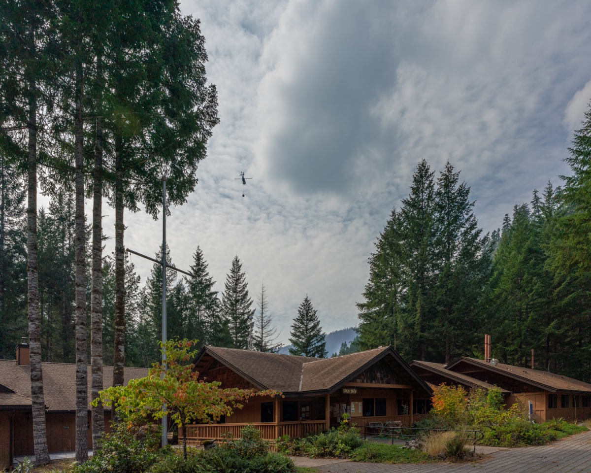
Headquarters is still intact, after yesterday's wind. Hooray! Fire crews report that our water storage tank is full and ready to flow to the hose and sprinklers that have been set up around the facility, in the event that fire encroaches.
9/23/2020
4:30 PM

Hot spots of fire that remain in the Andrews Forest are located in the upper portion of Watershed 2. Yesterday, fire crews air-dropped water to cool off the hot spots, ahead of today's forecasted wind.
After fire photo comparision: HWY 126 at the 15 road
Note that this post shows a photo of the fire on September 7 -- NOT what is happening right now.
On September 8, we posted a photo of the fire burning on the south bank of the McKenzie River, at the junction of HYW 126 and the 15 road, taken the night of Sept 7. Here is a side-by-side comparison of that location, during the fire on September 7, and after the fire on September 22.
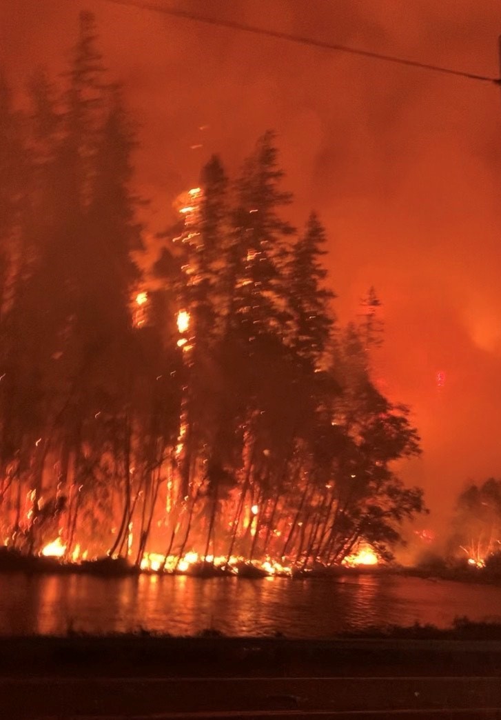
11:30 AM
First images of the fire, and its impact, are posted in our online Photo Gallery.
11:00 AM
According to today's InciWeb Update, the fire stands at 173,094 acres and is now 27 percent contained. "Elevated winds that are expected to arrive in the area early this afternoon will be the first test of containment lines since last week’s thunderstorms. Ridgetops throughout the fire have already undergone significant drying and will be exposed to sustained winds out of the south-southwest up to 20 mph with gusts up to 40 mph. Firefighters have been spending the majority of their time preparing for today’s weather event by strengthening hand and dozer lines and mopping up at least 25 feet into the interior."
Weather: It is already windy with low humidity at higher elevation in the fire area. These conditions should reach lower portions of the fire area by late mining or early afternoon ahead of the rain. The forecast is for at least ¾ of an inch of rain in lower elevations, with higher amounts of rain at higher elevations. Warm and dry conditions are expected to return on the weekend and through next week. A NE wind event is expected on Tuesday, but not an extreme event. Eugene stations are 18 inches below average precipitation on the water year, or about 38%. Season-ending precipitation could be 2-4 weeks away. Windy, hot and dry conditions will test containment lines along the fire.
At the Andrews Forest, extra crews were brought in to strengthen fire lines around headquarters and to tie hand line back into the 1506 road. The main hotspots of the fire are in Watershed 2 and across the Blue River Reservoir in the Mona area. Water drops from helicopters flew over Watershed 2 and Mona yesterday to cool hot spots.
9/22/2020
10:00 PM
A Sikorksy Firehawk helicoptor, with a 900 gallon bucket capacity, flies above headquarters at the Andrews Forest. Photo from Holiday Farm Fire facebook page, 9/22/2020.
The Holiday Farm Fire Facebook page has amazing photographs of a helicopter above the Andrews Forest headquarters and the Blue River reservoir. "Today's mission was to cool hotspots behind the HJ Andrews Experimental Forest Long-Term Ecological Research Site. The ship was dipping out of Blue River Reservoir."
Watershed 1: before and after
This pair of photos shows the same place in Watershed 1, before and after the fire.

9:00 PM.

The Holiday Farm September 22 Briefing details, "Thinning in HJA Andrews, around the compound, preparing that and getting set up for the southwesterly winds."
Staff and crew are running a generator to fill the water tank, to provide water to the sprinklers that are set up around the headquarters.
3:30 PM
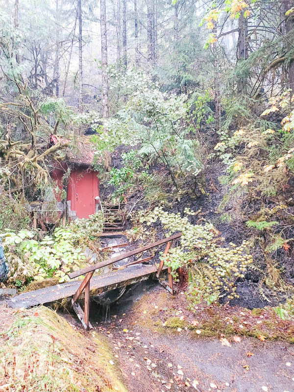
A preliminary assessment brings encouraging news: the stream gages and gage houses in Watersheds 1 and 9 are intact as of this past weekend. The fire burned to the very edge of the gage house in Watershed 1, leaving the ground blackened just up to the building foundation. A tree fell onto the gage house in Watershed 9, but did not damage the building. In Watershed 9, the fire burned the log supporting the sediment basin and some of the underground wiring for our data sensors.
Staff were able to download much of the data from the stream gages in anticipation for uncertain next steps. Looking ahead, researchers will analyze stream flow and stream chemistry to understand how the fire affects the watershed. They have decades of long-term data from these watersheds to use as a baseline.
Fire is still active within Watershed 1 and Watershed 2. The hot shot fire crew from Wyoming is working on the Watershed 2 spot fire and hopes to complete the hand work for the fire line near 1507 road. There may be bucket drops of water in the Andrews Forest and in the Mona Creek area. The rains have helped but there are still some questions as to how quiet the fire is. Crews are preparing for the winds forecasted for Wednesday, ahead of Thursday’s rain, and the east winds forecasted again for next week.
12:30 PM
Here's a shout out of appreciation to the fire crews and the McKenzie River Ranger District staff who have been working hard to protect the Andrews Forest headquarters from the fire.
10:30 AM
Today's InciWeb report shares that, "Bit by bit, containment on the Holiday Farm Fire continues to grow. Between infra-red flight data and on-the-ground truthing by field observation specialists, the fire now stands at 173,094 acres and 22 percent contained...Firefighters continue to strengthen containment lines in several other areas in advance of the weather system moving in Wednesday that will bring elevated winds out of the southwest. Rain is also expected later in the day on Wednesday."
Fire crews are active within the Andrews Forest, addressing hot spots on the landscape and strengthening defensible lines along roadways.
9/21/2020
10:00 PM
Fire crews report working along the 1506 and 130 roads, removing smaller trees along the roadsides to create a wider, more defensible line against the spread of the fire. The 130 road is the entry road into headquarters. Since the power is still out, a generator is being used to pump water into the storage tank in headquarters. The water tank is connected to sprinklers set up across the headquarters area. The sprinklers will be turned on in the event that fire enters the area. Fire continues to burn in hot spots across Watershed 9, Watershed 1, and Watershed 2.
3:00 PM
Fire continues to burn within Watershed 9, Watershed 1, and Watershed 2. There are still areas on the mid slope of the watersheds with a lot of heat and fuels, but there may be openings in the weather for bucket ships to drop water to cool off those areas.
Preparations are continuing on the 1506 road and 400 series roads (these are the roads off 1507 into WS3). Fire crews are tying in the containment line that is using the 1507 road into the 1506 road. They will open up the vegetation along the 1506 road to contain the fire on the far/south side of Lookout Creek, away from headquarters.
Yesterday's InciWeb report includes, “A primary focus today will be near and around HJ Andrews Experimental Forest just outside the northeast corner of the fire’s edge. Depending on weather, smoke and cloud cover, firefighters may be aided by a Type 1 helicopter capable of dispensing up to 3,000 gallons of water with each drop. A total of seven helicopters will be available throughout the fire area if needed."
Today’s InciWeb report states that “An overnight infrared flight of the Holiday Farm Fire revealed the new fire size at 170,637 acres, down by about 2,400 acres due to better mapping. The fire is now 17 percent contained. Firefighting personnel numbers are now at 985….Firefighters are doing all they can to strengthen containment lines and begin mop-up operations in key areas ahead of another weather system moving in Wednesday that will bring elevated winds out of the southwest. Rain is also expected later in the day on Wednesday."
9/20/2020
9:00 PM

Yesterday, September 19, 2020, Andrews Forest personnel were permitted on site to remove essential equipment and to coordinate with fire crews on safety and fire prevention details around the headquarters facility. To date, the headquarters has been spared from the fire, but the fire is only a quarter of a mile away and still active. Fire crews are working the area.
This linked video, of the 1506 road, gives us the first glimpse into what the fire has done within the boundary of the Andrews Forest. Note that the intensity of the fire is mixed within the landscape – in some areas the fire burned through the understory and scorched or took down large trees, while adjacent areas of the forest remain green and unburned.
9/19/2020
1:00 PM
Rain and cooler weather slowed the spread of the fire. We’re not out of the woods yet, so to speak, but the rains breathe new life into the long-anticipated hope that we’ve rounded the corner. And yet we know there is also much anguish, loss, and displacement. Our hearts are with our displaced staff and our neighbors in the McKenzie River community who have lost their homes and belongings.
Today, several Andrews Forest personnel were permitted a one-day trip into the headquarters area. They will grab essential equipment and set up a generator to refill the water tank, which will be used by fire crews in the event that fire enters the headquarters. The fact that our personnel were permitted into the site is hopeful -- it indicates a high level of confidence that the fire will not spread with current conditions.
We hope to post updates and images from staff, tomorrow.
9/18/2020
11:30 AM
Rain! Last night rain fell across the fires in the Oregon Cascades. While the rain wasn’t enough to stop the fires, and the eastern edge of the fire including Andrews Forest received the least, satellite data indicate a slowing in fire activity across the region. There is potential for another quarter of an inch of rain later today and tonight.
Recent hot spots at the north end of the reservoir could indicate continued movement or, possibly, represent backburning activity of fire crews. For the Mona and Andrews Forest portion of the fire zone: A type 1 crew has shifted from the southern perimeter of the fire to help with fire lines and containment to keep the fire out of Andrews Forest headquarters. The 1510 and 622 roads to the north of Mona are still holding, so if crews are able to strengthen and stabilize the lines protecting the Andrews Forest, they will shift more resources to tighten lines to contain the fire south of those roads.
As fire progress slows today, we have an opportunity to pause and reflect, and we do so within the context of loss and disturbance across the region: hundreds of families lost their homes in the fire, thousands are displaced, hazardous air has affected virtually every area of the state, well over a million acres of forest burned in Oregon, and crews continue to work tirelessly to protect structures, slow the fire, and restore critical services to affected areas.
At the Andrews Forest specifically, Watersheds 1, 2, and 9 are within the fire boundary. We don’t know yet about the intensity of the fire in the watersheds. Research infrastructure within Watersheds 1, 2, and 9, that may be affected by the fire, includes stream gages used to measure stream flow and stream chemistry for decades, a mesocosm and well field used to measure waterflow and biological activity through stream sediments and soil, vegetation plots that have been studied for decades to track changes in vegetation over time, a tower instrumented to measure air flow, soil pits used to evaluate soil type and carbon, soil moisture monitoring stations, plus various loggers, remote sensors, solar panels, and batteries used to support automated data collection. We’re uncertain about the climate station, CS2met, used to measure climate and weather data since the late 1950s (https://andrewsforest.oregonstate.edu/research/infrastructure/climate).
Researchers are already considering ways to retool and respond to the fire, within the Andrews Forest and regionally. Long-term data from the Andrews Forest provide a solid foundation for understanding the affects of the fire now and into the future.
9/17/2020
1:45 PM
For the area in around the Andrews Forest: Crews are continuing back burning and are looking at clearing a wider buffer along additional roads to help with control if the fire progresses. They are working to protect headquarters, which was mentioned very specifically in this morning’s briefing. After the rains it may be possible to shift more resources to this area from other parts of the fire perimeter. Crews feel very good about containment on the east side of the fire on the south side of the Lookout Creek (HJA) watershed down to HWY 126 and from 126 south to Cougar reservoir.
Weather: As the storm system moves in, south winds may increase enough ahead of the rain to result in mixing down to the surface, which would potentially increase fire activity. It might also clear smoke enough to allow for use of aerial resources, but increased wind without enough mixing to clear smoke is also a possibility. As the storm hits the fire area this afternoon there is potential for severe thunderstorms, with high winds, lightning, hail and downpours. The fire area should receive 0.25-0.5 inches of precipitation this afternoon and evening, with much higher amounts possible if thunderstorms impact the fire area directly. Due to this possibility there is a flash flood watch for the fire area and Cascades in Lane County more generally. The weather system is likely to impact safety measures and operations throughout the fire area today. Rain should continue on Friday.
No updated information is currently available on when power will be restored to the upper McKenzie east of Rainbow, but an update may be available soon.
8:30 AM
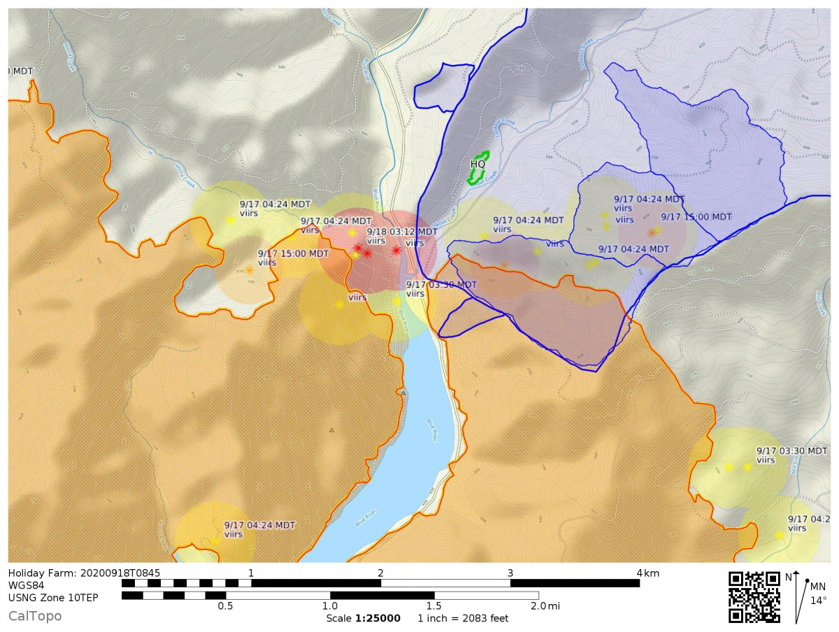
Satellite data show that the fire continues to creep, albeit slowly, into Watershed 2. The fire perimeter now encompasses Watershed 9 and most or all of Watershed 1. We have not yet heard reports from on-the-ground personnel about fire behavior and burn severity on this portion of the fire. Progression of the fire is slow, thanks to efforts of the fire crews and the cooler weather of the past week. The headquarters facilities lay just north of the fire boundary. Fire crews have put in lines and prepared the area to protect the buildings.
9/16/2020
8:00 PM

Today’s InciWeb update and Facebook Live Meeting covered information on the overall fire and suppression efforts; most of it is hopeful. The InciWeb update states that, “The suppression strategy uses a combination of roads, ridges and hand line to control the fire’s spread. Across the lengthy perimeter of the fire crews are making steady progress. Equipment operators are widening existing roads, building dozer lines and removing trees to create solid control lines. Hand crews are following up, connecting control features and completing burnout operations to remove fuels between the main body of the fire and control lines.”
As mentioned in the Facebook Live meeting, along the NE perimeter of the fire boundary, where it connects with the Andrews Forest, crews are “trying to get things worked out using the road systems.”
According to the satellite data, within the boundary of the Andrews Forest, fire has covered all of Watershed 9, moved into a large portion of Watershed 1, and is entering Watershed 2. As some background: Watersheds 9 and 2 are ancient forests, Watershed 1 has been a nexus of ecosystem studies in recent decades, and all three watersheds have been instrumented for long-term study of stream flow and water chemistry for many decades. If you’re curious about the watersheds, see Experimental Watersheds and Gauging Stations.
Rain, wind, and thunderstorms are in the forecast. As the smoke lifts, crews can bring in air support for fire suppression. The wind and thunderstorms are potentially problematic, but crews are at the ready for new fires.
1:00 PM
In the Mona and HJA area: The 1510 road is still viable as a containment line on the north end, and the fire is not moving rapidly there. Crews were able to conduct a small back burn last night in the vicinity of upper Watershed 1.
Weather: Similar to yesterday with slightly lower temps and slightly higher humidity. The weather system moving in is gradually eroding the smoke from above. There will likely be thinner smoke on the ridges and therefore more active fire. Rain probabilities are still good for Thursday, but there may be thunderstorms associated with the arrival of the weather system on Thursday afternoon. There is potential for new lightning starts and also for downpours on portions of the fire-scarred terrain. For Thursday afternoon and night, rainfall is likely in the 0.25-0.5 inch range, with higher amounts up to an inch in any downpours associated with thunderstorms.
Air support: Resources are still standing by due to smoke. There are a number of aircraft available with capacities ranging from 300-2000 gallons of water. Leaburg lake is being refilled for use by the larger helicopters for filling.
Structures along 126: Mop-up is going well around the 1000 structures within the fire footprint along Hwy 126. They are hoping to allow homeowners in to houses up as far as Deerhorn Road. Power is being returned to portions of HWY 126 above the Blue River substation.
7:00 AM:
Fire is well into Watershed 1 and covers Watershed 9. Satellite data indicate that the fire may be getting into Watershed 2. The fire progress is slow; we heard from the fire information line that, "The fire has been laying low the past few days with the cooler weather and while still growing has not made big runs."
9/15/2020 UPDATE
1:00 PM:
We just received an update from the fire crew working around and within the Andrews Forest. They completed fuel treatment around the headquarters and have the sprinklers set up. They are encouraged that they can save the buildings. They said, "it's a waiting game now." Within the boundary of the site, "firefighters are aware of limiting ground disturbance and are doing what they need to stop fire's progression." Our heartfelt thanks go out to the crews who have been working on the fire. Rain is forecasted for later in the week. We remain hopeful!
Today's InciWeb Report details efforts on clean up and asssement of structures along HWY 126.
12:00 PM.
Overall fire: Reports are down from over 200 potentially missing persons to no more than 13 unaccounted for. There were at least 1,000 structures within the fire perimeter. Structural assessment and fire mop-up efforts are ongoing and the hope is that mop-up around structures that are still standing will be completed within 48 hours. There is potential for the smoke to lift enough to use aviation resources on the fire today, but that would be accompanied by an increase in fire activity.
Mona/HJA portion of fire: As visible on the satellite maps there was an increase in fire activity last night. Crews are still trying to prevent the fire from reaching Andrews Forest infrastructure. The 1510 road is still viable as a containment line on the north side of the Mona side of the fire.
9:00 AM
Fire activity progressed into more of Watersheds 1 and 9. The fire advanced substantially on both sides of the reservoir, and now threatens to enter the Andrews Forest near the entrance road to the headquarters and the 1506 road that winds along Lookout Creek. Fire crews are working the area. We will share more information as we receive it.
9/14/2020 UPDATE
11:00 AM
New areas of fire continue to grow within Watersheds 1 and 9, and northeastward from Mona towards the bottom of the Andrews Forest watershed. Fire crews are still working on the line around the Andrews Forest and trying to contain the fire on the Mona side by using the road network including the 1510. There are now more than 800 people working on fire suppression efforts for the Holiday Farm Fire. The major concern for spread today through Wednesday will be potential for more active fire if the smoke inversion lifts. Significant rain is not forecasted for the fire zone before Thursday. The highway 126 corridor heading east from Springfield is still a major safety issue and will continue to be so for the foreseeable future. Even with just authorized vehicles in the fire zone, traffic control and safety are a major concern and challenge.
The current Inciweb report states that "An infrared flight that usually takes place overnight to show changes in fire growth did not occur last night. The most current information estimates the fire perimeter at 161,826 acres."
8:00 AM
Satellite data show new hot spots of fire along the ridge of Watershed 1, in the southwest corner of the site. Perhaps more concerning is the northeastward advancement of the fire in the Mona creek drainage, across the Blue River Reservoir. The fire coming up from Mona poses a real risk of entering the bottom of the watershed of the Andrews Forest and then running up the slopes. At this point, the fires are less than a mile from our research station facilities.
9/13/2020 UPDATE
11:00 AM:
The fire has been active in the WS1/9 and Mona area. Crews were not able to back burn the lines and they may not be able to now. The incident commander stated that protection of the Andrews Forest headquarters is a high priority. They set up sprinklers around buildings at headquarters but are waiting on using the water tank to run them since there is not an easy way to power the pump with a generator, while the power is out.
There is some positive news on power prospects for the Mckenzie corridor above the Blue River substation, which mostly survived the fire. The portion of the highway up to Blue Sky market may have power next week.
Holiday Farm Fire update from InciWeb for 9/13/2020 11:30AM
Updated evacuation notices from Lane County
9:00 AM
Satellite maps show fire activity along the southern boundary of the Andrews Forest, into Watershed 1 and Watershed 9.
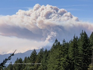
8:00 AM:
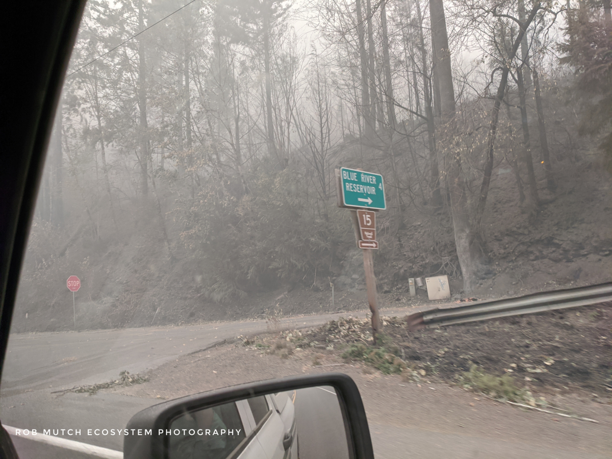
Rob Mutch, USFS Fire Lookout and photographer, sent the following report and image: "I was driven from Sisters back over to McKenzie this morning [Sept 12]. We drove through the 126 corridor up to the Blue River reservoir. It was very kafkaesque or apocalyptic with the typical moonscape of a recent fire: burning logs, standing burnt trees, dense smoke, falling ash. The burn ended about a mile [south] from the Blue Reservoir Campground."
We remain watchful as the fire moves into the south ridge along Watersheds 1 and 9. Fires moving north along the west side of the reservoir also pose a threat. Fire crews are working the area, and the weather is in their favor, with low winds, high humidity, and rain on the forecast for mid week.
9/12/2020 UPDATE
8:00 PM:
Tonight's Holiday Farm Fire Operations Update provided the following information: Along the SE edge of the fire, east of Rainbow, they are using roads and cutting control lines to move the fire away from residences. Fire activity is now moderated along the SE line. They are working all the way across the south line of the fire, trying to set a perimeter. They are working to minimize the threat along the SW, where the fire is more active. On the north side of HWY from Leaburg, they are working to close off the extensions and have been able to reduce evacuation levels in the NE area. On the north side, industry and fire teams with heavy equipment are putting in lines along the ridges and working along toward the Blue River Reservoir. Fire seems to be moving up hill and then stalling at the top of the ridges.
The fire is now at 165,000 acres (256 square miles), 5% contained (containment means that lines will hold on their own without further support). They expect to see more containment tomorrow. They need about 200 miles of perimeter and that’s going to take a while. Weather has been working in their favor, with the inversion creating some containment.
Over 600 people are assigned to the fire, with resources coming in from as far as Canada and Mexico.
Expect HWY126 to be closed to the public for a long time yet to come.
1:00 PM:
According to the Holiday Farm ODOF Incident Management report, "Yesterday, the fire grew by about 5,000 acres, raising the total to 161,826 acres. The fire perimeter is nearly 200 miles. It remains 0% contained. Calmer weather over the fire moderated fire behavior, although a few spots fire were reported and quickly controlled. A stubborn layer of thick smoke has hampered air operations, but aircraft remain available if conditions improve."
Satellite maps show heat spots inside the top of Watershed 1. We haven’t seen anything inside Watershed 9 yet, but it is close. Fire crews have been trying to do nighttime overflights, and their mapping may be more accurate than the satellite maps. We will publish a new update when we have more confirmed information. We know that fire crews are working the area and are doing their best. Our heartfelt thanks go out to the many fire crews and emergency personnel working the fires across the region.
9/11/2020 UPDATE
2:00 PM:
An InciWeb Update notes that the fire is now 156,708 acres and 0% contained.
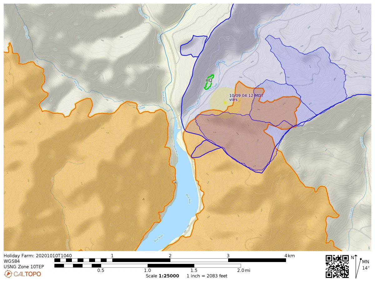
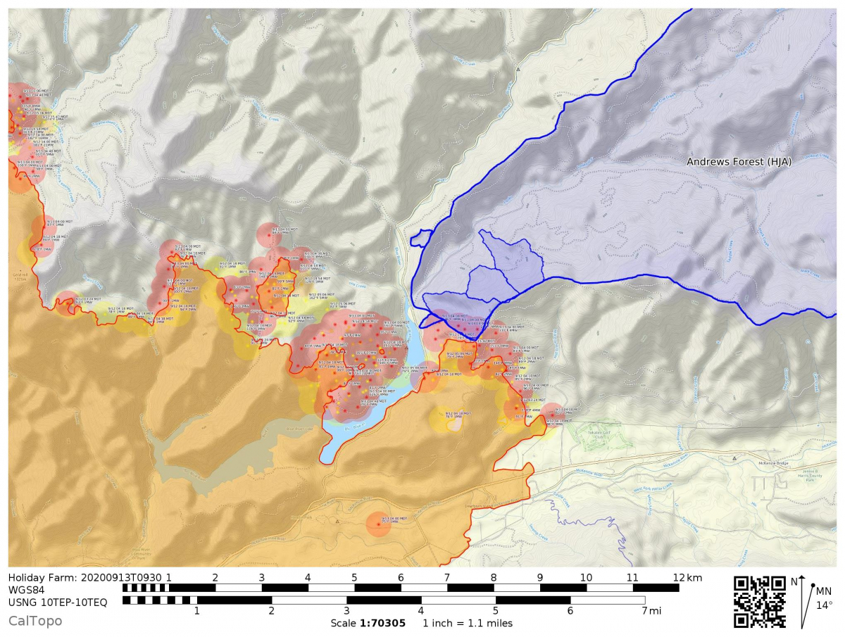
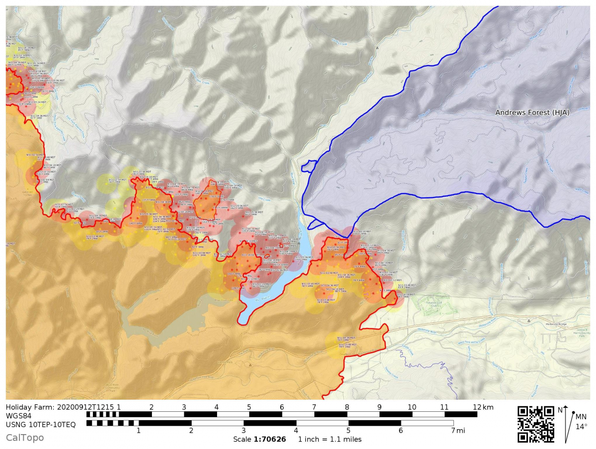
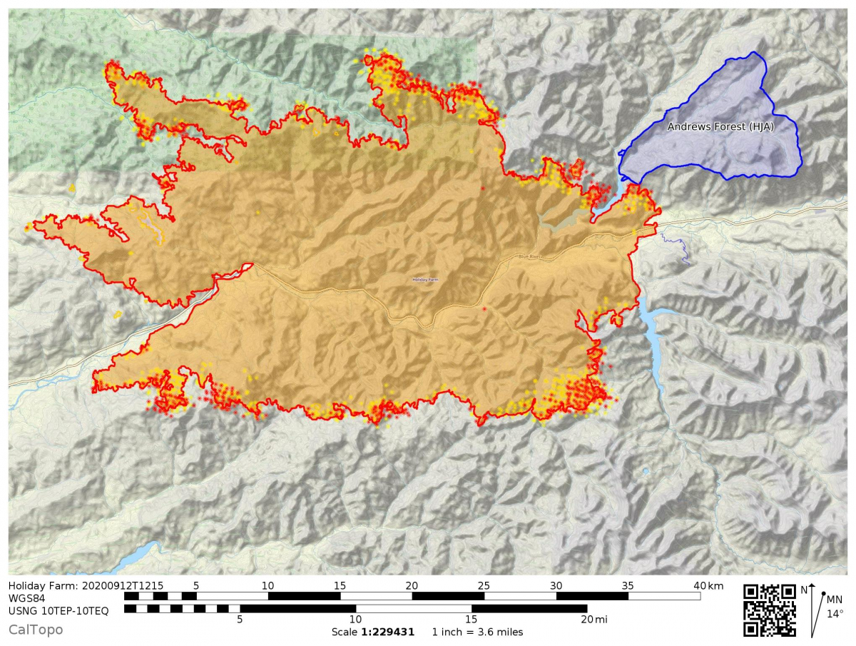
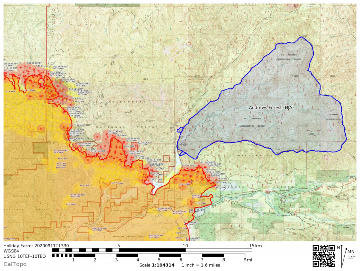
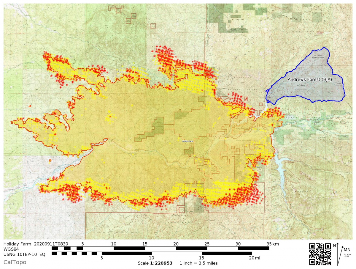
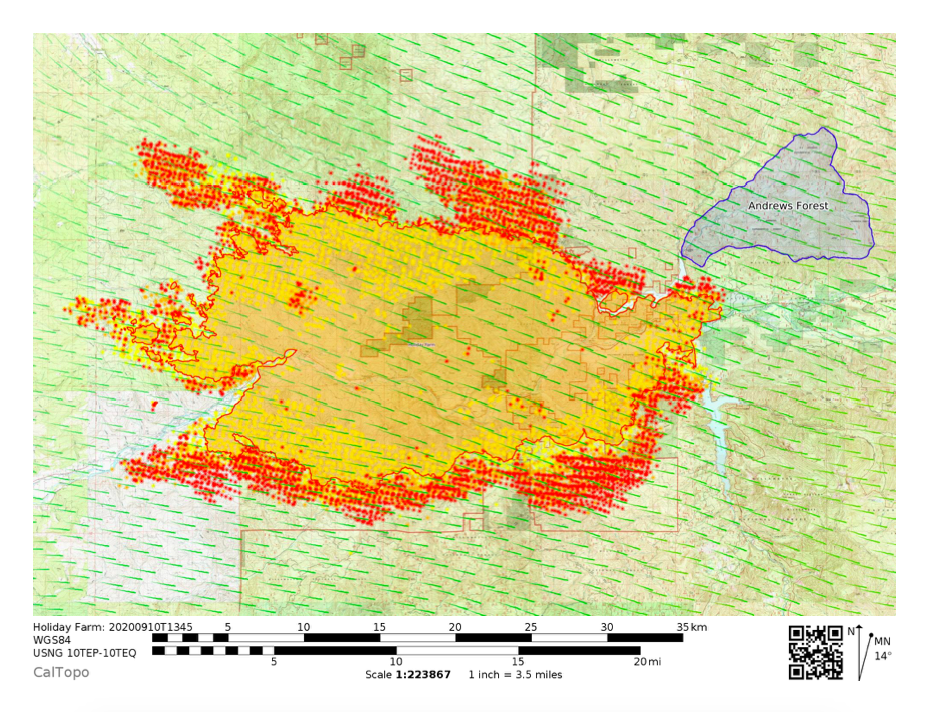
See the CalTopo fire activity map.
Note that Andrews Forest real-time data pages will not be updated until power is restored to the site or until we reconfigure the network to utilize other centers. The PRIMET climate station stopped collecting automatic data shortly after power went out on Monday, Sept 7.
10:30 AM:
North of Highway 126: Hand line has been completed on the east side of fire, tying in to 15 road along the reservoir. The hope is to back burn on that line tonight. Crews are also trying to use the 1510 road for containment on the NE edge of the fire.
South of Highway 126: Containment on the east line south to Cougar reservoir is holding and they are doing mop up along that line and trying to extend containment lines on roads to the SW.
Overall: The fire grew to ca. 156,000 acres overnight (night of Sept 10). There are 425 people assigned now to the Holiday Farm fire; 24 National Guard will arrive today to help with access control points. Nobody should be traveling on HWY 126 or into any of the evacuation zones.
9:00 AM:
Fire continues to spread throughout the area, with some progression towards the Andrews Forest site.
A September 10th press conference (30 minutes) on the Holiday Farm Fire details that the fire covers 144,586 acres, along HWY 126, and affects the communities of Rainbow, Blue River, Vida, McKenzie Bridge, Leaburg, Waterville, and Fall Creek, with significant loss of homes. There are 17,632 evacuees from the area. At about 6 minutes and 30 seconds into the press conference they show a map and explain efforts at the east end of the fire line, near the Andrews Forest. It sounds like they're working hard to hold that line. The highway and area remain closed.
See the Register Guard image gallery of the Holiday Farm Fire.
9/10/2020 UPDATE:
7:30 PM:
Fire crews are going hard trying to get containment along the 15 road at the reservoir. They don’t think they will keep the fire out of Andrews Forest entirely – it will spill over into the lower watersheds at a minimum – but they have some hope of keeping it out of headquarters. All depends upon what happens as the winds shift. Fire crews will be clearing vegetation and back-burning along the 15 road to make the containment line stronger/wider.
1:30 PM:
We have word that saving the Andrews Forest headquarters is "one of the highest priorities" for fire crews right now. Crews are "working to solidify a line on the “heel” of the fire on its eastern flank. They have an incident command set up and resources are starting to pour in, but the region is pretty strapped." Our thanks go out to the fire crews who have been working tirelessly across the region to save lives and infrastructure. New information on the fire is posted on InciWeb: "The fire was mapped using an Infrared overflight last night at 144,695 acres. Containment remains at 0%. 207 personnel are assigned to the incident. Today, firefighters are expecting to see very unstable weather conditions across the fire area. Winds are expected to shift and begin blowing out of the west today and relative humidity is expected to remain between 10-15%. These weather conditions may contribute to another day of very active fire behavior."
Staff who evacuated are spread out across the region, staying in hotels, RV parks, or in homes of friends and family. You can help by contributing to this GoFundMe fundraiser for the displaced families' emergency temporary housing expenses until they can get back to their homes.
9/9/2020 UPDATE:
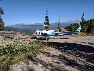
The Andrews Forest has not burned, though the fire remains at the doorstep, halfway up the Blue River Reservoir. All crew/staff evacuated successfully and are accounted for. The USFS Fire Lookout, posted on Carpenter Mountain, was evacuated successfully via helicopter.
Access to the field site is prohibited and the highway remains closed.
The Holiday Farm fire continued to move westerly, towards Eugene/Springfield, pushed by strong winds from the east. Current conditions, closures, and evacuation information can be accessed via InciWeb: https://inciweb.nwcg.gov/incident/article/7170/55358/
9/8/2020 UPDATE:
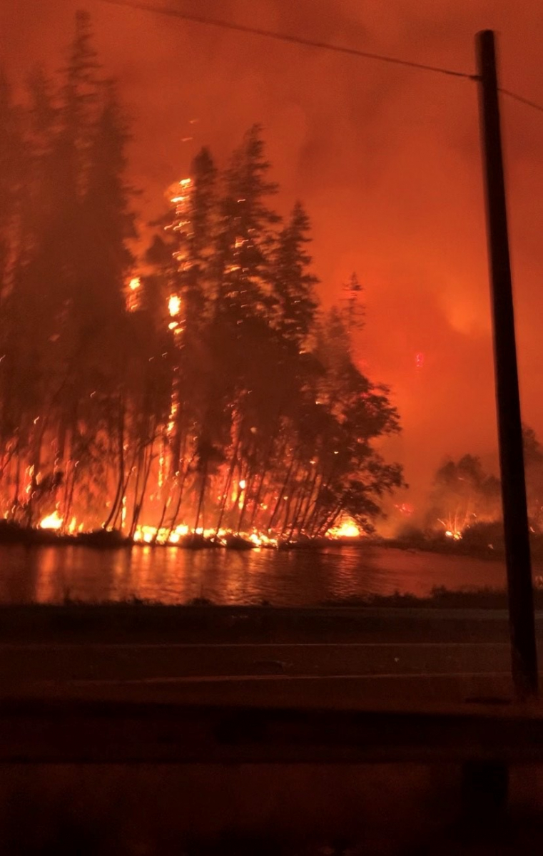
A fire in the McKenzie River corridor, near the Andrews Forest, erupted the night of September 7. The fire is spreading quickly, fueled by strong winds, high temperatures, and dry conditions.
Staff and crew that were onsite have evacuated safely from Headquarters. Staff who live along the McKenzie River have evacuated from their homes.
Conditions are changing quickly and when we know more, we will share it.
Highway 126 is closed and fire has been reported into the town of Blue River.
More information can be found on the following sites:
ArcGIS US Wildfire Activity Web Map: https://www.arcgis.com/home/webmap/viewer.html?webmap=df8bcc10430f48878b01c96e907a1fc3
AirNow Fire and Smoke Map: https://fire.airnow.gov
InciWeb: https://inciweb.nwcg.gov
National Interagency Fire Center, wildfire perimeters: https://data-nifc.opendata.arcgis.com/datasets/wildfire-perimeters?geometry=-125.833%2C43.665%2C-118.824%2C45.040
Oregon Department of Forestry, fire pages: https://www.oregon.gov/odf/fire/pages/firestats.aspx
PurpleAir, near real time air quality conditions: https://www.purpleair.com/map?opt=1/mAQI/a10/cC0#1/25/-30
RAPTOR Public 2D, real-time assessement and planning tool for Oregon: https://geo.maps.arcgis.com/apps/PublicInformation/index.html?appid=f8a0d8814a67445a9e6bf3485f4fd24f&fbclid=IwAR1LD7fRAS1-I5VSfh-kH5Mzssp6M9H6LCPED-zjlY2nU1RigHJQCYVfI0s
Zoom Earth, near real-time satellite images: https://zoom.earth/#view=41.5,-122,6z/date=2020-09-09,10:00,-7/layers=fires