Permanent Plots in the HJ Andrews Experimental Forest
Report Number 1
Permanent Plots Surrounding the
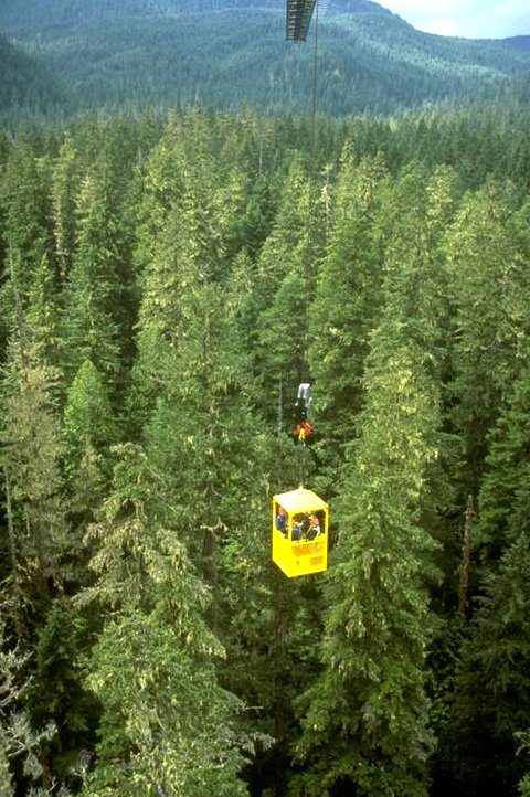
Wind River Canopy Crane
Prepared by:
Mark E. Harmon, Ken Bible, David Shaw, Suzanne Remillard, Jay Sexton,
Becky Fasth, Amy Priestley, Jiquan Chen, and Jerry F. Franklin
October 1998
Citation
Link to Wind River Canopy Crane Research Facility (WRCCRF) website (http://depts.washington.edu/wrccrf/).
CONTENTS
Citation: Harmon, M. E., K. Bible, David Shaw,
S. Remillard, J. Sexton,
B. Fasth, A. Priestley, J. Chen, and J. F. Franklin. 1998.
Permanent Plots Surrounding the Wind River Canopy Crane.
Permanent Plots of the Pacific Northwest. Report Number 1
(http://andrewsforest.oregonstate.edu/pubs/webdocs/reports/permplot.htm)
Introduction
This report describes key characteristics of vegetation
permanent plots that surround the canopy crane at Wind River
Experimental forest. The objective of this set of plots is
to describe the temporal and spatial variation in forest
structure as well as processes including growth,
recruitment, mortality, and production. The description of
this stand therefore provides key background information on
canopy process studies that are being conducted at the site.
We also report preliminary estimates of key carbon pools at
the site for those requiring these variables in modeling and
other synthetic analyzes.
Location
The permanent plots lie within the 478 ha Thornton T. Munger
Research Natural Area (RNA) in the area surrounding a free-
standing tower crane associated with the Wind River Canopy
Crane Research Facility (WRCCRF). The plot surrounding the
crane (Lat. 45° 49' 13.76'' Long. 121° 57' 06.88'') is
located at approximately 355 m in elevation on gentle (<10%
slope) topography near the southeastern flank of Trout Creek
Hill, an extinct volcano.
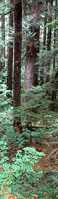
 Study Area
The forest is classified as a western hemlock/salal cover
type, and is estimated to be greater than 400 years old.
Dominant tree species are Douglas-fir (Pseudotsuga
menziesii) and western hemlock (Tsuga heterophylla).
Associated tree species include western red-cedar (Thuja
plicata), western white pine (Pinus monticola), Pacific
silver fir (Abies amabilis), grand fir (Abies grandis) and
noble fir (Abies procera). Understory trees include Pacific
yew (Taxus brevifolia) and Pacific dogwood (Cornus
nuttallii). Dominant understory shrub species are vine
maple (Acer circinatum), salal (Gaultheria shallon) and
dwarf Oregon grape (Berberis nervosa).
The climate is characteristic of a temperate winter-wet,
summer-dry climate. Annual precipitation totals 2528 mm
with less than 10% occurring between June and September.
Average annual snowfall is 2330 mm. Mean annual temperature
is 8.7 degrees C.
Soils are of the Stabler series, coarse textured (shotty
loamy sands and sandy loams) developing in 2 to 3 meters of
volcanic ejecta over basalt bedrock. A seasonal stream runs
through the plots (see
topographic map), and an extensive
wet area is located at approximately 300m to the east of the
crane.
History of the Wind River Plots
In 1994 the first of three 4 ha reference stands was
established surrounding the Wind River Canopy Crane (see
map). This plot is referred to as the "Crane plot". An
additional 4 ha plot was established in 1995 by Dr. Jiquan
Chen to the west of the crane plot and is called the
Michigan Tech Plot. The third and final 4 ha plot was also
added by Dr. Chen in 1997-98 to the south of the other two
plots and is called the Earthwatch Plot. All the plots are
contiguous and form a 400- by 300-m plot with the long axis
in the east-west direction. None of the plots has been
remeasured at the time of this report, however, annual
mortality checks have been conducted on one plot since 1995.
Methods
The boundaries of the 4 ha square "crane plot" were
established in 1994 by a licensed surveyor and oriented to
the four cardinal directions. The plot is divided into 4, 1
ha square quadrants (quadrant 0 = NE, 1 = SE, 2 = SW, 3 =
NW) each of which are further divided into 16 numbered 25-m
x 25-m subplots. Plot and subplot corners are numbered and
monumented with iron bars and vinyl surveyor caps.
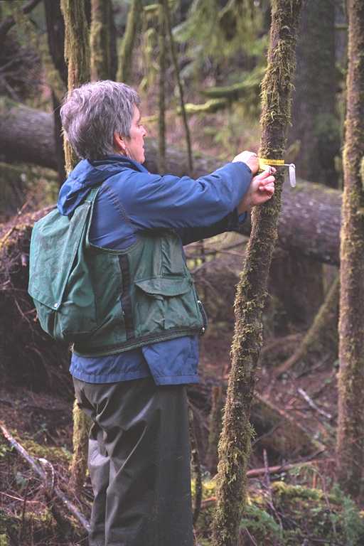
Following plot marker layout, all trees %gt;5 cm DBH were
measured for diameter, height and location from which a
stem map
was constructed. All trees equal to or greater than 5 cm
diameter at breast height (DBH) were tagged with aluminum
tags. Tags begin with a C to signify their inclusion into
the crane plot population. Diameter was measured with a
tape to the nearest 0.1 cm directly above the tag.
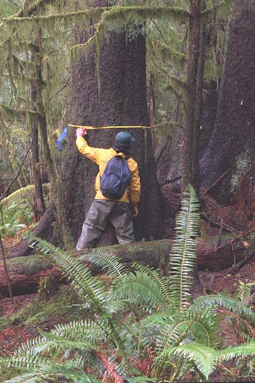
Horizontal (X) and vertical (Y) locations of trees from plot
center were determined using a Criterion 400 laser range
finder (Laser Technologies Inc.). Distances and angles to
each tree's apparent central axis were measured from each of
the 4 surrounding subplot corners. Given a clear line of
sight, 4 measurements per individual could be obtained;
however, given occluded vision fewer measurements may have
been recorded. Distances and angles were processed through
a triangulation routine which resulted in an averaged XY
coordinate for each tree (Freeman 1996). The cosign
corrected vertical height of each tree was also determined
using the Criterion 400 laser range finder or for smaller
individuals using height poles.
Biomass of all live plant parts and volume for the bole were
calculated using equations from Biopak (Means et al. 1994).
Leaf mass and leaf area index estimates are highly
uncertain. Although site-specific equations are currently
being developed, it may be sometime before these estimates
are available. We have therefore used several approaches to
try to bracket the most likely values. This includes the
Gholz et al. (1979) equations which are known to be high, a
litterfall derived estimate assuming a leaf life-span of 5
years, and a sapwood area-based estimate using DBH-sapwood
thickness relationships developed for the H. J. Andrews
forests (Means et al. in press). Total and single-sided
leaf area estimates were made using the conversion factors
of Gholz et al. (1976), Waring et al (1982) and Means et al.
(in press). To convert single-sided leaf area index values
to projected ones divide by the following numbers:
Pseudotsuga (1.18), Tsuga (1.07), and Thuja (1.5). Sapwood
volume was estimated from equations developed by Harcombe et
al. (1990) that predict the proportion of the total bole in
sapwood.
Downed coarse woody detritus (>10 cm diameter at large end)
was measured using the line intercept method (Harmon and
Sexton 1996). The diameter, species and decay class of all
downed wood crossing the boundaries between all the 25- by
25-m subplots was measured. Standing dead trees >10 cm DBH
and >1m tall were inventoried on the entire plot by
measuring the basal and top diameters and height. The mass
of downed fine wood (<10 cm diameter) was measured by
harvesting all the wood in twenty 1- by 1 m quadrats scattered
randomly throughout the 4 ha Crane plot. Several woody
detritus pools were estimated using assumptions based on the
ratios of live parts, the relative decomposition rate of the
parts, and their retention on dead boles. Below-ground fine
woody detritus in the form of dead coarse roots was
estimated assuming they form 10 to 15% of snag and log mass.
This assumption, in turn, is based on the idea that (1) the
ratio of above-ground to below-ground woody tissues holds
for dead wood and (2) roots decompose two times faster than
bole wood. Suspended fine woody debris on snags were
estimated by assuming that only decay class 1 and 2 snags
retained branches and that the suspended branch
decomposition rate equaled that of snag boles.
Soil texture, rockiness, bulk density, as well as carbon and
nitrogen content were determined in 10 soil pits that were
at least 1 m in depth. The latter three variables were
determined for three depths: 1) 0-20 cm, 2) 20-50 cm and 50-
100 cm. The mass of the organic layer was determined by 5
cores taken above the sampling face of the soil pit. These
samples were composited for each soil pit.
 General Stand Description
Site Description
- Longitude: 121° 57' 06.88''
- Latitude: 45° 49' 13.76''
- Elevation: 355 m
- Aspect: 90
- Slope: <10%
- Soil Depth: 2-3 m
- Soil Texture / Rockiness: Loamy sand-Sandy loam / 3%
- Age Class: Old-growth
- Plant Association: Tsuga heterophylla/Gautheria shallon
General Description: The forest sampled represents an old-
growth forest on the low end of the productivity gradient in
the Cascades. This is thought to be related to the soils
and the cold nature of the site.
Mistletoe infections are quite common in Tsuga and conk-rot
and butt rot are quite common in the Pseudotsuga. White
pine blister rust has weakened a substantial proportion of
the Pinus monticola, and mortality is primarily caused by
subsequent bark beetle attacks.
Plot Statistics
These statistics are an average for the entire 12 ha area.
The
Crane Plot has a higher proportion of Pseudotsuga and
Thuja than the average, as well as a slightly higher basal
area, volume and biomass.
Live Trees
Basal Area: Total basal area averages 71.7 m2/ha with 40%
and 44% comprised of Pseudotsuga and Tsuga, respectively.
Stem Numbers: The total number of stems >5 cm DBH is 444 per ha
with the majority being Tsuga (55%) and Taxus (23%).
Diameter Distribution: The normal diameter distribution of
Pseudotsuga indicates a pulse of reproduction associated
with past disturbance, ranging in DBH from 40 to 160 cm.
All other major species have a reverse-J types diameter
distribution indicating continual reproduction. The only
species approaching the size of Pseudotsuga is Thuja, which
ranges in diameter from 5 to 140 cm.
Height: The maximum tree height on the plots is 64.8 m.
This is below average for old-growth forests of the region,
and reflects the generally low site productivity of this
particular location. Taller trees do grow on the
surrounding slopes. The average tree heights of the
dominant species are Pseudotsuga (52.2 m) and Tsuga (19.0
m). Height distributions are similar to diameter
distributions with Pseudotsuga exhibiting a normal
distribution and other species a reverse-J distribution.
Canopy Cover. Canopy cover averages 70% in the stand, but
ranges from 0 to 100% cover on a 5 m grid.
Volume. Bole volume averages 1,256 m3/ha of which bole wood
comprises 87%. Pseudotsuga comprises the majority of volume
in this forest (approximately 44%). We estimate that
sapwood comprises 24% of the bole volume.
Biomass. The most credible total biomass estimate averaged
for the entire 12 ha is 813 Mg OM/ha. The high variability
of estimates is based on the foliage calculation which are
lowest for the litterfall method which gave a foliage mass
of 10 Mg OM/ha assuming a needle longevity of 5 years. This
gives a single-side leaf area index of 9.2 m2/m2, a value
that is similar to vertical intersection methods (Thomas and
Winner in prep.). The middle estimate of 18.4 Mg OM/ha of
foliage was based on the sapwood area method. The highest,
based on the Gholz equations, is 160 Mg OM/ha of foliage.
As the foliage estimates based on the latter method are
extremely high (implying a single-side LAI greater than 50
and a litterfall rate exceeding 15 Mg/ha/year!), we assume
the total biomass is closer to 813 than 1080 Mg OM/ha.
Single-side LAI, based on sapwood area, is 17 m2/m2, a value
that is probably too high.
Tsuga comprises the majority of biomass (47%), with
Pseudotsuga making up a roughly equivalent share (44%).
Combined with Thuja (6%) these three species comprise 97% of
the live biomass.
Woody Detritus:
Coarse Woody Detritus. Total volume of coarse woody
detritus averages 683 m3/ha, with 66% as downed logs. Total
mass of logs and snags is 94.8 and 68.5 Mg OM/ha,
respectively. This is very close to the estimate made by
Sollins (1982) of 150 Mg OM/ha. Pseudotsuga comprises the
majority of the coarse woody detritus, with 42% of the logs
and 76% of the snags. Tsuga is the second most abundant
species for logs (28%), whereas Pinus monticola is the
second most abundant species for snags (12%).
Fine Woody Detritus. Downed fine woody detritus averages 9
Mg OM/ha. Below-ground fine woody detritus in the form of
dead coarse roots is estimated to be between 15 and 25 Mg
OM/ha. Suspended fine woody debris on snags is
approximately 7 Mg OM/ha. Total woody detritus stores on
the site would therefore equal 194 to 204 Mg OM/ha or
equivalent to 21% of the live woody biomass. This
proportion is typical for old-growth of this region, which
have a ratio of dead to live wood of 20 to 30% (Harmon and
Chen 1991).
Soils: Sampled soil pits are consistent with the general
description of the area. Texture ranged from shotty loam to
clay. Rock content in the top 1 m averaged 3%, however,
most pits were rock free. Most pits consisted of aggregated
material >2mm in diameter which contained significant
amounts of carbon and nitrogen. A hard layer or pan was
present in many of the soil profiles at a depth of
approximately 70 to 80 cm, probably representing the
interface of two ash layers. Bulk density ranged from 0.79
and 1.07 g/cm3, with a mean of 0.93 g/cm3. Total mineral
soil nitrogen stores range from 0.42 to 2.15 kg/m2, with a
mean of 0.78 kg/m2 The forest floor contributes an
additional 0.01 to 0.07 kg/m2, with a mean of 0.04 kg/m2.
Carbon stores in the mineral soil ranged from 8.0 to 14.1 kg
C/m2, with a mean of 9.3 kg/m2 (Remillard et al.1997).
These values are probably near the mean for the Pacific
Northwest forests, which range from 3 to 35 kg of soil C/m2.
The forest floor carbon stores ranged from 0.6 to 3.3 kg/m2,
with a mean of 1.9 kg/m2. This means that only 17% of the
"soil" carbon and 5% of the nitrogen are stored in the
forest floor.
Preliminary Estimates of Carbon Stores.
We have converted the biomass figures presented above into
carbon. In the case of soil and forest floor organic matter
this was based on loss on ignition. For all other biomass
components we assumed that 50% of the organic matter was
carbon.
The total amount of
carbon currently stored in and around
the crane circle is estimated to be 614 Mg C/ha. Other
values are probably overestimates given our assessment of
the realism of the various foliage calculations. Of this
total, live vegetation, detritus, and mineral soil comprise
approximately 66, 19, and 15%, respectively. The total
amount is slightly higher (0.5%) than those reported by
Grier and Logan (1979) for Watershed 10 at the H. J.
Andrews. More significantly the Wind River site has almost
twice as much in mineral soil than Watershed 10 (9% of
total). Based on unpublished data for the full range of
forests in this region (coastal to eastside) Wind River
probably falls near the average. Our lowest estimate of
total carbon stores to date is 200 MgC/ha, whereas our
highest is 1250 MgC/ha.
Related Publications
For additional description of the site and the forest
ecosystem at the Canopy Crane Site the following references
may prove useful.
Franklin, J. F., and D. S. DeBell. 1988. Thirty-six years
of tree population change in an old-growth Pseudotsuga-Tsuga
forest, Canadian Journal of Forest Research 18:633-639.
Northwest Forest Canopies. 1996. Northwest Science, Volume
70 , Special Issue.
Sollins, P. 1982. Input and decay of coarse woody debris
in coniferous stands in Western Oregon and Washington.
Canadian Journal of Forest Research 12:18-28.
Data Access
Raw data describing the
vegetation,
woody detritus,
and soils
of these permanent plots are available on the web upon
request. Please click on the underlined text above to move
to the appropriate HMTL.
Acknowledgments
Funding for the establishment of these plots was from the
Pacific Northwest Research Station of the U.S. Forest
Service, Portland, Oregon. Additional support was provided
by WESTGEC-NIGEC, NSF-Long Term Studies (DEB-9632921) the
Corvallis Environmental Laboratory of the U.S. Environmental
Protection Agency.
References
Freeman, E. 1996. Masters Thesis, University of
Washington, Seattle, WA.
Gholz, H. L., F. K. Fitz, and R. H. Waring. 1976. Leaf
area differences associated with old-growth forest
communities in the western Oregon Cascades. Canadian
Journal of Forest Resarch 6:49-57.
Gholz, H. L., C. C. Grier, A. G. Campbell, and A. T. Brown.
1979. Equations for estimating biomass and leaf area for
plants in the Pacific Northwest. Research Paper 41, College
of Forestry, Oregon State university, Corvallis, OR. 39 p.
Grier, C. C. and R. S Logan. 1977. Old-growth Pseudotsuga
menziesii communities of a western Oregon watershed: biomass
distribution and production budgets. Ecological Monographs
47:373-400.
Harmon, M. E., and J. Sexton. 1996. Guidelines for
measurements of woody detritus in forest ecosystems. LTER
Network Publication No. 20. University of Washington,
Seattle, WA. 91 p.
Harmon, M. E. and Chen, H. 1991. Coarse woody debris
dynamics in two old-growth ecosystems: Changbai Mountain
Biosphere Reserve, People's Republic of China and H. J.
Andrews Experimental Forest, USA. Bioscience 41: 604-610 .
Means, J. E., H. A. Hansen, G. J. Koerper, P. B. Alaback,
and Mark W. Klopsch. 1994. Software for computing plant
biomass- BIOPAK users guide. USDA Forest Service General
Technical Report PNW-GTR-340. 184 p.
Remillard, S. M.; P. S. Homann; B. T. Bormann,
and M. E. Harmon. 1997. Distribution of soil organic Carbon and its relation to
climate and site characteristics in western Oregon and Washington. Soil Science
Society of America Annual Meeting, Anaheim, CA.
Waring, R. H., P. E. Schroeder, and R. Oren. 1982.
Application of the pipe model theory to predict canopy leaf
area. Canadian Journal of Forest Research 12:556-560.