Permanent Plots of the Pacific Northwest, USA
|
|
|
|
|
|
|
|
Citation: Dyrness, Ted; Acker, Steve. 2000. Permanent Plots in the Mount Rainier National Park. Permanent Plots of the Pacific Northwest. Report Number 4. (http://andrewsforest.oregonstate.edu/pubs/webdocs/reports/permplot.htm)
Eighteen permanent plots were established in representative forest ecosystems of Mount Rainier National Park in 1976 through 1978. This report describes the key characteristics of these plots (Reference Stands). This series of plots was designed to provide (1) quantitative data on changes in composition, structure, function, and biomass of the park's forest, and (2) descriptions of sites representative of the broad range of forest environments of the park where ecosystem research can be concentrated.
All 18 permanent plots are located within Mount Rainier National Park, Washington. Nine of the plots are situated in the Nisqually River drainage in the southwestern portion of the Park; 4 plots are in the White River drainage in the northeastern portion of the Park; 3 plots are in the Ohanapecosh River drainage in the southeastern portion of the Park; and, 2 plots are in the Carbon River drainage situated in the northwestern portion of the Park.
These forests and their physical setting are well described in The Forest Communities of Mount Rainier National Park by Franklin et al. (1988). Prior to this study the forest ecosystems of Mount Rainier had received little attention. From 1975 through 1980 these investigators conducted a phytosociological analysis of the forest communities of Mount Rainier National Park. The 18 permanent plots were established as a part of the study to provide information on long-term changes in forest characteristics.
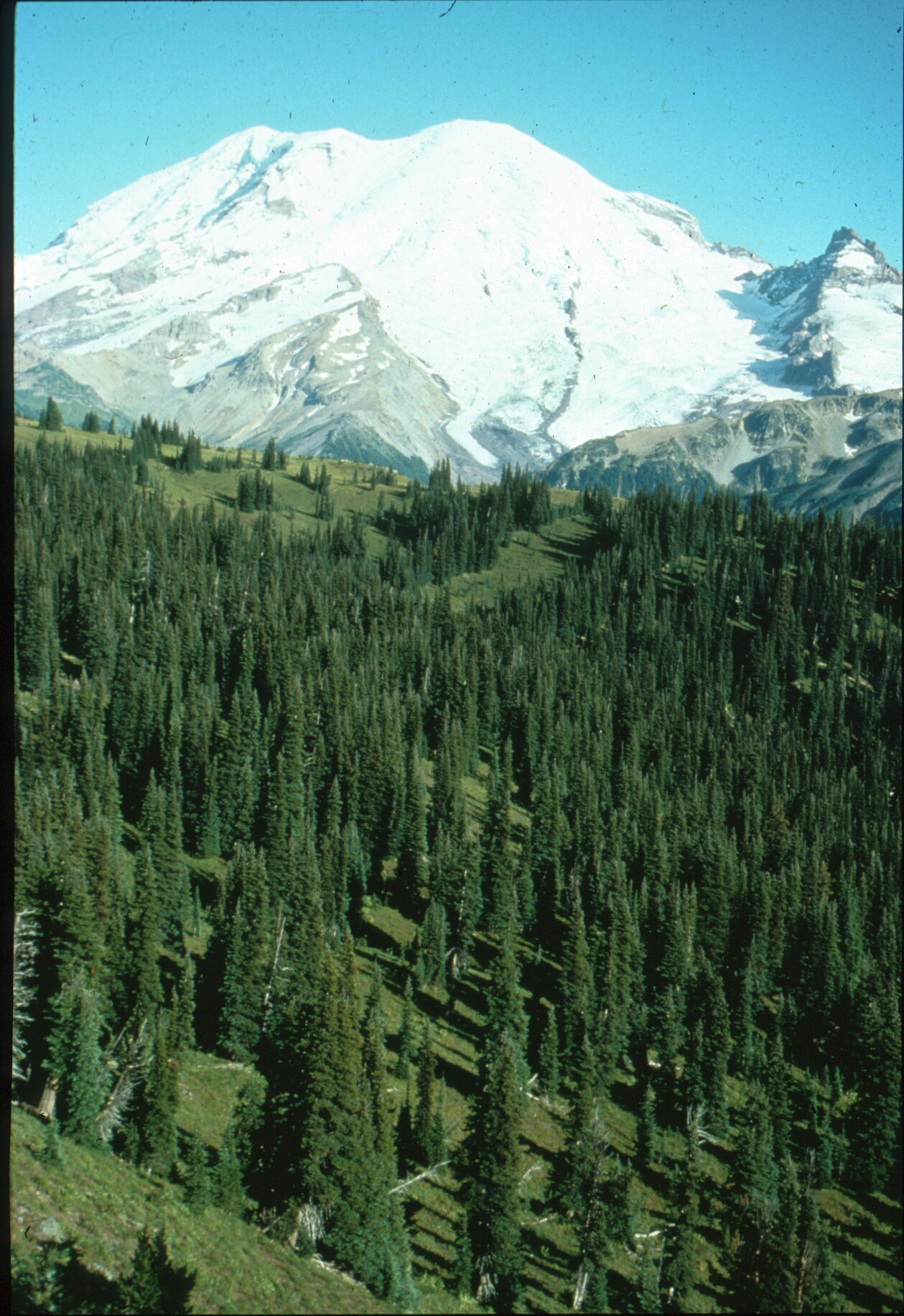
Closed coniferous forests occupy about 60 percent of the Park area, extending to elevations of about 1600 m (5,250 ft) on the western and 2000 m (6000 ft) on the northeastern slopes of Mt. Rainier. Parklands (mosaics of forest patches, tree clumps, and meadows) extend above the forest line for another 300 m (1000 ft). The forests occur within three zones based upon the major climax tree species: Tsuga heterophylla, Abies amabilis, and Tsuga mertensiana. A total of 14 plant associations and 5 community types were recognized within the Park. The moist forest types have rich understories that include numerous herbaceous species and shrubs such as Oplopanax horridum. The Abies amabilis/Vaccinium alaskaense Association is typical of modal environments and is the most extensive type in the Park. Dry associations are typified by Gaultheria shallon- and Berberis nervosa-dominated understories. High-elevational forest types belong to the cold grouping and are typified by herbaceous understories on better drained sites and by dense ericaceous shrubs on wet sites.
Mount Rainier is situated within a temperate, maritime climate. Within the Park climatic characteristics vary considerably with geographic location and elevation. In general, the White River drainage has the driest conditions, and wettest growing conditions are found in Carbon River drainage. With increasing elevation temperatures decrease and precipitation increases as a general rule. The Paradise station records the heaviest precipitation, most of it coming in the form of snow.
The geology of the area is marked by an extensive history of volcanism. Tertiary volcanism and sedimentation produced formations of sandstone, andesite, tuffs, and breccias. During the Pleistocene and Holocene eruptions produced the Rainier volcanic cone and showered the region with volcanic ash. The landscape was also greatly influenced by landslides and lahars, and glacial and fluvial events. The topography of the area around Mount Rainier is very rugged because the landscape is comparatively youthful. At lower elevations broad valleys radiating from the volcanic cone are separated by steep to vertical canyon walls. At midelevations streambed gradients are steeper and often streams are spectacularly entrenched. It is only at high elevations on upper surfaces of volcanic flows and in cirques that the topography becomes more gentle.
The soils of Mount Rainier Park have received little attention. Franklin (1966) recognized the podzolic nature of many soil profiles and described numerous buried soil horizons resulting from successive volcanic ash deposits. All soil parent materials are of Holocene age and are of glacial, alluvial, colluvial, or pyroclastic origin. The most common parent materials are pyroclastic deposits (tephras) erupted from Mount Rainier, Mount St. Helens, and, less commonly, Mount Mazama. Typical features of the soils are the development of surface organic horizons, occurrence of iron pans, and particle movement from eluvial to illuvial horizons.
One plot (AT18) was established and first measured in 1976, three plots (T01, AV02, and AO03) were established in 1977, and the remaining 14 plots were established in 1978. Plot remeasurements have been conducted at approximately 5-year intervals. Personnel involved in the establishment and initial measurements were Dick Carkin, Jack Booth, Ted Thomas, Sarah Greene, and Miles Hemstrom working under the leadership of Jerry Franklin.
Two types of plots were established in Mount Rainier Park: square hectare (100 x 100 m) plots subdivided into 25 x 25 m grids and a series of five circular plots each 1000 m2 in area. The circular plots were installed at three sites (plots AT09, AT18, and AR19), the remaining fifteen sites had square hectare plots.
The permanent sample plot was selected for its apparent homogeneity in site and stand conditions. After selecting the site, a square, one hectare plot was laid out with a staff compass and tape. Slope corrections were made if slopes exceeded 10 percent. Steel conduit was used to mark the 4 corner points, the center of the hectare, and the center of each quadrant. Cedar stakes were used to mark the remaining 25 x 25 m grid points.
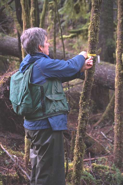
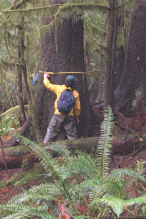
All live trees in the plot were tagged with metal numbered tags at breast height to facilitate measurement of diameter at breast height (dbh). In each quadrant, all trees greater than 5 cm. dbh were tagged in randomly selected subplots. For the remainder of the hectare only trees greater than 15 cm dbh were tagged. This procedure hastened measurement but provided data on the establishment of regeneration trees on the plots. Each tagged tree was stem mapped along with all logs and standing dead trees. In addition, tagged trees were measured for dbh and assigned to vigor classes. There were six categories of vigor classes: (1) canopy class-four classes, (2) crown condition-six classes, (3) bole condition-seven classes, (4) rooting condition-three classes, (5) disturbance condition-five classes, and (6) overall vigor. Live tree heights were determined by use of an Abney level or a Clinometer. In addition, a Barr and Stroud Dendrometer was used to assess the volume (cubic meter and board feet) and growth increment of standing live trees.
Vegetation and tree regeneration data were collected one year after the trees were measured and stem mapped. Herbaceous vegetation was measured in 200 0.5 m x 0.2 m Daubenmire microplots which were located at 1 m intervals along the 50 m boundaries of the central quadrant of the square hectare plot. The cover of each species in each microplot was recorded by the following cover classes: (1) less than 5%, (2) 5% to 25%, (3) 25% to 50%, (4) 50% to 75%, (5) 75% to 95%, and (6) 95% to 100%. Shrub species cover was estimated by line intercept. The data are pairs of numbers which denote the beginning and ending intercepts of the tape of the projected canopy of each shrub species. Tree seedlings and saplings were counted by species in four 1 m by 50 m plots adjacent to the same 50 m x 50 m central quadrant. Tree seedlings were stems between 10 cm and 150 cm in height and saplings were stems between 150 cm in height and 5 cm dbh.
Five circular plots were established in each stand, for a total plot area of 5000 m2 or 0.5 ha. The circular plots were aligned in a row with 50 m between plot centers. Plot centers were marked with a steel pole and plots were 17.9 m in radius. All live trees larger than 5 cm dbh were measured and tagged at breast height. At the time of dbh measurement tree vigor and any apparent damage to the tree were also noted. Stand tables were developed for each completed plot, thus giving a tabular perspective of plot composition and structure. The stand table was used to select a representative sample of approximately ten trees for volume determination. These trees were then measured with a Barr and Stroud Optical Dendrometer.
Herbaceous species were recorded by cover class in 0.5 m x 0.2 m microplots in the same fashion as in the square hectare plots. Fifty microplots were located in each circular plot along north-south and east-west diameter lines. Using the same diameter lines shrub cover was estimated by line intercept. A total of 50 m of shrub line intercept was measured in each of the five circular plots. As in the square hectare plots, tree regeneration was stem counted by species in two classes: 5 cm to 150 cm in height (seedlings), and 150 cm in height to 5 cm dbh (saplings). These counts were conducted in four 2 m radius circular plots located 7 m from the plot center and 45 degrees from the north-south and east-west lines. Four photographs were also taken from each plot center looking north, south, east, and west.
These permanent plots have been utilized in a number of research studies. Old growth forest characteristics have been studied, with a special emphasis on stand structure. Nine of the plots were used in a study of soil carbon and nitrogen in old-growth forests in the Pacific Northwest. Plots also have been used to compile biomass data from all forest components, including stem wood, bark, coarse roots, foliage, branches, fine woody debris, forest floor, shrubs, and coarse woody debris. The aim of this study is to determine the potential for Pacific Northwest forests to store carbon. Data from these plots have also been used to describe changes in forest characteristics through time, something permanently established forest plots are ideally suited for.
Acker, S.A., J.F. Franklin, S.E. Greene, T.B. Thomas, R. Van Pelt, and K.J. Bible. 1999. Two Decades of Forest Change in Mount Rainier National Park. Annual Meeting of Northwest Scientific Association, March 1999.
Franklin, Jerry F., William H. Moir, Miles A. Hemstrom, Sarah E. Greene, and Bradley G. Smith. 1988. The Forest Communities of Mount Rainier National Park. Scientific Monograph Series No. 19. U.S. Dept. of Interior, Nat. Park Service, Washington, D.C. 194 pp.
Greene, S., and M. Klopsch. 1985. Soil and air temperatures for different habitats in Mount Rainier National Park. Res. Paper PNW-342. U.S. Dept. Agric., For. Serv., Pac. Northwest For. and Range Exp. Sta., Portland, OR. 50 pp.
Hoffa, E.A., M.E. Harmon, S.M. Remillard, S.A Acker, et al. Potential Upper Bounds of Carbon Stores in the Pacific Northwest. Submitted to Ecological Applications.
Kuiper, L.C. 1988. The structure of natural Douglas-fir forests in western Washington and western Oregon. Agricultural University Wageningen Papers 88-5: 1-47.
Remillard, Suzanne Marie. 1999. Soil Carbon and Nitrogen in Old-Growth Forests in Western Oregon and Washington. M.S. Thesis, Oregon State University. 121 pp.
Spies, T.A., J.F. Franklin, and M. Klopsch. 1990. Canopy gaps in Douglas-fir forests of the Cascade Mountains. Can. J. For. Res. 20: 649-658.
Biek, David. 2000. Flora of Mount Rainier National Park. Oregon State University Press, Corvallis. 506 pp.
Crandell, D.R. 1968. The geologic story of Mount Rainier. Bulletin 1292. Washington, D.C.: U.S. Dept. of Interior, Geological Survey. 43 pp.
Crandell, D.R. 1969. Surficial geology of Mount Rainier National Park, Washington. U.S. Dept. of Interior, Geological Survey Bull. 1288. Washington, D.C. 75 pp.
Crandell, D.R. 1971. Postglacial lahars from Mount Rainier volcano, Washington. U.S. Dept. of Interior, Geological Survey Prof. Paper 677. Washington, D.C. 75 pp.
Crandell, D.R., and R.D. Miller. 1974. Quarternary stratigraphy and the extent of glaciation in the Mount Rainier National Park region, Washington. U.S. Dept. of Interior, Geological Survey Prof. Paper 847. Washington, D.C. 59 pp.
Fiske, R.S., C. Hopson, and A.C. Waters. 1963. Geology of Mount Rainier National Park, Washington. U.S. Dept. of Interior, Geological Survey Prof. Paper 444. Washington, D.C. 93 pp.
Franklin, J.F., and N.A. Bishop. 1969. Notes on the natural history of Mount Rainier National Park. Longmire, WA: Mount Rainier Natural History Association. 24 pp.
Franklin, J.F., and C.T. Dyrness. 1988. Natural Vegetation of Oregon and Washington. Corvallis, OR: Oregon State University Press. 452 pp.
Franklin, J.F., and M.A. Hemstrom. 1981. Aspects of succession in the coniferous forests of the Pacific Northwest. Pages 219-229 in D.C. West, H.H. Shugart, and D.B. Botkin, eds., SuccessionBconcepts and applications. Springer-Verlag, New York.
Hemstrom, M.A., and J.F. Franklin. 1982. Fire and other disturbances of the forests in Mount Rainier National Park. Quarternary Research 18: 32-51.
Henderson, J.A. 1973. Composition, distribution, and succession of subalpine meadows in Mount Rainier National Park, Washington. Ph.D. Thesis. Oregon State Univ., Corvallis. 150 pp.
Henderson, J.A., et al. 1992. Field guide to the forested plant associations and habitat types of the Mount Baker-Snoqualmie National Forest. U.S. Dept. Agric., For. Serv. Seattle, WA. 196 pp.
Moir, W.H. 1989. Forests of Mount Rainier National Park: A natural history. Seattle: Pacific Northwest National Parks and Forests Association. 111 pp.
Moir, W.H., F.D. Hobson, M. Hemstrom, and J.F. Franklin. 1979. Forest ecosystems of Mount Rainier National Park. Pages 201-207 in Proceedings, 1st conference on scientific research in the National Parks. U.S. Dept. Interior, National Park Service, Washington, D.C.
Mullineaux, D.R. 1974. Pumice and other pyroclastic deposits in Mount Rainier National Park, Washington. U.S. Dept. Interior, Geological Survey, Washington, D.C. 83 pp.
Rochefort, R.M., and D.L. Peterson. 1992. Effects of climate and other environmental factors on tree establishment in subalpine meadows of Mount Rainier National Park. Bull. of the Ecol. Soc. of America 73(2), supplement.
Starkey, E.E., J.F. Franklin, and J.W. Matthews. 1982. Fire in the forests of Mount Rainier National Park. Pages 121-126 in Ecological research in national parks of the Pacific Northwest. Corvallis: Oregon State University Forest Research Laboratory.